

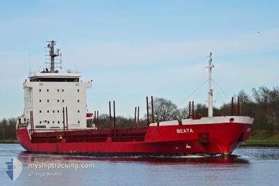
BEATA
General Cargo

Current Trip
| Trip Time | 1 day |
|---|---|
| Trip Distance | 402.95 nm |
| AVG Speed | 11.7 Knop |
| MAX Speed | 12.8 Knop |
| Djupgående | 4.2 m |
| AVG Wind | 11.5 knots |
| MAX Wind | 15.8 knots |
| MIN Temp | 0.6°C / 33.08°F |
| MAX Temp | 6.7°C / 44.06°F |
| Position mottagen | 8 h, 9 m sen |
Current Position
| Longitud | --- |
|---|---|
| Latitude | --- |
| Status | Under way using engine |
| Fart | 7.2 Knop |
| Kurs | 359.3° |
| Område | Gulf of Riga |
| Station | T-AIS |
| Position mottagen | 8 h, 9 m sen |
Information
The current position of BEATA is in Gulf of Riga with coordinates 58.56789° / 23.47703° as reported on 2025-03-24 21:58 by AIS to our vessel tracker app. The vessel's current speed is 7.2 Knop and is currently inside the port of VIRTSU.
The vessel BEATA (IMO: 9053828, MMSI: 255805882) is a General Cargo that was built in 1994 ( 31 År gammal ). It's sailing under the flag of [PT] Portugal.
In this page you can find informations about the vessels current position, last detected port calls, and current voyage information. If the vessels is not in coverage by AIS you will find the latest position.
The current position of BEATA is detected by our AIS receivers and we are not responsible for the reliability of the data. The last position was recorded while the vessel was in Coverage by the Ais receivers of our vessel tracking app.
The current draught of BEATA as reported by AIS is 4.2 meters
Weather
| Temperature | 2.5°C / 36.5°F |
|---|---|
| Wind Speed | 9 knots |
| Direction | 235° SW |
| Pressure | 1013.1 hPa |
| Humidity | 88.5 % |
| Cloud Coverage | 100 % |


Featured Company
Last Port Calls
| Port | Arrival | Departure | Time In Port |
|---|---|---|---|
| 2025-03-24 22:06 | |||
| 2025-03-22 11:42 | 2025-03-23 12:05 | 1 d | |
| 2025-03-19 11:03 | 2025-03-21 14:17 | 2 d | |
| 2025-03-08 12:46 | 2025-03-09 08:09 | 19 h | |
| 2025-03-05 15:04 | 2025-03-06 17:31 | 1 d | |
| 2025-02-28 07:18 | 2025-02-28 22:12 | 14 h | |
| 2025-02-25 16:29 | 2025-02-27 14:31 | 1 d | |
| 2025-02-17 07:26 | 2025-02-18 01:16 | 17 h | |
| 2025-02-14 01:44 | 2025-02-15 15:09 | 1 d | |
| 2025-02-07 21:27 | 2025-02-09 12:39 | 1 d |
Last Trips
| Origin | Departure | Destination | Arrival | Distance | |
|---|---|---|---|---|---|
| 2025-03-23 13:05 | 2025-03-25 00:06 | 402.95 nm | |||
| 2025-03-21 15:17 | 2025-03-22 12:42 | 173.91 nm | |||
| 2025-03-09 09:09 | 2025-03-19 12:03 | 1238.72 nm | |||
| 2025-03-06 18:31 | 2025-03-08 13:46 | 413.14 nm | |||
| 2025-03-01 00:12 | 2025-03-05 16:04 | 1090.47 nm | |||
| 2025-02-27 16:31 | 2025-02-28 09:18 | 173.12 nm | |||
| 2025-02-18 02:16 | 2025-02-25 18:29 | 1123.49 nm | |||
| 2025-02-15 16:09 | 2025-02-17 08:26 | 421.95 nm | |||
| 2025-02-09 14:39 | 2025-02-14 02:44 | 1097.49 nm | |||
| 2025-02-05 22:15 | 2025-02-07 23:27 | 386.12 nm |
Events
| Tid | Event | Detaljer | Position / Dest | Information |
|---|---|---|---|---|
| 2025-03-24 22:06 | ANLÄNDER HAMN |
|
58.57457 / 23.50437
[EE] VIRTSU
|
Fart: 7.2 kn Kurs: 359.3° |
| 2025-03-24 21:58 | UTANFÖR täckningsområde |
58.56789 / 23.47703
Gulf of Riga
EEVIR
|
Fart: 7.2 kn Kurs: 359.3° |
|
| 2025-03-24 21:35 | Byter havsområde | Estonian part of the Gulf of Riga Finnish part of the Baltic Sea |
58.50922 / 23.49286
Gulf of Riga
EEVIR
|
Fart: 11.6 kn Kurs: 24.4° |
| 2025-03-24 21:34 | I täckningsområde |
58.50922 / 23.49286
Gulf of Riga
EEVIR
|
Fart: 11.6 kn Kurs: 24.4° |
|
| 2025-03-24 05:50 | Status ändrad | Default Under way using engine |
59.47025 / 20.12364
EEVIR
|
Fart: 11.6 kn Kurs: 156° |
| 2025-03-24 05:42 | UTANFÖR täckningsområde |
59.49318 / 20.10278
Baltic Sea
EEVIR
|
Fart: 11.6 kn Kurs: 156° |
|
| 2025-03-24 05:29 | Status ändrad | Under way using engine Default |
59.53253 / 20.08019
EEVIR
|
Fart: 12 kn Kurs: 199° |
| 2025-03-24 05:26 | Status ändrad | Default Under way using engine |
59.54218 / 20.08500
EEVIR
|
Fart: 12 kn Kurs: 198.2° |
| 2025-03-24 05:25 | Status ändrad | Under way using engine Default |
59.54329 / 20.08573
EEVIR
|
Fart: 11.6 kn Kurs: 167° |
| 2025-03-24 05:02 | Status ändrad | Default Under way using engine |
59.60101 / 20.00308
EEVIR
|
Fart: 11.5 kn Kurs: 133.4° |