
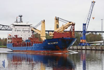
BBC OLYMPUS
General Cargo
Current Trip
NANSHA
| Time Travelled | 22 days |
|---|---|
| Remaining Time | --- |
| Distance Travelled | 7431.85 nm |
| Remaining Distance | --- |
| AVG Speed | 13.8 Knop |
| MAX Speed | 15.6 Knop |
| AVG Wind | 14 knots |
| MAX Wind | 33 knots |
| MIN Temp | -0.6°C / 30.92°F |
| MAX Temp | 23.4°C / 74.12°F |
| Djupgående | 6.1 m |
| Position mottagen | 1 m sen |
Current Position
| Longitud | --- |
|---|---|
| Latitude | --- |
| Status | Under way using engine |
| Fart | 13.7 Knop |
| Kurs | 109.5° |
| Område | North Pacific Ocean |
| Station | T-AIS |
| Position mottagen | 1 m sen |
Info
Information
The current position of BBC OLYMPUS is in North Pacific Ocean with coordinates 17.94368° / -105.89434° as reported on 2025-02-17 23:51 by AIS to our vessel tracker app. The vessel's current speed is 13.7 Knop
The vessel BBC OLYMPUS (IMO: 9508457, MMSI: 305823000) is a General Cargo that was built in 2012 ( 13 År gammal ). It's sailing under the flag of [AG] Antigua Barbuda.
In this page you can find informations about the vessels current position, last detected port calls, and current voyage information. If the vessels is not in coverage by AIS you will find the latest position.
The current position of BBC OLYMPUS is detected by our AIS receivers and we are not responsible for the reliability of the data. The last position was recorded while the vessel was in Coverage by the Ais receivers of our vessel tracking app.
The current draught of BBC OLYMPUS as reported by AIS is 6.1 meters
Weather
| Temperature | 23.3°C / 73.94°F |
|---|---|
| Wind Speed | 5 knots |
| Direction | 327° NNW |
| Pressure | 1012.5 hPa |
| Humidity | 70 % |
| Cloud Coverage | 89 % |
Featured Company
Last Port Calls
| Port | Arrival | Departure | Time In Port |
|---|---|---|---|
| 2025-01-25 08:21 | 2025-01-26 08:49 | 1 d | |
| 2025-01-03 05:00 | 2025-01-07 07:20 | 4 d | |
| 2024-12-26 16:45 | 2024-12-30 07:38 | 3 d | |
| 2024-12-22 07:04 | 2024-12-23 07:33 | 1 d | |
| 2024-12-18 21:47 | 2024-12-19 10:33 | 12 h | |
| 2024-12-13 01:12 | 2024-12-13 14:20 | 13 h |
Most Visited Ports (Last year)
| Port | Arrivals | |
|---|---|---|
| 2 | ||
| 2 | ||
| 2 | ||
| 1 | ||
| 1 | ||
| 1 |
Last Trips
| Origin | Departure | Destination | Arrival | Distance | |
|---|---|---|---|---|---|
| 2025-01-07 15:20 | 2025-01-25 16:21 | 3935.85 nm | |||
| 2024-12-30 15:38 | 2025-01-03 13:00 | 880.48 nm | |||
| 2024-12-23 15:33 | 2024-12-27 00:45 | 888.80 nm | |||
| 2024-12-19 18:33 | 2024-12-22 15:04 | 877.34 nm | |||
| 2024-12-13 22:20 | 2024-12-19 05:47 | 17.84 nm | |||
| 2024-11-27 20:34 | 2024-12-13 09:12 | 5040.73 nm |
Events
| Tid | Event | Detaljer | Position / Dest | Information |
|---|---|---|---|---|
| 2025-02-17 23:45 | Status ändrad | Under way using engine Default |
17.95249 / -105.91939
NANSHA
|
Fart: 13.8 kn Kurs: 110° |
| 2025-02-17 23:42 | Status ändrad | Default Under way using engine |
17.95547 / -105.92831
NANSHA
|
Fart: 13.5 kn Kurs: 112° |
| 2025-02-17 23:38 | Status ändrad | Under way using engine Default |
17.96101 / -105.94332
NANSHA
|
Fart: 13.8 kn Kurs: 110° |
| 2025-02-17 23:26 | Status ändrad | Default Under way using engine |
17.97800 / -105.98881
NANSHA
|
Fart: 13.7 kn Kurs: 114° |
| 2025-02-17 23:21 | Status ändrad | Under way using engine Default |
17.98635 / -106.00901
NANSHA
|
Fart: 13.6 kn Kurs: 114° |
| 2025-02-17 23:16 | Status ändrad | Default Under way using engine |
17.99395 / -106.02673
NANSHA
|
Fart: 13.7 kn Kurs: 114.4° |
| 2025-02-17 23:11 | Status ändrad | Under way using engine Default |
18.00138 / -106.04408
NANSHA
|
Fart: 14 kn Kurs: 114° |
| 2025-02-17 22:42 | Status ändrad | Default Under way using engine |
18.04630 / -106.15144
NANSHA
|
Fart: 14 kn Kurs: 111.8° |
| 2025-02-17 22:33 | Status ändrad | Under way using engine Default |
18.06001 / -106.18602
NANSHA
|
Fart: 14.1 kn Kurs: 112° |
| 2025-02-17 22:31 | Status ändrad | Default Under way using engine |
18.06406 / -106.19632
NANSHA
|
Fart: 14 kn Kurs: 112.3° |