
ATLANTIC SOUTH
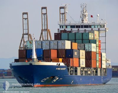
Container Ship
Current Trip
| Time Travelled | 1 day |
|---|---|
| Remaining Time | --- |
| Distance Travelled | 484.34 nm |
| Remaining Distance | 56.78 nm |
| AVG Speed | 11.3 Knop |
| MAX Speed | 13.2 Knop |
| AVG Wind | 7.5 knots |
| MAX Wind | 12.7 knots |
| MIN Temp | 14.8°C / 58.64°F |
| MAX Temp | 20.8°C / 69.44°F |
| Djupgående | 7.5 m |
| Position mottagen | 1 d sen |
Current Position
| Longitud | 129.63855° |
|---|---|
| Latitude | 35.01437° |
| Status | Under way using engine |
| Fart | 13.1 Knop |
| Kurs | 76.9° |
| Område | Japan Sea |
| Station | T-AIS |
| Position mottagen | 1 d sen |
Info
Information
The current position of ATLANTIC SOUTH is in Japan Sea with coordinates 35.01437° / 129.63855° as reported on 2024-05-18 23:04 by AIS to our vessel tracker app. The vessel's current speed is 13.1 Knop and is heading at the port of NAOETSU. The estimated time of arrival as calculated by MyShipTracking vessel tracking app is 2024-05-21 15:00 LT
The vessel ATLANTIC SOUTH (IMO: 9414137, MMSI: 563158200) is a Container Ship that was built in 2007 ( 17 År gammal ). It's sailing under the flag of [SG] Singapore.
In this page you can find informations about the vessels current position, last detected port calls, and current voyage information. If the vessels is not in coverage by AIS you will find the latest position.
The current position of ATLANTIC SOUTH is detected by our AIS receivers and we are not responsible for the reliability of the data. The last position was recorded while the vessel was in Coverage by the Ais receivers of our vessel tracking app.
The current draught of ATLANTIC SOUTH as reported by AIS is 7.5 meters
Weather
| Temperature | 14.8°C / 58.64°F |
|---|---|
| Wind Speed | 8 knots |
| Direction | 250° WSW |
| Pressure | 1014.7 hPa |
| Humidity | 92 % |
| Cloud Coverage | 88 % |
Featured Company
Last Port Calls
| Port | Arrival | Departure | Time In Port |
|---|---|---|---|
| 2024-05-18 21:17 | 2024-05-19 04:17 | 7 h | |
| 2024-05-18 06:27 | 2024-05-18 16:19 | 9 h | |
| 2024-05-14 07:33 | 2024-05-14 14:30 | 6 h | |
| 2024-05-13 06:03 | 2024-05-13 16:02 | 9 h | |
| 2024-05-10 18:23 | 2024-05-11 01:02 | 6 h | |
| 2024-05-10 03:21 | 2024-05-10 15:15 | 11 h | |
| 2024-05-07 12:33 | 2024-05-07 19:38 | 7 h | |
| 2024-05-04 08:05 | 2024-05-05 11:02 | 1 d | |
| 2024-05-01 12:12 | 2024-05-01 23:09 | 10 h | |
| 2024-04-30 18:22 | 2024-05-01 06:07 | 11 h |
Last Trips
| Origin | Departure | Destination | Arrival | Distance | |
|---|---|---|---|---|---|
| 2024-05-18 16:19 | 2024-05-18 21:17 | 30.42 nm | |||
| 2024-05-14 14:30 | 2024-05-18 06:27 | 731.32 nm | |||
| 2024-05-13 16:02 | 2024-05-14 07:33 | 179.13 nm | |||
| 2024-05-11 01:02 | 2024-05-13 06:03 | 546.39 nm | |||
| 2024-05-10 15:15 | 2024-05-10 18:23 | 27.03 nm | |||
| 2024-05-07 19:38 | 2024-05-10 03:21 | 665.12 nm | |||
| 2024-05-05 11:02 | 2024-05-07 12:33 | 293.90 nm | |||
| 2024-05-01 23:09 | 2024-05-04 08:05 | 552.42 nm | |||
| 2024-05-01 06:07 | 2024-05-01 12:12 | 43.84 nm | |||
| 2024-04-28 12:47 | 2024-04-30 18:22 | 664.01 nm |
Events
| Tid | Event | Detaljer | Position / Dest | Information |
|---|---|---|---|---|
| 2024-05-18 23:09 | Status ändrad | Default Under way using engine |
35.01800 / 129.65881
JPNAO
|
Fart: 13.1 kn Kurs: 76.9° |
| 2024-05-18 23:04 | UTANFÖR täckningsområde |
35.01437 / 129.63855
Japan Sea
JPNAO
|
Fart: 13.1 kn Kurs: 76.9° |
|
| 2024-05-18 22:30 | Djupgående ändrat | 7.5 6.7 |
34.98313 / 129.49516
JPNAO
|
Fart: 12.9 kn Kurs: 76.2° |
| 2024-05-18 22:30 | Destination ändrad | JPNAO KRPNC |
34.98313 / 129.49516
JPNAO
|
Fart: 12.9 kn Kurs: 76.2° |
| 2024-05-18 22:30 | ETA ändrat | 2024/05/21 06:00 2024/05/18 21:00 |
34.98313 / 129.49516
JPNAO
|
Fart: 12.9 kn Kurs: 76.2° |
| 2024-05-18 22:24 | Status ändrad | Under way using engine Default |
34.97833 / 129.46958
KRPNC
|
Fart: 13 kn Kurs: 76° |
| 2024-05-18 22:14 | Status ändrad | Default Under way using engine |
34.96763 / 129.42485
KRPNC
|
Fart: 13 kn Kurs: 75.2° |
| 2024-05-18 22:09 | Byter havsområde | Japanese part of the Japan Sea South Korean part of the Japan Sea |
34.96233 / 129.40277
Japan Sea
KRPNC
|
Fart: 13 kn Kurs: 75.2° |
| 2024-05-18 22:09 | Status ändrad | Under way using engine Default |
34.96233 / 129.40277
KRPNC
|
Fart: 13 kn Kurs: 71° |
| 2024-05-18 21:52 | Status ändrad | Default Under way using engine |
34.94465 / 129.33440
KRPNC
|
Fart: 12.8 kn Kurs: 70.3° |