

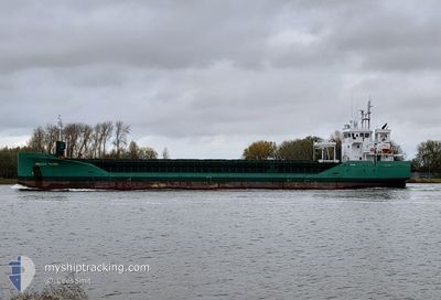
ARKLOW VIKING
Cargo

Current Trip
| Time Travelled | 2 days |
|---|---|
| Remaining Time | 12 h, 19 mins |
| Distance Travelled | 563.47 nm |
| Remaining Distance | 113.87 nm |
| AVG Speed | 11.4 Knop |
| MAX Speed | 16 Knop |
| AVG Wind | 12 knots |
| MAX Wind | 20 knots |
| MIN Temp | 8.6°C / 47.48°F |
| MAX Temp | 11.3°C / 52.34°F |
| Djupgående | 6.4 m |
| Position mottagen | 1 m sen |
Current Position
| Longitud | --- |
|---|---|
| Latitude | --- |
| Status | Under way using engine |
| Fart | 8.6 Knop |
| Kurs | 315.7° |
| Område | North Atlantic Ocean |
| Station | T-AIS |
| Position mottagen | 1 m sen |
Information
The current position of ARKLOW VIKING is in North Atlantic Ocean with coordinates 51.55055° / -10.38793° as reported on 2025-03-01 03:23 by AIS to our vessel tracker app. The vessel's current speed is 8.6 Knop and is heading at the port of FOYNES. The estimated time of arrival as calculated by MyShipTracking vessel tracking app is 2025-03-01 15:43 LT
The vessel ARKLOW VIKING (IMO: 9772606, MMSI: 244150648) is a Cargo It's sailing under the flag of [NL] Netherlands.
In this page you can find informations about the vessels current position, last detected port calls, and current voyage information. If the vessels is not in coverage by AIS you will find the latest position.
The current position of ARKLOW VIKING is detected by our AIS receivers and we are not responsible for the reliability of the data. The last position was recorded while the vessel was in Coverage by the Ais receivers of our vessel tracking app.
The current draught of ARKLOW VIKING as reported by AIS is 6.4 meters
Weather
| Temperature | 10°C / 50°F |
|---|---|
| Wind Speed | 14 knots |
| Direction | 186° S |
| Pressure | 1028.6 hPa |
| Humidity | 69.2 % |
| Cloud Coverage | 100 % |


Featured Company
Last Port Calls
| Port | Arrival | Departure | Time In Port |
|---|---|---|---|
| 2025-02-21 20:35 | 2025-02-26 16:55 | 4 d | |
| 2025-02-18 22:03 | 2025-02-20 17:55 | 1 d | |
| 2025-02-13 21:07 | 2025-02-14 13:46 | 16 h | |
| 2025-02-04 22:40 | 2025-02-07 14:39 | 2 d | |
| 2025-01-31 23:00 | 2025-02-01 20:21 | 21 h | |
| 2025-01-31 06:33 | 2025-01-31 22:53 | 16 h | |
| 2025-01-27 19:07 | 2025-01-29 17:43 | 1 d | |
| 2025-01-23 09:43 | 2025-01-24 23:33 | 1 d | |
| 2025-01-19 20:56 | 2025-01-21 20:06 | 1 d | |
| 2025-01-09 17:06 | 2025-01-12 08:38 | 2 d |
Last Trips
| Origin | Departure | Destination | Arrival | Distance | |
|---|---|---|---|---|---|
| 2025-02-20 18:55 | 2025-02-21 21:35 | 287.62 nm | |||
| 2025-02-14 14:46 | 2025-02-18 23:03 | 1202.51 nm | |||
| 2025-02-07 14:39 | 2025-02-13 22:07 | 1161.48 nm | |||
| 2025-02-01 20:21 | 2025-02-04 22:40 | 216.67 nm | |||
| 2025-01-31 22:53 | 2025-01-31 23:00 | 0.62 nm | |||
| 2025-01-29 17:43 | 2025-01-31 06:33 | 303.71 nm | |||
| 2025-01-24 23:33 | 2025-01-27 19:07 | 307.75 nm | |||
| 2025-01-21 20:06 | 2025-01-23 09:43 | 192.49 nm | |||
| 2025-01-12 09:38 | 2025-01-19 20:56 | 1252.88 nm | |||
| 2025-01-09 01:32 | 2025-01-09 18:06 | 159.65 nm |
Events
| Tid | Event | Detaljer | Position / Dest | Information |
|---|---|---|---|---|
| 2025-03-01 02:21 | Byter havsområde | Irish part of the North Atlantic Ocean French part of the Bay of Biscay |
51.43935 / -10.23393
North Atlantic Ocean
IEFOV
|
Fart: 8.5 kn Kurs: 317.7° |
| 2025-03-01 02:20 | Status ändrad | Under way using engine Default |
51.43720 / -10.23107
IEFOV
|
Fart: 9.4 kn Kurs: 319° |
| 2025-03-01 02:20 | I täckningsområde |
51.43935 / -10.23393
North Atlantic Ocean
IEFOV
|
Fart: 8.5 kn Kurs: 317.7° |
|
| 2025-02-27 11:57 | UTANFÖR täckningsområde |
46.92823 / -3.99128
Bay of Biscay
IEFOV
|
Fart: 9.5 kn Kurs: 312° |
|
| 2025-02-27 11:57 | Status ändrad | Under way using engine Default |
46.92823 / -3.99128
IEFOV
|
Fart: 9.2 kn Kurs: 312° |
| 2025-02-27 11:54 | Status ändrad | Default Under way using engine |
46.92222 / -3.98150
IEFOV
|
Fart: 9.4 kn Kurs: 312.3° |
| 2025-02-27 11:27 | I täckningsområde |
46.87708 / -3.90820
Bay of Biscay
IEFOV
|
Fart: 9.4 kn Kurs: 312.3° |
|
| 2025-02-27 10:01 | UTANFÖR täckningsområde |
46.72997 / -3.66317
Bay of Biscay
IEFOV
|
Fart: 9.7 kn Kurs: 310.9° |
|
| 2025-02-27 10:01 | I täckningsområde |
46.72997 / -3.66317
Bay of Biscay
IEFOV
|
Fart: 9.7 kn Kurs: 310.9° |
|
| 2025-02-26 21:53 | UTANFÖR täckningsområde |
45.65938 / -1.55173
Bay of Biscay
IEFOV
|
Fart: 8.7 kn Kurs: 294.4° |