
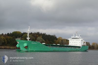
ARKLOW MILL
General Cargo
Current Trip
| Time Travelled | 2 days |
|---|---|
| Remaining Time | --- |
| Distance Travelled | 803.14 nm |
| Remaining Distance | --- |
| AVG Speed | 14.1 Knop |
| MAX Speed | 17 Knop |
| AVG Wind | 13.2 knots |
| MAX Wind | 27.1 knots |
| MIN Temp | 10.1°C / 50.18°F |
| MAX Temp | 17.6°C / 63.68°F |
| Djupgående | 5.3 m |
| Position mottagen | 9 h, 41 m sen |
Current Position
| Longitud | -10.34096° |
|---|---|
| Latitude | 51.56570° |
| Status | Under way using engine |
| Fart | 10.7 Knop |
| Kurs | 318.3° |
| Område | North Atlantic Ocean |
| Station | T-AIS |
| Position mottagen | 9 h, 41 m sen |
Info
Information
The current position of ARKLOW MILL is in North Atlantic Ocean with coordinates 51.56570° / -10.34096° as reported on 2024-05-14 14:10 by AIS to our vessel tracker app. The vessel's current speed is 10.7 Knop and is heading at the port of AUGHINISH. The estimated time of arrival as calculated by MyShipTracking vessel tracking app is 2024-05-14 20:30 LT
The vessel ARKLOW MILL (IMO: 9440265, MMSI: 250002045) is a General Cargo that was built in 2010 ( 14 År gammal ). It's sailing under the flag of [IE] Ireland.
In this page you can find informations about the vessels current position, last detected port calls, and current voyage information. If the vessels is not in coverage by AIS you will find the latest position.
The current position of ARKLOW MILL is detected by our AIS receivers and we are not responsible for the reliability of the data. The last position was recorded while the vessel was in Coverage by the Ais receivers of our vessel tracking app.
The current draught of ARKLOW MILL as reported by AIS is 5.3 meters
Weather
| Temperature | 10.1°C / 50.18°F |
|---|---|
| Wind Speed | 7 knots |
| Direction | 46° NE |
| Pressure | 996.8 hPa |
| Humidity | 94.4 % |
| Cloud Coverage | 42 % |
Featured Company
Last Port Calls
| Port | Arrival | Departure | Time In Port |
|---|---|---|---|
| 2024-05-06 03:52 | 2024-05-12 09:38 | 6 d | |
| 2024-04-30 15:58 | 2024-05-03 18:18 | 3 d | |
| 2024-04-24 21:37 | 2024-04-24 22:56 | 1 h | |
| 2024-04-21 20:56 | 2024-04-21 21:11 | 15 m | |
| 2024-04-15 13:11 | 2024-04-17 11:03 | 1 d | |
| 2024-04-05 03:24 | 2024-04-12 19:07 | 7 d | |
| 2024-03-28 05:21 | 2024-03-28 09:23 | 4 h | |
| 2024-03-26 02:58 | 2024-03-26 16:59 | 14 h | |
| 2024-03-20 12:04 | 2024-03-22 09:25 | 1 d | |
| 2024-03-17 08:09 | 2024-03-18 13:49 | 1 d |
Last Trips
| Origin | Departure | Destination | Arrival | Distance | |
|---|---|---|---|---|---|
| 2024-05-03 20:18 | 2024-05-06 04:52 | 492.37 nm | |||
| 2024-04-25 00:56 | 2024-04-30 17:58 | 514.47 nm | |||
| 2024-04-21 23:11 | 2024-04-24 23:37 | 17.69 nm | |||
| 2024-04-17 13:03 | 2024-04-21 22:56 | 766.87 nm | |||
| 2024-04-12 20:07 | 2024-04-15 15:11 | 592.20 nm | |||
| 2024-03-28 10:23 | 2024-04-05 04:24 | 1206.10 nm | |||
| 2024-03-26 17:59 | 2024-03-28 06:21 | 214.33 nm | |||
| 2024-03-22 10:25 | 2024-03-26 03:58 | 505.94 nm | |||
| 2024-03-18 14:49 | 2024-03-20 13:04 | 504.61 nm | |||
| 2024-03-15 13:18 | 2024-03-17 09:09 | 411.31 nm |
Events
| Tid | Event | Detaljer | Position / Dest | Information |
|---|---|---|---|---|
| 2024-05-14 22:57 | STOPPAR förflyttning | 3.13 nm, South West of CAPPA UPPER |
52.60014 / -9.57147
AUGHINISH
|
Fart: 0.2 kn Kurs: 67° |
| 2024-05-14 14:10 | UTANFÖR täckningsområde |
51.56570 / -10.34096
North Atlantic Ocean
AUGHINISH
|
Fart: 10.7 kn Kurs: 318.3° |
|
| 2024-05-14 12:49 | Byter havsområde | Irish part of the North Atlantic Ocean Irish part of the Celtic Sea |
51.40593 / -9.96791
North Atlantic Ocean
AUGHINISH
|
Fart: 13.7 kn Kurs: 303.8° |
| 2024-05-14 10:48 | Status ändrad | Under way using engine Default |
51.18659 / -9.31663
AUGHINISH
|
Fart: 13.8 kn Kurs: 291° |
| 2024-05-14 10:48 | I täckningsområde |
51.18659 / -9.31663
Celtic Sea
AUGHINISH
|
Fart: 13.7 kn Kurs: 291.3° |
|
| 2024-05-14 08:54 | Status ändrad | Default Under way using engine |
51.03140 / -8.67871
AUGHINISH
|
Fart: 12.9 kn Kurs: 289.2° |
| 2024-05-14 08:52 | UTANFÖR täckningsområde |
51.02906 / -8.66888
Celtic Sea
AUGHINISH
|
Fart: 12.9 kn Kurs: 289.2° |
|
| 2024-05-14 08:02 | ETA ändrat | 2024/05/14 20:30 2024/05/14 20:00 |
50.96090 / -8.38205
AUGHINISH
|
Fart: 13.5 kn Kurs: 290.2° |
| 2024-05-14 05:42 | Upptäckt i hav | Irish part of the Celtic Sea |
50.76673 / -7.56841
Celtic Sea
AUGHINISH
|
Fart: 14.3 kn Kurs: 290.9° |
| 2024-05-14 05:42 | Status ändrad | Under way using engine Default |
50.76673 / -7.56841
AUGHINISH
|
Fart: 14.4 kn Kurs: 289° |