
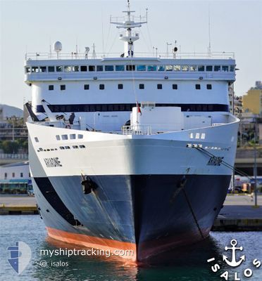
ARIADNE
Ro-Ro/Passenger Ship
Current Trip
| Time Travelled | 2 h, 52 mins |
|---|---|
| Remaining Time | --- |
| Distance Travelled | 58.37 nm |
| Remaining Distance | --- |
| AVG Speed | 21.1 Knop |
| MAX Speed | 21.6 Knop |
| AVG Wind | 12.8 knots |
| MAX Wind | 17 knots |
| MIN Temp | 15.5°C / 59.9°F |
| MAX Temp | 17.4°C / 63.32°F |
| Djupgående | 6.8 m |
| Position mottagen | 1 m sen |
Current Position
| Longitud | --- |
|---|---|
| Latitude | --- |
| Status | Under way using engine |
| Fart | 21.2 Knop |
| Kurs | 2° |
| Område | Aegean Sea |
| Station | T-AIS |
| Position mottagen | 1 m sen |
Info
Information
The current position of ARIADNE is in Aegean Sea with coordinates 36.41428° / 24.21813° as reported on 2026-01-05 22:06 by AIS to our vessel tracker app. The vessel's current speed is 21.2 Knop
The vessel ARIADNE (IMO: 9135262, MMSI: 240580000) is a Ro-Ro/Passenger Ship that was built in 1996 ( 30 År gammal ). It's sailing under the flag of [GR] Greece.
In this page you can find informations about the vessels current position, last detected port calls, and current voyage information. If the vessels is not in coverage by AIS you will find the latest position.
The current position of ARIADNE is detected by our AIS receivers and we are not responsible for the reliability of the data. The last position was recorded while the vessel was in Coverage by the Ais receivers of our vessel tracking app.
The current draught of ARIADNE as reported by AIS is 6.8 meters
Weather
| Temperature | 17.3°C / 63.14°F |
|---|---|
| Wind Speed | 10 knots |
| Direction | 160° SSE |
| Pressure | 1015.8 hPa |
| Humidity | 71.7 % |
| Cloud Coverage | 28 % |
Featured Company
Last Port Calls
| Port | Arrival | Departure | Time In Port |
|---|---|---|---|
| 2026-01-05 07:02 | 2026-01-05 21:16 | 14 h | |
| 2026-01-05 02:30 | 2026-01-05 02:58 | 28 m | |
| 2026-01-04 05:57 | 2026-01-04 22:16 | 16 h | |
| 2026-01-04 01:31 | 2026-01-04 02:00 | 28 m | |
| 2026-01-03 07:09 | 2026-01-03 21:16 | 14 h | |
| 2026-01-03 02:38 | 2026-01-03 02:55 | 16 m | |
| 2026-01-02 05:51 | 2026-01-02 22:16 | 16 h | |
| 2026-01-02 01:29 | 2026-01-02 01:46 | 17 m | |
| 2025-12-31 07:02 | 2026-01-01 21:16 | 1 d | |
| 2025-12-31 02:36 | 2025-12-31 02:58 | 21 m |
Last Trips
| Origin | Departure | Destination | Arrival | Distance | |
|---|---|---|---|---|---|
| 2026-01-05 02:58 | 2026-01-05 07:02 | 87.39 nm | |||
| 2026-01-04 22:16 | 2026-01-05 02:30 | 85.17 nm | |||
| 2026-01-04 02:00 | 2026-01-04 05:57 | 84.99 nm | |||
| 2026-01-03 21:16 | 2026-01-04 01:31 | 86.84 nm | |||
| 2026-01-03 02:55 | 2026-01-03 07:09 | 87.05 nm | |||
| 2026-01-02 22:16 | 2026-01-03 02:38 | 86.39 nm | |||
| 2026-01-02 01:46 | 2026-01-02 05:51 | 85.07 nm | |||
| 2026-01-01 21:16 | 2026-01-02 01:29 | 86.42 nm | |||
| 2025-12-31 02:58 | 2025-12-31 07:02 | 87.30 nm | |||
| 2025-12-30 22:15 | 2025-12-31 02:36 | 85.83 nm |
Events
| Tid | Event | Detaljer | Position / Dest | Information |
|---|---|---|---|---|
| 2026-01-05 21:49 | ETA ändrat | 2026/01/05 23:25 2026/01/05 23:00 |
36.31117 / 24.21952
GRADL
|
Fart: 21.4 kn Kurs: 357° |
| 2026-01-05 19:16 | AVGÅTT HAMN |
|
35.48647 / 24.11675
GRADL
|
Fart: 14.7 kn Kurs: 102° |
| 2026-01-05 19:06 | STARTAR förflyttning |
35.49235 / 24.07705
[GR] SOUDA
|
Fart: 4.9 kn Kurs: 24° |
|
| 2026-01-05 19:01 | Status ändrad | Under way using engine Moored |
35.49040 / 24.07623
[GR] SOUDA
|
Fart: Kurs: 21° |
| 2026-01-05 18:45 | Destination ändrad | GRADL GRSDH |
35.49045 / 24.07620
[GR] SOUDA
|
Fart: Kurs: 21° |
| 2026-01-05 18:45 | ETA ändrat | 2026/01/05 23:00 2026/01/05 05:00 |
35.49045 / 24.07620
[GR] SOUDA
|
Fart: Kurs: 21° |
| 2026-01-05 05:32 | Status ändrad | Moored Under way using engine |
35.49040 / 24.07625
[GR] SOUDA
|
Fart: Kurs: 22° |
| 2026-01-05 05:22 | STOPPAR förflyttning |
35.49045 / 24.07625
[GR] SOUDA
|
Fart: 0.3 kn Kurs: 23° |
|
| 2026-01-05 05:02 | ANLÄNDER HAMN |
|
35.48768 / 24.11462
[GR] SOUDA
|
Fart: 15.8 kn Kurs: 283° |
| 2026-01-05 01:38 | Destination ändrad | GRSDH GRADL |
36.64925 / 24.27217
GRSDH
|
Fart: 22.3 kn Kurs: 197° |