

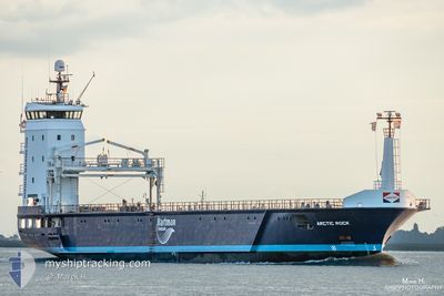
ARCTIC ROCK
General Cargo

Current Trip
UDEVALA
| Time Travelled | 3 days |
|---|---|
| Remaining Time | --- |
| Distance Travelled | 846.84 nm |
| Remaining Distance | --- |
| AVG Speed | 11.9 Knop |
| MAX Speed | 15.5 Knop |
| AVG Wind | 10.2 knots |
| MAX Wind | 17 knots |
| MIN Temp | 6.7°C / 44.06°F |
| MAX Temp | 12.7°C / 54.86°F |
| Djupgående | 4.7 m |
| Position mottagen | Nu |
Current Position
| Longitud | --- |
|---|---|
| Latitude | --- |
| Status | Under way using engine |
| Fart | 11.7 Knop |
| Kurs | 17.4° |
| Område | North Sea |
| Station | T-AIS |
| Position mottagen | Nu |
Information
The current position of ARCTIC ROCK is in North Sea with coordinates 53.55157° / 4.79101° as reported on 2025-03-29 07:53 by AIS to our vessel tracker app. The vessel's current speed is 11.7 Knop
The vessel ARCTIC ROCK (IMO: 9650901, MMSI: 245058000) is a General Cargo that was built in 2014 ( 11 År gammal ). It's sailing under the flag of [NL] Netherlands.
In this page you can find informations about the vessels current position, last detected port calls, and current voyage information. If the vessels is not in coverage by AIS you will find the latest position.
The current position of ARCTIC ROCK is detected by our AIS receivers and we are not responsible for the reliability of the data. The last position was recorded while the vessel was in Coverage by the Ais receivers of our vessel tracking app.
The current draught of ARCTIC ROCK as reported by AIS is 4.7 meters
Weather
| Temperature | 6.7°C / 44.06°F |
|---|---|
| Wind Speed | 10 knots |
| Direction | 294° WNW |
| Pressure | 1017.3 hPa |
| Humidity | 88.5 % |
| Cloud Coverage | --- |


Featured Company
Last Port Calls
| Port | Arrival | Departure | Time In Port |
|---|---|---|---|
| 2025-03-24 14:07 | 2025-03-26 07:36 | 1 d | |
| 2025-03-18 15:45 | 2025-03-19 16:46 | 1 d | |
| 2025-03-18 10:55 | 2025-03-18 10:58 | 2 m | |
| 2025-03-12 17:21 | 2025-03-13 22:29 | 1 d | |
| 2025-03-07 16:43 | 2025-03-09 22:25 | 2 d | |
| 2025-02-27 22:01 | 2025-03-03 00:12 | 3 d | |
| 2025-02-27 10:27 | 2025-02-27 19:28 | 9 h | |
| 2025-02-20 17:30 | 2025-02-26 19:32 | 6 d | |
| 2025-02-16 20:16 | 2025-02-17 20:48 | 1 d | |
| 2025-02-11 05:17 | 2025-02-11 06:08 | 50 m |
Last Trips
| Origin | Departure | Destination | Arrival | Distance | |
|---|---|---|---|---|---|
| 2025-03-19 16:46 | 2025-03-24 14:07 | 1127.14 nm | |||
| 2025-03-18 10:58 | 2025-03-18 15:45 | 51.63 nm | |||
| 2025-03-13 22:29 | 2025-03-18 10:55 | 1034.22 nm | |||
| 2025-03-09 22:25 | 2025-03-12 17:21 | 771.65 nm | |||
| 2025-03-03 00:12 | 2025-03-07 16:43 | 230.15 nm | |||
| 2025-02-26 19:32 | 2025-02-27 22:01 | 182.21 nm | |||
| 2025-02-26 19:32 | 2025-02-27 10:27 | 159.15 nm | |||
| 2025-02-17 20:48 | 2025-02-20 17:30 | 749.46 nm | |||
| 2025-02-11 06:08 | 2025-02-16 20:16 | 948.26 nm | |||
| 2025-02-10 20:24 | 2025-02-11 05:17 | 33.34 nm |
Events
| Tid | Event | Detaljer | Position / Dest | Information |
|---|---|---|---|---|
| 2025-03-29 06:20 | Status ändrad | Under way using engine Default |
53.25711 / 4.62927
UDEVALA
|
Fart: 12.5 kn Kurs: 20° |
| 2025-03-29 05:43 | Status ändrad | Default Under way using engine |
53.13575 / 4.57348
UDEVALA
|
Fart: 12.6 kn Kurs: 4° |
| 2025-03-28 21:20 | Status ändrad | Under way using engine Default |
52.26103 / 3.36876
UDEVALA
|
Fart: 10.3 kn Kurs: 43° |
| 2025-03-28 21:00 | Status ändrad | Default Under way using engine |
52.21834 / 3.30368
UDEVALA
|
Fart: 10 kn Kurs: 117.1° |
| 2025-03-28 20:50 | Status ändrad | Under way using engine Default |
52.20176 / 3.27003
UDEVALA
|
Fart: 10.1 kn Kurs: 49° |
| 2025-03-28 20:26 | Status ändrad | Default Under way using engine |
52.17032 / 3.21796
UDEVALA
|
Fart: 10 kn Kurs: 44.3° |
| 2025-03-28 17:29 | Byter havsområde | Dutch part of the North Sea Belgian part of the North Sea |
51.79646 / 2.67818
North Sea
UDEVALA
|
Fart: 10.9 kn Kurs: 43.9° |
| 2025-03-28 15:34 | Byter havsområde | Belgian part of the North Sea French part of the North Sea |
51.52272 / 2.27111
North Sea
UDEVALA
|
Fart: 12.3 kn Kurs: 49.2° |
| 2025-03-28 14:44 | Byter havsområde | French part of the North Sea United Kingdom part of the North Sea |
51.39894 / 2.07601
North Sea
UDEVALA
|
Fart: 12.8 kn Kurs: 40.5° |
| 2025-03-28 13:02 | Byter havsområde | United Kingdom part of the North Sea French part of the North Sea |
51.10162 / 1.71611
North Sea
UDEVALA
|
Fart: 14.1 kn Kurs: 22.4° |