

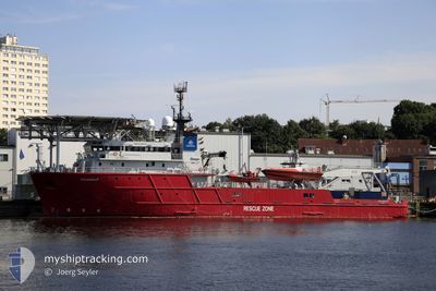
AQUANAUT
Offshore Supply Ship

Current Trip
DIVING EXERCISE
| Time Travelled | 1 day |
|---|---|
| Remaining Time | --- |
| Distance Travelled | 2.51 nm |
| Remaining Distance | --- |
| AVG Speed | 10.4 Knop |
| MAX Speed | 11.7 Knop |
| AVG Wind | 1 knots |
| MAX Wind | 1.2 knots |
| MIN Temp | -6.1°C / 21.02°F |
| MAX Temp | -4.6°C / 23.72°F |
| Djupgående | 5.9 m |
| Position mottagen | 13 m sen |
Current Position
| Longitud | --- |
|---|---|
| Latitude | --- |
| Status | At anchor |
| Fart | |
| Kurs | 305° |
| Område | Baltic Sea |
| Station | T-AIS |
| Position mottagen | 13 m sen |
Information
The current position of AQUANAUT is in Baltic Sea with coordinates 54.05853° / 10.79481° as reported on 2025-02-18 12:56 by AIS to our vessel tracker app. The vessel's current speed is 0 Knop
The vessel AQUANAUT (IMO: 9296717, MMSI: 218481000) is a Offshore Supply Ship that was built in 2003 ( 22 År gammal ). It's sailing under the flag of [DE] Germany.
In this page you can find informations about the vessels current position, last detected port calls, and current voyage information. If the vessels is not in coverage by AIS you will find the latest position.
The current position of AQUANAUT is detected by our AIS receivers and we are not responsible for the reliability of the data. The last position was recorded while the vessel was in Coverage by the Ais receivers of our vessel tracking app.
The current draught of AQUANAUT as reported by AIS is 5.9 meters
Weather
| Temperature | -0.5°C / 31.1°F |
|---|---|
| Wind Speed | 3 knots |
| Direction | 271° W |
| Pressure | 1031 hPa |
| Humidity | 54.7 % |
| Cloud Coverage | 1 % |


Featured Company
Last Port Calls
Most Visited Ports (Last year)
| Port | Arrivals | |
|---|---|---|
| 13 | ||
| 5 | ||
| 4 | ||
| 2 | ||
| 2 |
Last Trips
| Origin | Departure | Destination | Arrival | Distance | |
|---|---|---|---|---|---|
| 2025-02-10 12:14 | 2025-02-14 11:21 | 66.50 nm | |||
| 2025-02-09 14:35 | 2025-02-09 21:47 | 89.76 nm | |||
| 2025-01-16 08:57 | 2025-01-16 15:33 | 51.92 nm | |||
| 2024-12-09 08:15 | 2024-12-13 17:49 | 313.93 nm | |||
| 2024-12-02 08:17 | 2024-12-06 11:42 | 9.21 nm |
Events
| Tid | Event | Detaljer | Position / Dest | Information |
|---|---|---|---|---|
| 2025-02-17 12:29 | I täckningsområde |
54.05848 / 10.79477
Baltic Sea
DIVING EXERCISE
|
Fart: Kurs: 214.7° |
|
| 2025-02-17 11:26 | UTANFÖR täckningsområde |
54.05846 / 10.79473
Baltic Sea
DIVING EXERCISE
|
Fart: Kurs: 31.8° |
|
| 2025-02-17 08:24 | Status ändrad | At anchor Under way using engine |
54.05848 / 10.79474
DIVING EXERCISE
|
Fart: 0.1 kn Kurs: 307° |
| 2025-02-17 07:44 | ETA ändrat | 2025/02/21 10:00 2025/02/14 10:00 |
54.05701 / 10.79629
DIVING EXERCISE
|
Fart: 0.4 kn Kurs: 207° |
| 2025-02-17 07:42 | STOPPAR förflyttning | 2.29 nm, South of NEUSTADT |
54.05685 / 10.79610
DIVING EXERCISE
|
Fart: 0.3 kn Kurs: 216° |
| 2025-02-17 07:19 | AVGÅTT HAMN |
|
54.08213 / 10.81562
DIVING EXERCISE
|
Fart: 5.9 kn Kurs: 168° |
| 2025-02-17 07:08 | I täckningsområde |
54.09875 / 10.81259
Baltic Sea
[DE] NEUSTADT
|
Fart: 2.1 kn Kurs: 162.2° |
|
| 2025-02-17 05:32 | UTANFÖR täckningsområde |
54.09924 / 10.81181
Baltic Sea
[DE] NEUSTADT
|
Fart: Kurs: 81.7° |
|
| 2025-02-17 04:41 | I täckningsområde |
54.09925 / 10.81181
Baltic Sea
[DE] NEUSTADT
|
Fart: Kurs: 261.7° |
|
| 2025-02-17 02:46 | UTANFÖR täckningsområde |
54.09924 / 10.81181
Baltic Sea
[DE] NEUSTADT
|
Fart: Kurs: 306.6° |