
AMIRA
General Cargo
Current Trip
KALECIK
| Time Travelled | 25 days |
|---|---|
| Remaining Time | --- |
| Distance Travelled | 932.13 nm |
| Remaining Distance | --- |
| AVG Speed | 7.9 Knop |
| MAX Speed | 10.3 Knop |
| AVG Wind | 7.2 knots |
| MAX Wind | 18.4 knots |
| MIN Temp | 13.4°C / 56.12°F |
| MAX Temp | 26.3°C / 79.34°F |
| Djupgående | 6.2 m |
| Position mottagen | 1 d sen |
Current Position
| Longitud | 34.20711° |
|---|---|
| Latitude | 35.90037° |
| Status | Under way using engine |
| Fart | 7.7 Knop |
| Kurs | 116.8° |
| Område | Mediterranean Sea - Eastern Basin |
| Station | T-AIS |
| Position mottagen | 1 d sen |
Info
Information
The current position of AMIRA is in Mediterranean Sea - Eastern Basin with coordinates 35.90037° / 34.20711° as reported on 2024-05-11 11:50 by AIS to our vessel tracker app. The vessel's current speed is 7.7 Knop
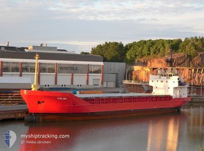
The vessel AMIRA (IMO: 8003943, MMSI: 271055026) is a General Cargo that was built in 1981 ( 43 År gammal ). It's sailing under the flag of [TR] Turkey.
In this page you can find informations about the vessels current position, last detected port calls, and current voyage information. If the vessels is not in coverage by AIS you will find the latest position.
The current position of AMIRA is detected by our AIS receivers and we are not responsible for the reliability of the data. The last position was recorded while the vessel was in Coverage by the Ais receivers of our vessel tracking app.
The current draught of AMIRA as reported by AIS is 6.2 meters
Weather
| Temperature | 21.9°C / 71.42°F |
|---|---|
| Wind Speed | 12 knots |
| Direction | 328° NNW |
| Pressure | 1008.6 hPa |
| Humidity | 62 % |
| Cloud Coverage | 94 % |
Featured Company
Most Visited Ports (Last year)
| Port | Arrivals | |
|---|---|---|
| 34 | ||
| 13 | ||
| 2 | ||
| 1 |
Last Trips
| Origin | Departure | Destination | Arrival | Distance | |
|---|---|---|---|---|---|
| 2024-04-04 21:16 | 2024-04-16 22:03 | 482.74 nm | |||
| 2024-02-13 00:47 | 2024-04-04 01:06 | 984.02 nm |
Events
| Tid | Event | Detaljer | Position / Dest | Information |
|---|---|---|---|---|
| 2024-05-11 12:04 | Status ändrad | Default Under way using engine |
35.88761 / 34.24018
KALECIK
|
Fart: 7.7 kn Kurs: 116.8° |
| 2024-05-11 11:50 | UTANFÖR täckningsområde |
35.90037 / 34.20711
Mediterranean Sea - Eastern Basin
KALECIK
|
Fart: 7.7 kn Kurs: 116.8° |
|
| 2024-05-11 11:47 | Byter havsområde | Cypriote part of the Mediterranean Sea - Eastern Basin Turkish part of the Mediterranean Sea - Eastern Basin |
35.90315 / 34.19982
Mediterranean Sea - Eastern Basin
KALECIK
|
Fart: 7.7 kn Kurs: 114.8° |
| 2024-05-11 11:47 | Status ändrad | Under way using engine Default |
35.90315 / 34.19982
KALECIK
|
Fart: 7 kn Kurs: 117° |
| 2024-05-11 11:42 | Status ändrad | Default Under way using engine |
35.90667 / 34.18500
KALECIK
|
Fart: 7.8 kn Kurs: 116.6° |
| 2024-05-11 07:55 | Djupgående ändrat | 6.2 3 |
36.13521 / 33.65884
KALECIK
|
Fart: 8.5 kn Kurs: 159.5° |
| 2024-05-11 07:55 | Destination ändrad | KALECIK YESILOVACIK |
36.13521 / 33.65884
KALECIK
|
Fart: 8.5 kn Kurs: 159.5° |
| 2024-05-11 07:55 | ETA ändrat | 2024/05/11 23:00 2024/05/09 19:30 |
36.13521 / 33.65884
KALECIK
|
Fart: 8.5 kn Kurs: 159.5° |
| 2024-05-11 07:49 | Status ändrad | Under way using engine Default |
36.14607 / 33.65368
YESILOVACIK
|
Fart: 8 kn Kurs: 159° |
| 2024-05-11 07:31 | Status ändrad | Default Moored |
36.17873 / 33.65328
YESILOVACIK
|
Fart: 0.2 kn Kurs: 511° |