
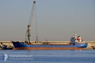
ALTAY
Bulk Carrier
Current Trip
IT QOS
| Time Travelled | 6 days |
|---|---|
| Remaining Time | --- |
| Distance Travelled | 81.64 nm |
| Remaining Distance | --- |
| AVG Speed | 8.5 Knop |
| MAX Speed | 11.9 Knop |
| AVG Wind | 19.4 knots |
| MAX Wind | 33 knots |
| MIN Temp | 7.7°C / 45.86°F |
| MAX Temp | 16.8°C / 62.24°F |
| Djupgående | 6.5 m |
| Position mottagen | 13 d sen |
Current Position
| Longitud | --- |
|---|---|
| Latitude | --- |
| Status | Under way using engine |
| Fart | 9.3 Knop |
| Kurs | 300.3° |
| Område | Mediterranean Sea - Western Basin |
| Station | T-AIS |
| Position mottagen | 13 d sen |
Info
Information
The current position of ALTAY is in Mediterranean Sea - Western Basin with coordinates 37.67198° / 11.82724° as reported on 2024-12-12 08:50 by AIS to our vessel tracker app. The vessel's current speed is 9.3 Knop
The vessel ALTAY (IMO: 9349992, MMSI: 538004502) is a Bulk Carrier that was built in 2006 ( 18 År gammal ). It's sailing under the flag of [MH] Marshall Is.
In this page you can find informations about the vessels current position, last detected port calls, and current voyage information. If the vessels is not in coverage by AIS you will find the latest position.
The current position of ALTAY is detected by our AIS receivers and we are not responsible for the reliability of the data. The last position was recorded while the vessel was in Coverage by the Ais receivers of our vessel tracking app.
The current draught of ALTAY as reported by AIS is 6.5 meters
Weather
| Temperature | 7.8°C / 46.04°F |
|---|---|
| Wind Speed | 7 knots |
| Direction | 21° NNE |
| Pressure | 1024.5 hPa |
| Humidity | 72.7 % |
| Cloud Coverage | 3 % |
Featured Company
Last Port Calls
| Port | Arrival | Departure | Time In Port |
|---|---|---|---|
| 2024-12-19 15:04 | |||
| 2024-11-26 14:16 | 2024-11-27 06:55 | 16 h | |
| 2024-11-17 08:18 | 2024-11-19 22:30 | 2 d | |
| 2024-11-04 14:20 | 2024-11-12 14:47 | 8 d | |
| 2024-10-31 06:06 | 2024-11-03 08:24 | 3 d | |
| 2024-10-23 22:43 | 2024-10-24 00:00 | 1 h | |
| 2024-10-18 18:10 | 2024-10-22 04:50 | 3 d | |
| 2024-10-17 05:43 | 2024-10-18 17:54 | 1 d | |
| 2024-10-15 13:25 | 2024-10-16 05:41 | 16 h | |
| 2024-10-12 15:33 | 2024-10-14 11:05 | 1 d |
Last Trips
| Origin | Departure | Destination | Arrival | Distance | |
|---|---|---|---|---|---|
| 2024-11-20 01:30 | 2024-11-26 16:16 | 618.81 nm | |||
| 2024-11-12 15:47 | 2024-11-17 11:18 | 1002.90 nm | |||
| 2024-11-03 09:24 | 2024-11-04 15:20 | 22.06 nm | |||
| 2024-10-24 03:00 | 2024-10-31 07:06 | 1211.40 nm | |||
| 2024-10-22 07:50 | 2024-10-24 01:43 | 319.21 nm | |||
| 2024-10-18 20:54 | 2024-10-18 21:10 | 1.24 nm | |||
| 2024-10-16 08:41 | 2024-10-17 08:43 | 60.54 nm | |||
| 2024-10-14 14:05 | 2024-10-15 16:25 | 220.33 nm | |||
| 2024-10-09 22:53 | 2024-10-12 18:33 | 473.14 nm | |||
| 2024-10-05 22:01 | 2024-10-07 12:37 | 417.91 nm |
Events
| Tid | Event | Detaljer | Position / Dest | Information |
|---|---|---|---|---|
| 2024-12-24 10:56 | STARTAR förflyttning | 7.83 nm, South East of CALASETTA |
39.01143 / 8.48018
IT QOS
|
Fart: 4.3 kn Kurs: 183° |
| 2024-12-23 14:58 | STOPPAR förflyttning | 7.74 nm, South East of CALASETTA |
39.01476 / 8.48217
IT QOS
|
Fart: 0.2 kn Kurs: 307° |
| 2024-12-23 09:55 | STOPPAR förflyttning | 7.4 nm, South East of CALASETTA |
39.01870 / 8.47705
IT QOS
|
Fart: Kurs: 316° |
| 2024-12-23 09:32 | STARTAR förflyttning | 7.83 nm, South East of CALASETTA |
39.01054 / 8.47867
IT QOS
|
Fart: 3.6 kn Kurs: 345° |
| 2024-12-23 08:06 | STOPPAR förflyttning | 7.74 nm, South East of CALASETTA |
39.01252 / 8.47863
IT QOS
|
Fart: 0.3 kn Kurs: 318° |
| 2024-12-23 06:46 | STARTAR förflyttning | 7.76 nm, South East of CALASETTA |
39.01019 / 8.47551
IT QOS
|
Fart: 3.6 kn Kurs: 352° |
| 2024-12-20 13:33 | STOPPAR förflyttning | 7.47 nm, South East of CALASETTA |
39.01449 / 8.47269
IT QOS
|
Fart: 0.1 kn Kurs: 316° |
| 2024-12-20 12:44 | STARTAR förflyttning | 7.72 nm, South East of CALASETTA |
39.01617 / 8.48360
IT QOS
|
Fart: 3.7 kn Kurs: 285° |
| 2024-12-20 08:28 | STOPPAR förflyttning | 6.99 nm, South East of CALASETTA |
39.02506 / 8.47278
IT QOS
|
Fart: 0.3 kn Kurs: 299° |
| 2024-12-20 07:42 | STARTAR förflyttning | 7.63 nm, South East of CALASETTA |
39.02119 / 8.48785
IT QOS
|
Fart: 3.3 kn Kurs: 320° |