
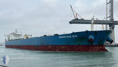
ADVANTAGE SUN
Crude Oil Tanker
Current Trip
ESLPA>NGODU
| Time Travelled | 9 days |
|---|---|
| Remaining Time | --- |
| Distance Travelled | 2915.52 nm |
| Remaining Distance | --- |
| AVG Speed | 13.1 Knop |
| MAX Speed | 15.2 Knop |
| AVG Wind | 13.4 knots |
| MAX Wind | 37.8 knots |
| MIN Temp | 12.2°C / 53.96°F |
| MAX Temp | 29.1°C / 84.38°F |
| Djupgående | 9.4 m |
| Position mottagen | 1 d sen |
Current Position
| Longitud | -18.98045° |
|---|---|
| Latitude | 9.60582° |
| Status | Under way using engine |
| Fart | 14 Knop |
| Kurs | 137.5° |
| Område | North Atlantic Ocean |
| Station | T-AIS |
| Position mottagen | 1 d sen |
Info
Information
The current position of ADVANTAGE SUN is in North Atlantic Ocean with coordinates 9.60582° / -18.98045° as reported on 2024-04-29 12:46 by AIS to our vessel tracker app. The vessel's current speed is 14 Knop
The vessel ADVANTAGE SUN (IMO: 9513141, MMSI: 538006201) is a Crude Oil Tanker that was built in 2012 ( 12 År gammal ). It's sailing under the flag of [MH] Marshall Is.
In this page you can find informations about the vessels current position, last detected port calls, and current voyage information. If the vessels is not in coverage by AIS you will find the latest position.
The current position of ADVANTAGE SUN is detected by our AIS receivers and we are not responsible for the reliability of the data. The last position was recorded while the vessel was in Coverage by the Ais receivers of our vessel tracking app.
The current draught of ADVANTAGE SUN as reported by AIS is 9.4 meters
Weather
| Temperature | 28.6°C / 83.48°F |
|---|---|
| Wind Speed | 7 knots |
| Direction | 234° SW |
| Pressure | 1010.3 hPa |
| Humidity | 76.3 % |
| Cloud Coverage | 83 % |
Featured Company
Last Port Calls
| Port | Arrival | Departure | Time In Port |
|---|---|---|---|
| 2024-04-19 09:24 | 2024-04-21 18:18 | 2 d | |
| 2024-03-19 00:19 | 2024-03-20 23:17 | 1 d | |
| 2024-03-12 17:50 | 2024-03-14 16:49 | 1 d | |
| 2024-03-08 15:06 |
Events
| Tid | Event | Detaljer | Position / Dest | Information |
|---|---|---|---|---|
| 2024-04-29 12:51 | Status ändrad | Default Under way using engine |
9.59131 / -18.96723
ESLPA>NGODU
|
Fart: 14 kn Kurs: 137.5° |
| 2024-04-29 12:46 | Byter havsområde | Guinea Bissau part of the North Atlantic Ocean Senegalese part of the North Atlantic Ocean |
9.60582 / -18.98045
North Atlantic Ocean
ESLPA>NGODU
|
Fart: 14 kn Kurs: 137.5° |
| 2024-04-29 12:46 | Status ändrad | Under way using engine Default |
9.60582 / -18.98045
ESLPA>NGODU
|
Fart: 13 kn Kurs: 137° |
| 2024-04-29 12:46 | UTANFÖR täckningsområde |
9.60582 / -18.98045
North Atlantic Ocean
ESLPA>NGODU
|
Fart: 14 kn Kurs: 137.5° |
|
| 2024-04-29 12:40 | I täckningsområde |
9.60582 / -18.98045
North Atlantic Ocean
ESLPA>NGODU
|
Fart: 14 kn Kurs: 137.5° |
|
| 2024-04-29 02:46 | Status ändrad | Default Under way using engine |
11.66500 / -19.50667
ESLPA>NGODU
|
Fart: 12.7 kn Kurs: 179.5° |
| 2024-04-29 02:29 | UTANFÖR täckningsområde |
11.74742 / -19.50628
North Atlantic Ocean
ESLPA>NGODU
|
Fart: 12.7 kn Kurs: 179.5° |
|
| 2024-04-29 01:03 | Status ändrad | Under way using engine Default |
12.03820 / -19.50683
ESLPA>NGODU
|
Fart: 13 kn Kurs: 180° |
| 2024-04-29 00:54 | I täckningsområde |
12.03820 / -19.50683
North Atlantic Ocean
ESLPA>NGODU
|
Fart: 13.1 kn Kurs: 179.7° |
|
| 2024-04-28 23:57 | UTANFÖR täckningsområde |
12.28046 / -19.50687
North Atlantic Ocean
ESLPA>NGODU
|
Fart: 13.2 kn Kurs: 180° |