
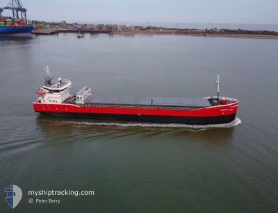
ADAMAS
General Cargo
Current Trip
| Time Travelled | 10 days |
|---|---|
| Remaining Time | 15 h, 50 mins |
| Distance Travelled | 1956.96 nm |
| Remaining Distance | 185.81 nm |
| AVG Speed | 8.8 Knop |
| MAX Speed | 13 Knop |
| AVG Wind | 12.3 knots |
| MAX Wind | 26.7 knots |
| MIN Temp | 4.8°C / 40.64°F |
| MAX Temp | 11.7°C / 53.06°F |
| Djupgående | 5.4 m |
| Position mottagen | 11 m sen |
Current Position
| Longitud | --- |
|---|---|
| Latitude | --- |
| Status | Under way using engine |
| Fart | 11.5 Knop |
| Kurs | 39.3° |
| Område | North Sea |
| Station | T-AIS |
| Position mottagen | 11 m sen |
Info
Information
The current position of ADAMAS is in North Sea with coordinates 51.46803° / 2.14821° as reported on 2025-03-07 07:15 by AIS to our vessel tracker app. The vessel's current speed is 11.5 Knop and is heading at the port of NEW HOLLAND. The estimated time of arrival as calculated by MyShipTracking vessel tracking app is 2025-03-07 23:16 LT
The vessel ADAMAS (IMO: 9489558, MMSI: 246667000) is a General Cargo that was built in 2010 ( 15 År gammal ). It's sailing under the flag of [NL] Netherlands.
In this page you can find informations about the vessels current position, last detected port calls, and current voyage information. If the vessels is not in coverage by AIS you will find the latest position.
The current position of ADAMAS is detected by our AIS receivers and we are not responsible for the reliability of the data. The last position was recorded while the vessel was in Coverage by the Ais receivers of our vessel tracking app.
The current draught of ADAMAS as reported by AIS is 5.4 meters
Weather
| Temperature | 9.2°C / 48.56°F |
|---|---|
| Wind Speed | 13 knots |
| Direction | 174° S |
| Pressure | 1013.8 hPa |
| Humidity | 85.9 % |
| Cloud Coverage | 8 % |
Featured Company
Events
| Tid | Event | Detaljer | Position / Dest | Information |
|---|---|---|---|---|
| 2025-03-07 07:17 | Status ändrad | Default Under way using engine |
51.47344 / 2.15530
NEW HOLLAND
|
Fart: 11.5 kn Kurs: 39.3° |
| 2025-03-07 06:54 | Upptäckt i hav | French part of the North Sea |
51.41534 / 2.07883
North Sea
NEW HOLLAND
|
Fart: 11.3 kn Kurs: 40.2° |
| 2025-03-07 04:37 | Byter havsområde | United Kingdom part of the North Sea French part of the North Sea |
51.06326 / 1.61906
North Sea
NEW HOLLAND
|
Fart: 12.7 kn Kurs: 48° |
| 2025-03-07 04:25 | Byter havsområde | French part of the North Sea French part of the English Channel |
51.03401 / 1.56808
North Sea
NEW HOLLAND
|
Fart: 12.5 kn Kurs: 45.5° |
| 2025-03-07 03:28 | Status ändrad | Under way using engine Default |
50.87212 / 1.41234
NEW HOLLAND
|
Fart: 12 kn Kurs: 14° |
| 2025-03-07 03:26 | Status ändrad | Default Under way using engine |
50.86512 / 1.40939
NEW HOLLAND
|
Fart: 11.5 kn Kurs: 16.4° |
| 2025-03-07 02:59 | Status ändrad | Under way using engine Default |
50.78389 / 1.37440
NEW HOLLAND
|
Fart: 11.1 kn Kurs: 20° |
| 2025-03-07 02:50 | Status ändrad | Default Under way using engine |
50.75561 / 1.35879
NEW HOLLAND
|
Fart: 11 kn Kurs: 18.6° |
| 2025-03-07 02:40 | Byter havsområde | French part of the English Channel United Kingdom part of the English Channel |
50.72630 / 1.34224
English Channel
NEW HOLLAND
|
Fart: 10.8 kn Kurs: 19° |
| 2025-03-07 02:40 | Status ändrad | Under way using engine Default |
50.72630 / 1.34224
NEW HOLLAND
|
Fart: 10.9 kn Kurs: 20° |