
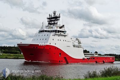
ABEILLE NORMANDIE
Anchor Handling Vessel
Current Trip
NAVY ORDERS
| Time Travelled | 16 h, 47 mins |
|---|---|
| Remaining Time | --- |
| Distance Travelled | 56.92 nm |
| Remaining Distance | --- |
| AVG Speed | 6.6 Knop |
| MAX Speed | 13.8 Knop |
| AVG Wind | 9 knots |
| MAX Wind | 10.8 knots |
| MIN Temp | 12.7°C / 54.86°F |
| MAX Temp | 14.9°C / 58.82°F |
| Djupgående | 7.1 m |
| Position mottagen | 3 m sen |
Current Position
| Longitud | 2.32760° |
|---|---|
| Latitude | 51.06506° |
| Status | Under way using engine |
| Fart | 5.9 Knop |
| Kurs | 82.1° |
| Område | North Sea |
| Station | T-AIS |
| Position mottagen | 3 m sen |
Info
Information
The current position of ABEILLE NORMANDIE is in North Sea with coordinates 51.06506° / 2.32760° as reported on 2024-05-14 14:08 by AIS to our vessel tracker app. The vessel's current speed is 5.9 Knop
The vessel ABEILLE NORMANDIE (IMO: 9442421, MMSI: 228415800) is a Anchor Handling Vessel that was built in 2010 ( 14 År gammal ). It's sailing under the flag of [FR] France.
In this page you can find informations about the vessels current position, last detected port calls, and current voyage information. If the vessels is not in coverage by AIS you will find the latest position.
The current position of ABEILLE NORMANDIE is detected by our AIS receivers and we are not responsible for the reliability of the data. The last position was recorded while the vessel was in Coverage by the Ais receivers of our vessel tracking app.
The current draught of ABEILLE NORMANDIE as reported by AIS is 7.1 meters
Weather
| Temperature | 12.7°C / 54.86°F |
|---|---|
| Wind Speed | 7 knots |
| Direction | 193° SSW |
| Pressure | 1003.9 hPa |
| Humidity | 94.3 % |
| Cloud Coverage | 100 % |
Featured Company
Last Port Calls
| Port | Arrival | Departure | Time In Port |
|---|---|---|---|
| 2024-05-13 13:44 | 2024-05-13 21:25 | 7 h | |
| 2024-05-13 09:53 | 2024-05-13 13:04 | 3 h | |
| 2024-05-11 11:02 | 2024-05-11 15:42 | 4 h | |
| 2024-05-06 10:08 | 2024-05-06 14:45 | 4 h | |
| 2024-05-05 09:05 | 2024-05-06 04:00 | 18 h | |
| 2024-05-01 20:16 | 2024-05-04 05:09 | 2 d | |
| 2024-04-30 08:07 | 2024-05-01 03:22 | 19 h | |
| 2024-04-29 12:20 | 2024-04-30 03:41 | 15 h | |
| 2024-04-27 12:21 | 2024-04-29 06:17 | 1 d | |
| 2024-04-26 15:21 | 2024-04-27 04:54 | 13 h |
Most Visited Ports (Last year)
| Port | Arrivals | |
|---|---|---|
| 115 | ||
| 7 | ||
| 3 |
Last Trips
| Origin | Departure | Destination | Arrival | Distance | |
|---|---|---|---|---|---|
| 2024-05-13 15:04 | 2024-05-13 15:44 | 8.55 nm | |||
| 2024-05-11 17:42 | 2024-05-13 11:53 | 147.25 nm | |||
| 2024-05-06 16:45 | 2024-05-11 13:02 | 55.84 nm | |||
| 2024-05-06 06:00 | 2024-05-06 12:08 | 28.49 nm | |||
| 2024-05-04 07:09 | 2024-05-05 11:05 | 64.45 nm | |||
| 2024-05-01 05:22 | 2024-05-01 22:16 | 166.24 nm | |||
| 2024-04-30 05:41 | 2024-04-30 10:07 | 33.83 nm | |||
| 2024-04-29 08:17 | 2024-04-29 14:20 | 38.71 nm | |||
| 2024-04-27 06:54 | 2024-04-27 14:21 | 45.12 nm | |||
| 2024-04-26 13:11 | 2024-04-26 17:21 | 24.68 nm |
Events
| Tid | Event | Detaljer | Position / Dest | Information |
|---|---|---|---|---|
| 2024-05-14 13:30 | Status ändrad | Under way using engine Default |
51.05853 / 2.20929
NAVY ORDERS
|
Fart: 13.8 kn Kurs: 83° |
| 2024-05-14 13:29 | Status ändrad | Default Under way using engine |
51.05802 / 2.20242
NAVY ORDERS
|
Fart: 13.8 kn Kurs: 83° |
| 2024-05-14 12:13 | STARTAR förflyttning | 7.97 nm, North East of CALAIS |
51.08479 / 1.95298
NAVY ORDERS
|
Fart: 3.2 kn Kurs: 154° |
| 2024-05-14 12:04 | STOPPAR förflyttning | 8.11 nm, North East of CALAIS |
51.08787 / 1.95155
NAVY ORDERS
|
Fart: 0.3 kn Kurs: 71° |
| 2024-05-14 11:00 | STARTAR förflyttning | 9.59 nm, North East of CALAIS |
51.09827 / 1.99866
NAVY ORDERS
|
Fart: 3.4 kn Kurs: 124° |
| 2024-05-14 10:16 | STOPPAR förflyttning | 9.76 nm, North East of CALAIS |
51.09782 / 2.00722
NAVY ORDERS
|
Fart: 0.2 kn Kurs: 91° |
| 2024-05-14 10:12 | Status ändrad | Under way using engine Default |
51.09999 / 2.01271
NAVY ORDERS
|
Fart: 0.9 kn Kurs: 32° |
| 2024-05-14 10:01 | Status ändrad | Default Under way using engine |
51.09947 / 2.00960
NAVY ORDERS
|
Fart: 1.6 kn Kurs: 227° |
| 2024-05-14 09:18 | STARTAR förflyttning | 9.66 nm, North East of CALAIS |
51.09313 / 2.01225
NAVY ORDERS
|
Fart: 3.1 kn Kurs: 51° |
| 2024-05-14 09:07 | Status ändrad | Under way using engine Default |
51.09060 / 2.01489
NAVY ORDERS
|
Fart: 0.9 kn Kurs: 136° |