

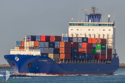
A LA MARINE
Container Ship

Current Trip
| Time Travelled | 17 h, 21 mins |
|---|---|
| Remaining Time | --- |
| Distance Travelled | 58.09 nm |
| Remaining Distance | --- |
| AVG Speed | 7.4 Knop |
| MAX Speed | 8.4 Knop |
| AVG Wind | 5.5 knots |
| MAX Wind | 10.5 knots |
| MIN Temp | 9.4°C / 48.92°F |
| MAX Temp | 14.2°C / 57.56°F |
| Djupgående | 9.8 m |
| Position mottagen | 2 m sen |
Current Position
| Longitud | --- |
|---|---|
| Latitude | --- |
| Status | At anchor |
| Fart | 0.1 Knop |
| Kurs | 20° |
| Område | Tyrrhenian Sea |
| Station | T-AIS |
| Position mottagen | 2 m sen |
Information
The current position of A LA MARINE is in Tyrrhenian Sea with coordinates 44.04051° / 9.90204° as reported on 2025-03-29 17:41 by AIS to our vessel tracker app. The vessel's current speed is 0.1 Knop
The vessel A LA MARINE (IMO: 9386524, MMSI: 205795000) is a Container Ship that was built in 2009 ( 16 År gammal ). It's sailing under the flag of [BE] Belgium.
In this page you can find informations about the vessels current position, last detected port calls, and current voyage information. If the vessels is not in coverage by AIS you will find the latest position.
The current position of A LA MARINE is detected by our AIS receivers and we are not responsible for the reliability of the data. The last position was recorded while the vessel was in Coverage by the Ais receivers of our vessel tracking app.
The current draught of A LA MARINE as reported by AIS is 9.8 meters
Weather
| Temperature | 13.4°C / 56.12°F |
|---|---|
| Wind Speed | 9 knots |
| Direction | 347° NNW |
| Pressure | 1004.5 hPa |
| Humidity | 75.3 % |
| Cloud Coverage | 100 % |


Featured Company
Last Port Calls
| Port | Arrival | Departure | Time In Port |
|---|---|---|---|
| 2025-03-28 04:56 | 2025-03-29 01:22 | 20 h | |
| 2025-03-26 05:24 | 2025-03-26 19:37 | 14 h | |
| 2025-03-21 19:54 | 2025-03-23 00:30 | 1 d | |
| 2025-03-20 08:32 | 2025-03-20 21:59 | 13 h | |
| 2025-03-15 12:40 | 2025-03-18 14:04 | 3 d | |
| 2025-03-03 14:42 | 2025-03-04 05:43 | 15 h | |
| 2025-03-02 05:49 | 2025-03-03 09:48 | 1 d | |
| 2025-02-27 13:41 | 2025-02-28 08:23 | 18 h | |
| 2025-02-24 16:40 | 2025-02-25 07:00 | 14 h | |
| 2025-02-13 15:09 | 2025-02-21 07:01 | 7 d |
Most Visited Ports (Last year)
| Port | Arrivals | |
|---|---|---|
| 12 | ||
| 12 | ||
| 11 | ||
| 11 | ||
| 10 | ||
| 9 |
Last Trips
| Origin | Departure | Destination | Arrival | Distance | |
|---|---|---|---|---|---|
| 2025-03-26 19:37 | 2025-03-28 04:56 | 247.88 nm | |||
| 2025-03-23 00:30 | 2025-03-26 05:24 | 1028.24 nm | |||
| 2025-03-20 21:59 | 2025-03-21 19:54 | 268.42 nm | |||
| 2025-03-18 14:04 | 2025-03-20 08:32 | 548.65 nm | |||
| 2025-03-04 05:43 | 2025-03-15 12:40 | 1291.84 nm | |||
| 2025-03-03 09:48 | 2025-03-03 14:42 | 49.28 nm | |||
| 2025-02-28 08:23 | 2025-03-02 05:49 | 361.72 nm | |||
| 2025-02-25 07:00 | 2025-02-27 13:41 | 336.73 nm | |||
| 2025-02-21 07:01 | 2025-02-24 16:40 | 344.64 nm | |||
| 2025-02-08 18:58 | 2025-02-13 15:09 | 224.47 nm |
Events
| Tid | Event | Detaljer | Position / Dest | Information |
|---|---|---|---|---|
| 2025-03-29 09:59 | Status ändrad | At anchor Default |
44.04115 / 9.90554
ITSPE
|
Fart: 0.4 kn Kurs: 285° |
| 2025-03-29 09:56 | Status ändrad | Default At anchor |
44.04142 / 9.90571
ITSPE
|
Fart: 0.4 kn Kurs: 279° |
| 2025-03-29 07:57 | Status ändrad | At anchor Under way using engine |
44.04066 / 9.90442
ITSPE
|
Fart: 0.9 kn Kurs: 338° |
| 2025-03-29 07:50 | STOPPAR förflyttning | 2.95 nm, East of PORTO VENERE |
44.04196 / 9.90405
ITSPE
|
Fart: 0.3 kn Kurs: 320° |
| 2025-03-29 06:53 | Status ändrad | Under way using engine Default |
43.95627 / 9.90942
ITSPE
|
Fart: 7.7 kn Kurs: 86° |
| 2025-03-29 06:47 | Status ändrad | Default Under way using engine |
43.95538 / 9.89150
ITSPE
|
Fart: 7.6 kn Kurs: 85.2° |
| 2025-03-29 06:40 | Status ändrad | Under way using engine Default |
43.95429 / 9.87051
ITSPE
|
Fart: 7.7 kn Kurs: 102° |
| 2025-03-29 06:27 | Status ändrad | Default Under way using engine |
43.95712 / 9.83511
ITSPE
|
Fart: 7.7 kn Kurs: 102.1° |
| 2025-03-29 06:25 | Byter havsområde | Italian part of the Tyrrhenian Sea Italian part of the Ligurian Sea |
43.95815 / 9.82836
Tyrrhenian Sea
ITSPE
|
Fart: 7.7 kn Kurs: 102.1° |
| 2025-03-29 06:20 | Status ändrad | Under way using engine Default |
43.96045 / 9.81353
ITSPE
|
Fart: 7.8 kn Kurs: 111° |