
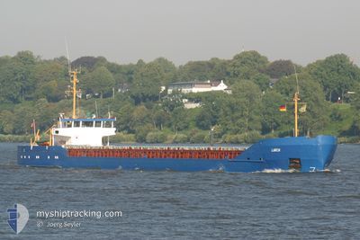
ZAMZAM I
General Cargo
Current Trip
| Time Travelled | 11 days |
|---|---|
| Remaining Time | --- |
| Distance Travelled | 517.61 nm |
| Remaining Distance | --- |
| AVG Speed | 8.1 Knopen |
| MAX Speed | 9.4 Knopen |
| AVG Wind | 10.1 knots |
| MAX Wind | 20 knots |
| MIN Temp | 22.5°C / 72.5°F |
| MAX Temp | 28.7°C / 83.66°F |
| Diepgang | 3.8 M |
| Positie ontvangen | 4 d geleden |
Current Position
| Lengtegraad | 27.58436° |
|---|---|
| Breedtegraat | 37.25333° |
| Status | At anchor |
| Snelheid | |
| Koers | --- |
| Gebied | Aegean Sea |
| Station | T-AIS |
| Positie ontvangen | 4 d geleden |
Info
Information
The current position of ZAMZAM I is in Aegean Sea with coordinates 37.25333° / 27.58436° as reported on 2024-09-06 10:18 by AIS to our vessel tracker app. The vessel's current speed is 0 Knopen and is heading at the port of GULLUK. The estimated time of arrival as calculated by MyShipTracking vessel tracking app is 2024-09-02 08:00 LT
The vessel ZAMZAM I (IMO: 8415689, MMSI: 341797000) is a General Cargo that was built in 1984 ( 40 Jaar oud ). It's sailing under the flag of [KN] St Kitts Nevis.
In this page you can find informations about the vessels current position, last detected port calls, and current voyage information. If the vessels is not in coverage by AIS you will find the latest position.
The current position of ZAMZAM I is detected by our AIS receivers and we are not responsible for the reliability of the data. The last position was recorded while the vessel was in Coverage by the Ais receivers of our vessel tracking app.
The current draught of ZAMZAM I as reported by AIS is 3.8 meters
Weather
| Temperature | 30.5°C / 86.9°F |
|---|---|
| Wind Speed | 18 knots |
| Direction | 303° WNW |
| Pressure | 1009.2 hPa |
| Humidity | 46.5 % |
| Cloud Coverage | --- |
Featured Company
Last Port Calls
| Port | Arrival | Departure | Time In Port |
|---|---|---|---|
| 2024-08-26 04:36 | 2024-08-30 13:36 | 4 d | |
| 2024-08-22 07:42 | 2024-08-23 06:03 | 22 h | |
| 2024-08-15 16:57 | 2024-08-19 15:14 | 3 d | |
| 2024-08-12 04:55 | 2024-08-13 11:36 | 1 d | |
| 2024-08-03 18:02 | 2024-08-08 17:05 | 4 d | |
| 2024-07-22 13:59 | 2024-07-29 12:39 | 6 d | |
| 2024-07-19 02:54 | 2024-07-20 13:58 | 1 d | |
| 2024-07-09 10:58 | 2024-07-12 15:11 | 3 d | |
| 2024-07-01 02:22 | 2024-07-06 16:43 | 5 d |
Last Trips
| Origin | Departure | Destination | Arrival | Distance | |
|---|---|---|---|---|---|
| 2024-08-23 08:03 | 2024-08-26 07:36 | 252.35 nm | |||
| 2024-08-19 17:14 | 2024-08-22 09:42 | 92.72 nm | |||
| 2024-08-13 14:36 | 2024-08-15 18:57 | 262.39 nm | |||
| 2024-08-08 20:05 | 2024-08-12 07:55 | 494.03 nm | |||
| 2024-07-29 14:39 | 2024-08-03 21:02 | 489.54 nm | |||
| 2024-07-20 16:58 | 2024-07-22 15:59 | 649.29 nm | |||
| 2024-07-12 17:11 | 2024-07-19 05:54 | 366.31 nm | |||
| 2024-07-06 19:43 | 2024-07-09 12:58 | 505.51 nm | |||
| 2024-06-28 16:26 | 2024-07-01 05:22 | 527.13 nm |
Events
| Tijd | Evenement | Details | Positie / Bestemming | Info |
|---|---|---|---|---|
| 2024-09-06 10:18 | Buitenbereik |
37.25333 / 27.58436
Aegean Sea
|
Snelheid: Koers: 344° |
|
| 2024-09-06 09:54 | Binnenbereik |
37.25315 / 27.58480
Aegean Sea
|
Snelheid: Koers: 55° |
|
| 2024-09-04 09:36 | Buitenbereik |
37.25307 / 27.58487
Aegean Sea
|
Snelheid: Koers: 113° |
|
| 2024-09-04 09:36 | Binnenbereik |
37.25307 / 27.58487
Aegean Sea
|
Snelheid: Koers: 113° |
|
| 2024-09-02 08:06 | Stop beweging | 0.82 nm, West of GULLUK |
37.25332 / 27.58428
TR GUL
|
Snelheid: 0.2 kn Koers: -1° |
| 2024-09-02 05:02 | Status Changed | Default Under way using engine |
37.11143 / 27.19340
TR GUL
|
Snelheid: 9.1 kn Koers: 23.2° |
| 2024-09-02 04:57 | Buitenbereik |
37.09940 / 27.18551
Aegean Sea
TR GUL
|
Snelheid: 9.1 kn Koers: 23.2° |
|
| 2024-09-02 04:40 | Gevonden in zee | Turkish part of the Aegean Sea |
37.05837 / 27.16972
Aegean Sea
TR GUL
|
Snelheid: 8.9 kn Koers: 13° |
| 2024-09-02 04:40 | Status Changed | Under way using engine Default |
37.05837 / 27.16972
TR GUL
|
Snelheid: 8.6 kn Koers: 9° |
| 2024-09-02 04:20 | Status Changed | Default Under way using engine |
37.01271 / 27.15567
TR GUL
|
Snelheid: 8.5 kn Koers: 356.6° |