
WARRIOR
Cargo
Current Trip
GI GIB
| Time Travelled | 2 days |
|---|---|
| Remaining Time | --- |
| Distance Travelled | 453.49 nm |
| Remaining Distance | --- |
| AVG Speed | 9.3 Knopen |
| MAX Speed | 13 Knopen |
| AVG Wind | 19.3 knots |
| MAX Wind | 39 knots |
| MIN Temp | 6°C / 42.8°F |
| MAX Temp | 17.1°C / 62.78°F |
| Diepgang | 11.3 M |
| Positie ontvangen | 1 d geleden |
Current Position
| Lengtegraad | --- |
|---|---|
| Breedtegraat | --- |
| Status | Under way using engine |
| Snelheid | 11.1 Knopen |
| Koers | 78° |
| Gebied | Mediterranean Sea - Eastern Basin |
| Station | T-AIS |
| Positie ontvangen | 1 d geleden |
Info
Information
The current position of WARRIOR is in Mediterranean Sea - Eastern Basin with coordinates 35.95811° / 29.80130° as reported on 2026-04-02 05:46 by AIS to our vessel tracker app. The vessel's current speed is 11.1 Knopen
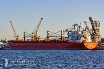
The vessel WARRIOR (IMO: 9605865, MMSI: 311036300) is a Cargo It's sailing under the flag of [BS] Bahamas.
In this page you can find informations about the vessels current position, last detected port calls, and current voyage information. If the vessels is not in coverage by AIS you will find the latest position.
The current position of WARRIOR is detected by our AIS receivers and we are not responsible for the reliability of the data. The last position was recorded while the vessel was in Coverage by the Ais receivers of our vessel tracking app.
The current draught of WARRIOR as reported by AIS is 11.3 meters
Weather
| Temperature | 8.9°C / 48.02°F |
|---|---|
| Wind Speed | 2 knots |
| Direction | 152° SSE |
| Pressure | 1010.6 hPa |
| Humidity | 71.1 % |
| Cloud Coverage | 24 % |
Featured Company
Most Visited Ports (Last year)
| Port | Arrivals | |
|---|---|---|
| 2 | ||
| 1 | ||
| 1 | ||
| 1 | ||
| 1 | ||
| 1 |
Last Trips
| Origin | Departure | Destination | Arrival | Distance | |
|---|---|---|---|---|---|
| 2026-03-25 13:36 | 2026-03-26 13:05 | 252.51 nm | |||
| 2026-01-12 23:22 | 2026-03-17 09:10 | 6008.21 nm |
Events
| Tijd | Evenement | Details | Positie / Bestemming | Info |
|---|---|---|---|---|
| 2026-04-02 13:29 | Stop beweging | --- |
36.82139 / 30.62437
GI GIB
|
Snelheid: 0.2 kn Koers: 155° |
| 2026-04-02 05:53 | Status Changed | Default Under way using engine |
35.96314 / 29.82904
GI GIB
|
Snelheid: 11.1 kn Koers: 78° |
| 2026-04-02 05:46 | Buitenbereik |
35.95811 / 29.80130
Mediterranean Sea - Eastern Basin
|
Snelheid: 11.1 kn Koers: 78° |
|
| 2026-04-02 05:26 | Wijzig zee gebeid | Turkish part of the Mediterranean Sea - Eastern Basin Greek part of the Mediterranean Sea - Eastern Basin |
35.94526 / 29.72553
Mediterranean Sea - Eastern Basin
|
Snelheid: 11.3 kn Koers: 79.2° |
| 2026-04-02 04:43 | Status Changed | Under way using engine Default |
35.91701 / 29.57819
GI GIB
|
Snelheid: 10.5 kn Koers: 79° |
| 2026-04-02 04:34 | Binnenbereik |
35.91701 / 29.57819
Mediterranean Sea - Eastern Basin
|
Snelheid: 10.2 kn Koers: 76.3° |
|
| 2026-04-02 00:25 | Status Changed | Default Under way using engine |
35.78690 / 28.59742
GI GIB
|
Snelheid: 11.4 kn Koers: 81.9° |
| 2026-04-01 23:53 | Buitenbereik |
35.77757 / 28.47348
Mediterranean Sea - Eastern Basin
|
Snelheid: 11.4 kn Koers: 81.9° |
|
| 2026-04-01 23:49 | Status Changed | Under way using engine Default |
35.77579 / 28.45902
GI GIB
|
Snelheid: 11 kn Koers: 85° |
| 2026-04-01 23:42 | Status Changed | Default Under way using engine |
35.77378 / 28.42945
GI GIB
|
Snelheid: 9.9 kn Koers: 83.2° |