
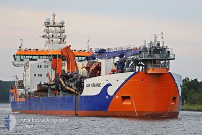
VOX ARIANE
Other Type
Current Trip
DREDGING-ELBE
| Time Travelled | 26 days |
|---|---|
| Remaining Time | --- |
| Distance Travelled | 4008.12 nm |
| Remaining Distance | --- |
| AVG Speed | 10.3 Knopen |
| MAX Speed | 18.6 Knopen |
| AVG Wind | 9.3 knots |
| MAX Wind | 29 knots |
| MIN Temp | -4.8°C / 23.36°F |
| MAX Temp | 10.7°C / 51.26°F |
| Diepgang | 7.8 M |
| Positie ontvangen | Nu |
Current Position
| Lengtegraad | --- |
|---|---|
| Breedtegraat | --- |
| Status | Under way using engine |
| Snelheid | 13.9 Knopen |
| Koers | 98.9° |
| Gebied | North Sea |
| Station | T-AIS |
| Positie ontvangen | Nu |
Info
Information
The current position of VOX ARIANE is in North Sea with coordinates 53.97460° / 8.46800° as reported on 2025-02-18 11:17 by AIS to our vessel tracker app. The vessel's current speed is 13.9 Knopen
The vessel VOX ARIANE (IMO: 9867085, MMSI: 245242000) is a Other Type It's sailing under the flag of [NL] Netherlands.
In this page you can find informations about the vessels current position, last detected port calls, and current voyage information. If the vessels is not in coverage by AIS you will find the latest position.
The current position of VOX ARIANE is detected by our AIS receivers and we are not responsible for the reliability of the data. The last position was recorded while the vessel was in Coverage by the Ais receivers of our vessel tracking app.
The current draught of VOX ARIANE as reported by AIS is 7.8 meters
Weather
| Temperature | -0.7°C / 30.74°F |
|---|---|
| Wind Speed | 8 knots |
| Direction | 137° SE |
| Pressure | 1030.8 hPa |
| Humidity | 55.7 % |
| Cloud Coverage | --- |
Featured Company
Last Port Calls
| Port | Arrival | Departure | Time In Port |
|---|---|---|---|
| 2025-01-22 11:06 | 2025-01-22 12:54 | 1 h | |
| 2025-01-17 16:51 | 2025-01-21 13:41 | 3 d | |
| 2025-01-11 04:55 | 2025-01-11 06:33 | 1 h | |
| 2025-01-11 03:36 | 2025-01-11 03:45 | 9 m | |
| 2025-01-10 21:04 | 2025-01-11 00:01 | 2 h | |
| 2025-01-10 19:59 | 2025-01-10 20:04 | 5 m | |
| 2025-01-10 14:09 | 2025-01-10 14:19 | 10 m | |
| 2025-01-10 08:56 | 2025-01-10 09:03 | 7 m | |
| 2025-01-10 03:57 | 2025-01-10 04:08 | 11 m | |
| 2025-01-09 23:04 | 2025-01-09 23:08 | 4 m |
Most Visited Ports (Last year)
| Port | Arrivals | |
|---|---|---|
| 246 | ||
| 109 | ||
| 86 | ||
| 56 | ||
| 11 | ||
| 4 |
Last Trips
| Origin | Departure | Destination | Arrival | Distance | |
|---|---|---|---|---|---|
| 2025-01-21 13:41 | 2025-01-22 11:06 | 126.76 nm | |||
| 2025-01-11 06:33 | 2025-01-17 16:51 | 708.06 nm | |||
| 2025-01-11 03:45 | 2025-01-11 04:55 | 8.60 nm | |||
| 2025-01-11 00:01 | 2025-01-11 03:36 | 39.38 nm | |||
| 2025-01-10 20:04 | 2025-01-10 21:04 | 9.18 nm | |||
| 2025-01-10 14:19 | 2025-01-10 19:59 | 52.53 nm | |||
| 2025-01-10 09:03 | 2025-01-10 14:09 | 39.47 nm | |||
| 2025-01-10 04:08 | 2025-01-10 08:56 | 37.69 nm | |||
| 2025-01-09 23:08 | 2025-01-10 03:57 | 41.22 nm | |||
| 2025-01-09 17:57 | 2025-01-09 23:04 | 40.97 nm |
Events
| Tijd | Evenement | Details | Positie / Bestemming | Info |
|---|---|---|---|---|
| 2025-02-18 11:08 | Start beweging | 11.87 nm, North West of CUXHAVEN |
53.97650 / 8.43062
DREDGING-ELBE
|
Snelheid: 5.8 kn Koers: 68.1° |
| 2025-02-18 10:58 | Stop beweging | 11.96 nm, North West of CUXHAVEN |
53.97617 / 8.42710
DREDGING-ELBE
|
Snelheid: 0.3 kn Koers: 94° |
| 2025-02-18 09:55 | Start beweging | 1.24 nm, North of CUXHAVEN |
53.88753 / 8.70152
DREDGING-ELBE
|
Snelheid: 3.1 kn Koers: 41° |
| 2025-02-18 09:18 | Stop beweging | 1.82 nm, North of CUXHAVEN |
53.89618 / 8.69290
DREDGING-ELBE
|
Snelheid: 0.3 kn Koers: 150° |
| 2025-02-18 09:09 | Start beweging | 1.2 nm, North of CUXHAVEN |
53.88690 / 8.70153
DREDGING-ELBE
|
Snelheid: 4.4 kn Koers: 145° |
| 2025-02-18 09:07 | Stop beweging | 1.09 nm, North of CUXHAVEN |
53.88528 / 8.70322
DREDGING-ELBE
|
Snelheid: 0.3 kn Koers: 140° |
| 2025-02-18 01:54 | Start beweging | 3.44 nm, North of NEUHAUS |
53.86070 / 9.02643
DREDGING-ELBE
|
Snelheid: 3.1 kn Koers: 253° |
| 2025-02-18 01:21 | Stop beweging | 3.63 nm, North of NEUHAUS |
53.86455 / 9.04155
DREDGING-ELBE
|
Snelheid: 0.3 kn Koers: 246° |
| 2025-02-18 01:13 | Start beweging | 3.46 nm, North of NEUHAUS |
53.86127 / 9.02903
DREDGING-ELBE
|
Snelheid: 3.4 kn Koers: 246° |
| 2025-02-18 01:10 | Stop beweging | 3.44 nm, North of NEUHAUS |
53.86053 / 9.02600
DREDGING-ELBE
|
Snelheid: 0.1 kn Koers: 243° |