
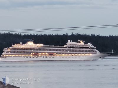
VIKING ORION
Passenger
Current Trip
| Time Travelled | 1 day |
|---|---|
| Remaining Time | 4 h, 6 mins |
| Distance Travelled | 395.06 nm |
| Remaining Distance | 71.17 nm |
| AVG Speed | 16.4 Knopen |
| MAX Speed | 21.6 Knopen |
| AVG Wind | 10.2 knots |
| MAX Wind | 21.3 knots |
| MIN Temp | 7°C / 44.6°F |
| MAX Temp | 10°C / 50°F |
| Diepgang | 6.8 M |
| Positie ontvangen | 15 d geleden |
Current Position
| Lengtegraad | -131.65748° |
|---|---|
| Breedtegraat | 55.18810° |
| Status | Under way using engine |
| Snelheid | 15.6 Knopen |
| Koers | 13.7° |
| Gebied | The Coastal Waters of Southeast Alaska and British Columbia |
| Station | T-AIS |
| Positie ontvangen | 15 d geleden |
Info
Information
The current position of VIKING ORION is in The Coastal Waters of Southeast Alaska and British Columbia with coordinates 55.18810° / -131.65748° as reported on 2024-05-16 16:21 by AIS to our vessel tracker app. The vessel's current speed is 15.6 Knopen and is heading at the port of KETCHIKAN. The estimated time of arrival as calculated by MyShipTracking vessel tracking app is 2024-06-01 13:58 LT
The vessel VIKING ORION (IMO: 9796250, MMSI: 257034130) is a Passenger It's sailing under the flag of [NO] Norway.
In this page you can find informations about the vessels current position, last detected port calls, and current voyage information. If the vessels is not in coverage by AIS you will find the latest position.
The current position of VIKING ORION is detected by our AIS receivers and we are not responsible for the reliability of the data. The last position was recorded while the vessel was in Coverage by the Ais receivers of our vessel tracking app.
The current draught of VIKING ORION as reported by AIS is 6.8 meters
Weather
| Temperature | 7.4°C / 45.32°F |
|---|---|
| Wind Speed | 3 knots |
| Direction | 149° SSE |
| Pressure | 1010.3 hPa |
| Humidity | 94.5 % |
| Cloud Coverage | 100 % |
Featured Company
Last Port Calls
| Port | Arrival | Departure | Time In Port |
|---|---|---|---|
| 2024-05-30 14:48 | 2024-05-31 01:24 | 10 h | |
| 2024-05-28 14:47 | 2024-05-29 04:00 | 13 h | |
| 2024-05-26 14:51 | 2024-05-26 23:39 | 8 h | |
| 2024-05-23 14:38 | 2024-05-26 00:58 | 2 d | |
| 2024-05-23 14:02 | 2024-05-23 14:06 | 3 m | |
| 2024-05-22 14:58 | 2024-05-22 23:34 | 8 h | |
| 2024-05-19 13:14 | 2024-05-20 01:42 | 12 h | |
| 2024-05-18 15:34 | 2024-05-19 01:37 | 10 h | |
| 2024-05-16 17:06 | 2024-05-17 01:22 | 8 h | |
| 2024-05-14 13:21 | 2024-05-15 02:24 | 13 h |
Last Trips
| Origin | Departure | Destination | Arrival | Distance | |
|---|---|---|---|---|---|
| 2024-05-28 20:00 | 2024-05-30 06:48 | 213.85 nm | |||
| 2024-05-26 15:39 | 2024-05-28 06:47 | 602.37 nm | |||
| 2024-05-25 16:58 | 2024-05-26 06:51 | 181.98 nm | |||
| 2024-05-23 06:06 | 2024-05-23 06:38 | 0.93 nm | |||
| 2024-05-22 15:34 | 2024-05-23 06:02 | 186.81 nm | |||
| 2024-05-19 17:42 | 2024-05-22 06:58 | 744.22 nm | |||
| 2024-05-18 17:37 | 2024-05-19 05:14 | 98.31 nm | |||
| 2024-05-16 17:22 | 2024-05-18 07:34 | 462.56 nm | |||
| 2024-05-14 19:24 | 2024-05-16 09:06 | 571.11 nm | |||
| 2024-05-12 14:06 | 2024-05-14 06:21 | 585.87 nm |
Events
| Tijd | Evenement | Details | Positie / Bestemming | Info |
|---|---|---|---|---|
| 2024-05-31 23:44 | Start beweging | 4.94 nm, North West of SITKA |
57.12012 / -135.39525
US KTN
|
Snelheid: 3.3 kn Koers: 158° |
| 2024-05-31 15:35 | Stop beweging | 4.75 nm, North West of SITKA |
57.11666 / -135.39500
US KTN
|
Snelheid: Koers: -1° |
| 2024-05-31 01:24 | Vertrekhaven |
|
58.26911 / -134.36145
US KTN
|
Snelheid: 7.2 kn Koers: 132° |
| 2024-05-31 01:08 | Start beweging |
58.28907 / -134.40512
[US] JUNEAU
|
Snelheid: 5.3 kn Koers: 142° |
|
| 2024-05-30 15:23 | Stop beweging |
58.29295 / -134.41168
[US] JUNEAU
|
Snelheid: 0.2 kn Koers: 49° |
|
| 2024-05-30 14:48 | Aankomsthaven |
|
58.27812 / -134.38182
[US] JUNEAU
|
Snelheid: 7.1 kn Koers: 312° |
| 2024-05-30 02:52 | Start beweging | 2.37 nm, North of HOONAH |
58.14860 / -135.42694
US KTN
|
Snelheid: 8.3 kn Koers: 39° |
| 2024-05-29 15:14 | Stop beweging | 1.96 nm, North of HOONAH |
58.14270 / -135.43509
US KTN
|
Snelheid: 0.2 kn Koers: 234° |
| 2024-05-29 04:00 | Start beweging | 0.47 nm, East of HAINES |
59.23017 / -135.41994
US KTN
|
Snelheid: 6.3 kn Koers: 90° |
| 2024-05-29 04:00 | Vertrekhaven |
|
59.23017 / -135.41994
US KTN
|
Snelheid: 0.7 kn Koers: 97° |