
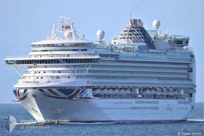
VENTURA
Passengers Ship
Current Trip
ESACE
| Time Travelled | 1 day |
|---|---|
| Remaining Time | --- |
| Distance Travelled | 422.73 nm |
| Remaining Distance | --- |
| AVG Speed | 17 Knopen |
| MAX Speed | 18.4 Knopen |
| AVG Wind | 12.4 knots |
| MAX Wind | 16 knots |
| MIN Temp | 17.8°C / 64.04°F |
| MAX Temp | 19.7°C / 67.46°F |
| Diepgang | 8.5 M |
| Positie ontvangen | 1 d geleden |
Current Position
| Lengtegraad | -13.53337° |
|---|---|
| Breedtegraat | 28.96261° |
| Status | Under way using engine |
| Snelheid | 3.4 Knopen |
| Koers | 359° |
| Gebied | North Atlantic Ocean |
| Station | T-AIS |
| Positie ontvangen | 1 d geleden |
Info
Information
The current position of VENTURA is in North Atlantic Ocean with coordinates 28.96261° / -13.53337° as reported on 2024-05-19 17:09 by AIS to our vessel tracker app. The vessel's current speed is 3.4 Knopen
The vessel VENTURA (IMO: 9333175, MMSI: 310562000) is a Passengers Ship that was built in 2008 ( 16 Jaar oud ). It's sailing under the flag of [BM] Bermuda.
In this page you can find informations about the vessels current position, last detected port calls, and current voyage information. If the vessels is not in coverage by AIS you will find the latest position.
The current position of VENTURA is detected by our AIS receivers and we are not responsible for the reliability of the data. The last position was recorded while the vessel was in Coverage by the Ais receivers of our vessel tracking app.
The current draught of VENTURA as reported by AIS is 8.5 meters
Weather
| Temperature | 18°C / 64.4°F |
|---|---|
| Wind Speed | 9 knots |
| Direction | 338° NNW |
| Pressure | 1018.1 hPa |
| Humidity | 65.8 % |
| Cloud Coverage | --- |
Featured Company
Last Port Calls
| Port | Arrival | Departure | Time In Port |
|---|---|---|---|
| 2024-05-19 07:14 | 2024-05-19 18:18 | 11 h | |
| 2024-05-18 07:08 | 2024-05-18 18:32 | 11 h | |
| 2024-05-17 07:24 | 2024-05-17 23:38 | 16 h | |
| 2024-05-16 08:06 | 2024-05-16 18:18 | 10 h | |
| 2024-05-15 07:14 | 2024-05-15 17:22 | 10 h | |
| 2024-05-11 04:57 | 2024-05-11 19:33 | 14 h | |
| 2024-05-10 11:14 | 2024-05-10 19:12 | 7 h | |
| 2024-05-10 08:11 | 2024-05-10 10:13 | 2 h | |
| 2024-05-08 06:48 | 2024-05-08 17:29 | 10 h | |
| 2024-05-07 07:11 | 2024-05-07 18:24 | 11 h |
Last Trips
| Origin | Departure | Destination | Arrival | Distance | |
|---|---|---|---|---|---|
| 2024-05-18 18:32 | 2024-05-19 07:14 | 121.92 nm | |||
| 2024-05-17 23:38 | 2024-05-18 07:08 | 84.11 nm | |||
| 2024-05-16 18:18 | 2024-05-17 07:24 | 119.92 nm | |||
| 2024-05-15 17:22 | 2024-05-16 08:06 | 242.68 nm | |||
| 2024-05-11 19:33 | 2024-05-15 07:14 | 1358.69 nm | |||
| 2024-05-10 19:12 | 2024-05-11 04:57 | 135.02 nm | |||
| 2024-05-10 10:13 | 2024-05-10 11:14 | 5.44 nm | |||
| 2024-05-08 17:29 | 2024-05-10 08:11 | 685.99 nm | |||
| 2024-05-07 18:24 | 2024-05-08 06:48 | 136.22 nm | |||
| 2024-05-06 17:30 | 2024-05-07 07:11 | 147.06 nm |
Events
| Tijd | Evenement | Details | Positie / Bestemming | Info |
|---|---|---|---|---|
| 2024-05-19 17:18 | Vertrekhaven |
|
28.95707 / -13.52679
ESACE
|
Snelheid: 2.3 kn Koers: 78° |
| 2024-05-19 17:14 | Status Changed | Default Under way using engine |
28.95839 / -13.53140
[ES] ARRECIFE
|
Snelheid: 3.4 kn Koers: 359° |
| 2024-05-19 17:09 | Status Changed | Under way using engine Default |
28.96261 / -13.53337
[ES] ARRECIFE
|
Snelheid: 2.8 kn Koers: 3° |
| 2024-05-19 17:09 | Start beweging |
28.96261 / -13.53337
[ES] ARRECIFE
|
Snelheid: 3.4 kn Koers: 359° |
|
| 2024-05-19 17:09 | Buitenbereik |
28.96261 / -13.53337
North Atlantic Ocean
|
Snelheid: 3.4 kn Koers: 172.2° |
|
| 2024-05-19 17:07 | Binnenbereik |
28.96261 / -13.53337
North Atlantic Ocean
[ES] ARRECIFE
|
Snelheid: 3.4 kn Koers: 172.2° |
|
| 2024-05-19 06:37 | Stop beweging |
28.96688 / -13.53254
[ES] ARRECIFE
|
Snelheid: Koers: 30° |
|
| 2024-05-19 06:14 | Aankomsthaven |
|
28.96192 / -13.53294
[ES] ARRECIFE
|
Snelheid: 6.6 kn Koers: 1° |
| 2024-05-19 00:32 | Status Changed | Default Under way using engine |
28.61500 / -14.38833
ESACE
|
Snelheid: 9.5 kn Koers: 53.1° |
| 2024-05-19 00:26 | Buitenbereik |
28.60732 / -14.40223
North Atlantic Ocean
|
Snelheid: 9.5 kn Koers: 53.1° |