

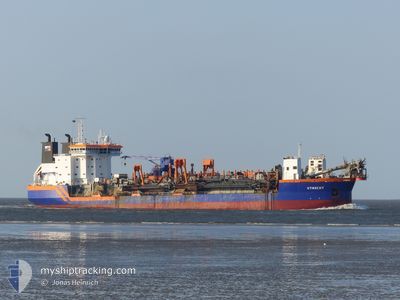
UTRECHT
Trailing Suction Hopper Dredger

Current Trip
BR RIO
| Time Travelled | 5 days |
|---|---|
| Remaining Time | --- |
| Distance Travelled | 804.76 nm |
| Remaining Distance | --- |
| AVG Speed | 10.3 Knopen |
| MAX Speed | 13.7 Knopen |
| AVG Wind | 8 knots |
| MAX Wind | 19.3 knots |
| MIN Temp | 22.3°C / 72.14°F |
| MAX Temp | 28.5°C / 83.3°F |
| Diepgang | 7.3 M |
| Positie ontvangen | 1 d geleden |
Current Position
| Lengtegraad | --- |
|---|---|
| Breedtegraat | --- |
| Status | Under way using engine |
| Snelheid | 2.2 Knopen |
| Koers | 307° |
| Gebied | South Atlantic Ocean |
| Station | T-AIS |
| Positie ontvangen | 1 d geleden |
Information
The current position of UTRECHT is in South Atlantic Ocean with coordinates -21.90245° / -40.82557° as reported on 2025-03-24 20:48 by AIS to our vessel tracker app. The vessel's current speed is 2.2 Knopen
The vessel UTRECHT (IMO: 9125956, MMSI: 245601000) is a Trailing Suction Hopper Dredger that was built in 1996 ( 29 Jaar oud ). It's sailing under the flag of [NL] Netherlands.
In this page you can find informations about the vessels current position, last detected port calls, and current voyage information. If the vessels is not in coverage by AIS you will find the latest position.
The current position of UTRECHT is detected by our AIS receivers and we are not responsible for the reliability of the data. The last position was recorded while the vessel was in Coverage by the Ais receivers of our vessel tracking app.
The current draught of UTRECHT as reported by AIS is 7.3 meters
Weather
| Temperature | 23.3°C / 73.94°F |
|---|---|
| Wind Speed | 7 knots |
| Direction | 234° SW |
| Pressure | 1013.4 hPa |
| Humidity | 91.8 % |
| Cloud Coverage | --- |


Featured Company
Last Port Calls
| Port | Arrival | Departure | Time In Port |
|---|---|---|---|
| 2025-03-20 15:06 | 2025-03-20 15:29 | 22 m | |
| 2025-03-20 12:53 | 2025-03-20 13:14 | 20 m | |
| 2025-03-20 11:54 | 2025-03-20 12:21 | 26 m | |
| 2025-03-20 09:49 | 2025-03-20 10:10 | 20 m | |
| 2025-03-20 08:09 | 2025-03-20 09:03 | 53 m | |
| 2025-03-12 12:30 | 2025-03-12 18:25 | 5 h | |
| 2025-03-12 08:46 | 2025-03-12 11:03 | 2 h | |
| 2025-03-12 04:17 | 2025-03-12 07:25 | 3 h | |
| 2025-03-12 01:51 | 2025-03-12 02:42 | 50 m | |
| 2025-03-11 22:05 | 2025-03-11 22:52 | 47 m |
Most Visited Ports (Last year)
| Port | Arrivals | |
|---|---|---|
| 356 | ||
| 35 | ||
| 23 | ||
| 6 | ||
| 5 | ||
| 1 |
Last Trips
| Origin | Departure | Destination | Arrival | Distance | |
|---|---|---|---|---|---|
| 2025-03-20 13:14 | 2025-03-20 15:06 | 7.14 nm | |||
| 2025-03-20 12:21 | 2025-03-20 12:53 | 3.88 nm | |||
| 2025-03-20 10:10 | 2025-03-20 11:54 | 8.15 nm | |||
| 2025-03-20 09:03 | 2025-03-20 09:49 | 4.11 nm | |||
| 2025-03-12 18:25 | 2025-03-20 08:09 | 415.91 nm | |||
| 2025-03-12 11:03 | 2025-03-12 12:30 | 13.26 nm | |||
| 2025-03-12 07:25 | 2025-03-12 08:46 | 13.19 nm | |||
| 2025-03-12 02:42 | 2025-03-12 04:17 | 14.95 nm | |||
| 2025-03-11 22:52 | 2025-03-12 01:51 | 10.12 nm | |||
| 2025-03-11 20:33 | 2025-03-11 22:05 | 15.75 nm |
Events
| Tijd | Evenement | Details | Positie / Bestemming | Info |
|---|---|---|---|---|
| 2025-03-25 15:09 | Start beweging | 10.26 nm, East of PORTO DO ACU |
-21.89908 / -40.83435
BR RIO
|
Snelheid: 11.6 kn Koers: 303° |
| 2025-03-25 14:59 | Stop beweging | 10.76 nm, East of PORTO DO ACU |
-21.90473 / -40.82677
BR RIO
|
Snelheid: 0.3 kn Koers: 49° |
| 2025-03-25 11:12 | Start beweging | 2 nm, North East of PORTO DO ACU |
-21.83342 / -40.98277
BR RIO
|
Snelheid: 3.1 kn Koers: 46° |
| 2025-03-25 10:52 | Stop beweging | 1.48 nm, North East of PORTO DO ACU |
-21.84180 / -40.98803
BR RIO
|
Snelheid: 0.3 kn Koers: 255° |
| 2025-03-25 09:17 | Start beweging | 10.88 nm, East of PORTO DO ACU |
-21.89938 / -40.82298
BR RIO
|
Snelheid: 11.5 kn Koers: 302° |
| 2025-03-25 09:10 | Stop beweging | 11.29 nm, East of PORTO DO ACU |
-21.90288 / -40.81633
BR RIO
|
Snelheid: 0.1 kn Koers: 301° |
| 2025-03-25 02:10 | Start beweging | 2.63 nm, North East of PORTO DO ACU |
-21.82662 / -40.97408
BR RIO
|
Snelheid: 6.8 kn Koers: 72° |
| 2025-03-25 01:21 | Stop beweging | 2.06 nm, North East of PORTO DO ACU |
-21.83215 / -40.98240
BR RIO
|
Snelheid: 0.2 kn Koers: 226° |
| 2025-03-24 20:53 | Status Changed | Default Under way using engine |
-21.89835 / -40.83580
BR RIO
|
Snelheid: 2.2 kn Koers: 307° |
| 2025-03-24 20:48 | Buitenbereik |
-21.90245 / -40.82557
South Atlantic Ocean
|
Snelheid: 2.2 kn Koers: 314° |