
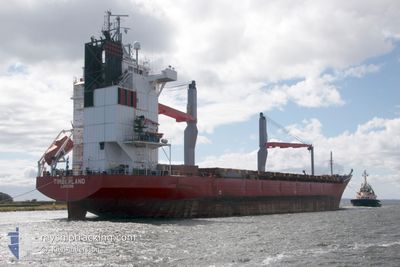
TIMBERLAND
General Cargo
Current Trip
| Trip Time | 4 days |
|---|---|
| Trip Distance | 1380.14 nm |
| AVG Speed | 13 Knopen |
| MAX Speed | 14.8 Knopen |
| Diepgang | 6.2 M |
| AVG Wind | 12.2 knots |
| MAX Wind | 20.8 knots |
| MIN Temp | 1.1°C / 33.98°F |
| MAX Temp | 14.8°C / 58.64°F |
| Positie ontvangen | 7 d geleden |
Current Position
| Lengtegraad | 21.80399° |
|---|---|
| Breedtegraat | 63.69438° |
| Status | Under way using engine |
| Snelheid | 14.1 Knopen |
| Koers | 72.6° |
| Gebied | Gulf of Bothnia |
| Station | T-AIS |
| Positie ontvangen | 7 d geleden |
Info
Information
The current position of TIMBERLAND is in Gulf of Bothnia with coordinates 63.69438° / 21.80399° as reported on 2024-05-01 00:33 by AIS to our vessel tracker app. The vessel's current speed is 14.1 Knopen and is currently inside the port of PIETARSAARI.
The vessel TIMBERLAND (IMO: 9204790, MMSI: 235090537) is a General Cargo that was built in 2000 ( 24 Jaar oud ). It's sailing under the flag of [GB] United Kingdom.
In this page you can find informations about the vessels current position, last detected port calls, and current voyage information. If the vessels is not in coverage by AIS you will find the latest position.
The current position of TIMBERLAND is detected by our AIS receivers and we are not responsible for the reliability of the data. The last position was recorded while the vessel was in Coverage by the Ais receivers of our vessel tracking app.
The current draught of TIMBERLAND as reported by AIS is 6.2 meters
Weather
| Temperature | -0.8°C / 30.56°F |
|---|---|
| Wind Speed | 9 knots |
| Direction | 69° ENE |
| Pressure | 1029 hPa |
| Humidity | 65.3 % |
| Cloud Coverage | --- |
Featured Company
Last Port Calls
| Port | Arrival | Departure | Time In Port |
|---|---|---|---|
| 2024-05-01 02:36 | |||
| 2024-04-22 04:15 | 2024-04-26 17:41 | 4 d | |
| 2024-04-01 13:38 | 2024-04-04 09:24 | 2 d | |
| 2024-03-08 15:36 | 2024-03-21 04:41 | 12 d |
Most Visited Ports (Last year)
| Port | Arrivals | |
|---|---|---|
| 5 | ||
| 3 | ||
| 3 | ||
| 2 | ||
| 2 | ||
| 2 |
Last Trips
| Origin | Departure | Destination | Arrival | Distance | |
|---|---|---|---|---|---|
| 2024-04-26 18:41 | 2024-05-01 05:36 | 1380.14 nm | |||
| 2024-04-04 12:24 | 2024-04-22 05:15 | 3915.05 nm | |||
| 2024-03-21 06:41 | 2024-04-01 16:38 | 1231.24 nm | |||
| 2024-02-21 19:19 | 2024-03-08 17:36 | 4691.16 nm |
Events
| Tijd | Evenement | Details | Positie / Bestemming | Info |
|---|---|---|---|---|
| 2024-05-01 02:51 | Stop beweging |
63.71633 / 22.69071
[FI] PIETARSAARI
|
Snelheid: Koers: 357° |
|
| 2024-05-01 02:36 | Aankomsthaven |
|
63.71876 / 22.68626
[FI] PIETARSAARI
|
Snelheid: 5 kn Koers: 109° |
| 2024-05-01 00:40 | Status Changed | Default Under way using engine |
63.70158 / 21.86905
FI PRS
|
Snelheid: 14.1 kn Koers: 72.6° |
| 2024-05-01 00:33 | Buitenbereik |
63.69438 / 21.80399
Gulf of Bothnia
FI PRS
|
Snelheid: 14.1 kn Koers: 72.6° |
|
| 2024-05-01 00:28 | Status Changed | Under way using engine Default |
63.68890 / 21.76299
FI PRS
|
Snelheid: 14 kn Koers: 67° |
| 2024-05-01 00:21 | Status Changed | Default Under way using engine |
63.67928 / 21.70296
FI PRS
|
Snelheid: 14.1 kn Koers: 85.4° |
| 2024-05-01 00:10 | Status Changed | Under way using engine Default |
63.67179 / 21.60946
FI PRS
|
Snelheid: 14 kn Koers: 82° |
| 2024-04-30 23:56 | Status Changed | Default Under way using engine |
63.65915 / 21.49706
FI PRS
|
Snelheid: 14 kn Koers: 67.5° |
| 2024-04-30 23:52 | Wijzig zee gebeid | Finnish part of the Gulf of Bothnia Swedish part of the Gulf of Bothnia |
63.65218 / 21.45904
Gulf of Bothnia
FI PRS
|
Snelheid: 14 kn Koers: 67.5° |
| 2024-04-30 23:51 | Status Changed | Under way using engine Default |
63.65071 / 21.45097
FI PRS
|
Snelheid: 13.9 kn Koers: 68° |