
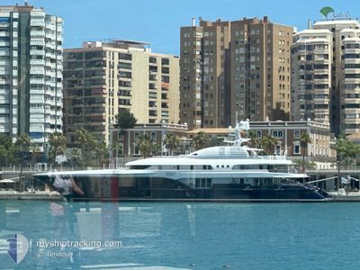
SYCARA V
Yacht
Current Trip
BLSBH
| Time Travelled | 1 day |
|---|---|
| Remaining Time | --- |
| Distance Travelled | 13.98 nm |
| Remaining Distance | --- |
| AVG Speed | 11 Knopen |
| MAX Speed | 13.1 Knopen |
| AVG Wind | 14.5 knots |
| MAX Wind | 17 knots |
| MIN Temp | 25.5°C / 77.9°F |
| MAX Temp | 26.2°C / 79.16°F |
| Diepgang | 3.7 M |
| Positie ontvangen | 9 m geleden |
Current Position
| Lengtegraad | --- |
|---|---|
| Breedtegraat | --- |
| Status | At anchor |
| Snelheid | 0.2 Knopen |
| Koers | 150° |
| Gebied | Caribbean Sea |
| Station | T-AIS |
| Positie ontvangen | 9 m geleden |
Info
Information
The current position of SYCARA V is in Caribbean Sea with coordinates 17.89347° / -62.85381° as reported on 2025-03-04 13:37 by AIS to our vessel tracker app. The vessel's current speed is 0.2 Knopen
The vessel SYCARA V (IMO: 1009766, MMSI: 319035600) is a Yacht that was built in 2010 ( 15 Jaar oud ). It's sailing under the flag of [KY] Cayman Is.
In this page you can find informations about the vessels current position, last detected port calls, and current voyage information. If the vessels is not in coverage by AIS you will find the latest position.
The current position of SYCARA V is detected by our AIS receivers and we are not responsible for the reliability of the data. The last position was recorded while the vessel was in Coverage by the Ais receivers of our vessel tracking app.
The current draught of SYCARA V as reported by AIS is 3.7 meters
Weather
| Temperature | 25.8°C / 78.44°F |
|---|---|
| Wind Speed | 15 knots |
| Direction | 108° ESE |
| Pressure | 1016.1 hPa |
| Humidity | 74.8 % |
| Cloud Coverage | 11 % |
Featured Company
Last Port Calls
| Port | Arrival | Departure | Time In Port |
|---|---|---|---|
| 2025-02-23 15:34 | 2025-03-02 17:44 | 7 d | |
| 2025-02-22 07:52 | 2025-02-23 06:50 | 22 h | |
| 2025-02-12 07:57 | 2025-02-16 08:53 | 4 d | |
| 2025-02-01 15:49 | 2025-02-11 17:10 | 10 d | |
| 2025-01-24 17:36 | 2025-02-01 14:00 | 7 d |
Most Visited Ports (Last year)
| Port | Arrivals | |
|---|---|---|
| 5 | ||
| 3 | ||
| 2 | ||
| 2 | ||
| 2 | ||
| 1 |
Last Trips
| Origin | Departure | Destination | Arrival | Distance | |
|---|---|---|---|---|---|
| 2025-02-23 06:50 | 2025-02-23 15:34 | 109.26 nm | |||
| 2025-02-16 08:53 | 2025-02-22 07:52 | 110.78 nm | |||
| 2025-02-11 17:10 | 2025-02-12 07:57 | 110.85 nm | |||
| 2025-02-01 14:00 | 2025-02-01 15:49 | 13.77 nm | |||
| 2024-12-27 11:06 | 2025-01-24 17:36 | 47.95 nm |
Events
| Tijd | Evenement | Details | Positie / Bestemming | Info |
|---|---|---|---|---|
| 2025-03-04 11:04 | Binnenbereik |
17.89352 / -62.85381
Caribbean Sea
|
Snelheid: 0.1 kn Koers: 157° |
|
| 2025-03-04 09:55 | Buitenbereik |
17.89330 / -62.85387
Caribbean Sea
|
Snelheid: Koers: 165.3° |
|
| 2025-03-04 08:16 | Binnenbereik |
17.89347 / -62.85383
Caribbean Sea
|
Snelheid: 0.2 kn Koers: 200.4° |
|
| 2025-03-04 06:04 | Buitenbereik |
17.89335 / -62.85388
Caribbean Sea
|
Snelheid: 0.1 kn Koers: 207° |
|
| 2025-03-04 05:19 | Binnenbereik |
17.89332 / -62.85387
Caribbean Sea
|
Snelheid: Koers: 187.1° |
|
| 2025-03-04 03:10 | Buitenbereik |
17.89335 / -62.85387
Caribbean Sea
|
Snelheid: Koers: 297.2° |
|
| 2025-03-03 16:13 | Binnenbereik |
17.89357 / -62.85378
Caribbean Sea
|
Snelheid: 0.2 kn Koers: 190.1° |
|
| 2025-03-03 14:01 | Buitenbereik |
17.89345 / -62.85381
Caribbean Sea
|
Snelheid: 0.1 kn Koers: 254.5° |
|
| 2025-03-03 12:37 | Binnenbereik |
17.89337 / -62.85388
Caribbean Sea
|
Snelheid: Koers: 68.6° |
|
| 2025-03-03 11:28 | Buitenbereik |
17.89332 / -62.85385
Caribbean Sea
|
Snelheid: 0.1 kn Koers: 66.4° |