
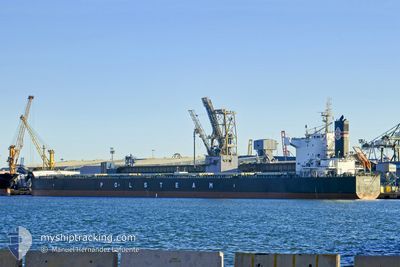
SUDETY
Bulk Carrier
Current Trip
| Time Travelled | 2 days |
|---|---|
| Remaining Time | --- |
| Distance Travelled | 672.09 nm |
| Remaining Distance | --- |
| AVG Speed | 12.9 Knopen |
| MAX Speed | 14 Knopen |
| AVG Wind | 7.7 knots |
| MAX Wind | 15.5 knots |
| MIN Temp | 15.5°C / 59.9°F |
| MAX Temp | 19°C / 66.2°F |
| Diepgang | 7.3 M |
| Positie ontvangen | 1 m geleden |
Current Position
| Lengtegraad | 15.22938° |
|---|---|
| Breedtegraat | 36.44059° |
| Status | Under way using engine |
| Snelheid | 12.2 Knopen |
| Koers | 265.1° |
| Gebied | Mediterranean Sea - Eastern Basin |
| Station | T-AIS |
| Positie ontvangen | 1 m geleden |
Info
Information
The current position of SUDETY is in Mediterranean Sea - Eastern Basin with coordinates 36.44059° / 15.22938° as reported on 2024-05-01 23:56 by AIS to our vessel tracker app. The vessel's current speed is 12.2 Knopen
The vessel SUDETY (IMO: 9582518, MMSI: 636015816) is a Bulk Carrier that was built in 2013 ( 11 Jaar oud ). It's sailing under the flag of [LR] Liberia.
In this page you can find informations about the vessels current position, last detected port calls, and current voyage information. If the vessels is not in coverage by AIS you will find the latest position.
The current position of SUDETY is detected by our AIS receivers and we are not responsible for the reliability of the data. The last position was recorded while the vessel was in Coverage by the Ais receivers of our vessel tracking app.
The current draught of SUDETY as reported by AIS is 7.3 meters
Weather
| Temperature | 16.8°C / 62.24°F |
|---|---|
| Wind Speed | 13 knots |
| Direction | 288° WNW |
| Pressure | 1013.6 hPa |
| Humidity | 86.2 % |
| Cloud Coverage | 3 % |
Featured Company
Events
| Tijd | Evenement | Details | Positie / Bestemming | Info |
|---|---|---|---|---|
| 2024-05-01 23:43 | Status Changed | Under way using engine Default |
36.44448 / 15.28060
BR ITA
|
Snelheid: 11.8 kn Koers: 265° |
| 2024-05-01 23:18 | Status Changed | Default Under way using engine |
36.45167 / 15.38333
BR ITA
|
Snelheid: 12.4 kn Koers: 233.9° |
| 2024-05-01 23:01 | Status Changed | Under way using engine Default |
36.49766 / 15.43238
BR ITA
|
Snelheid: 13.2 kn Koers: 219° |
| 2024-05-01 22:51 | Status Changed | Default Under way using engine |
36.52642 / 15.46067
BR ITA
|
Snelheid: 13.2 kn Koers: 218.8° |
| 2024-05-01 22:17 | Gevonden in zee | Italian part of the Mediterranean Sea - Eastern Basin |
36.62810 / 15.55347
Mediterranean Sea - Eastern Basin
BR ITA
|
Snelheid: 12.8 kn Koers: 215.2° |
| 2024-05-01 20:25 | Status Changed | Under way using engine Default |
36.94521 / 15.84077
BR ITA
|
Snelheid: 12 kn Koers: 218° |
| 2024-05-01 20:21 | Status Changed | Default Under way using engine |
36.95500 / 15.85167
BR ITA
|
Snelheid: 12.1 kn Koers: 218.1° |
| 2024-05-01 19:55 | Status Changed | Under way using engine Default |
37.02632 / 15.91929
BR ITA
|
Snelheid: 11.9 kn Koers: 217° |
| 2024-05-01 19:50 | Status Changed | Default Under way using engine |
37.04003 / 15.93227
BR ITA
|
Snelheid: 11.9 kn Koers: 216.9° |
| 2024-05-01 19:46 | Status Changed | Under way using engine Default |
37.05080 / 15.94243
BR ITA
|
Snelheid: 11 kn Koers: 216° |