

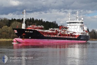
STOLT AUK
Chemical Tanker

Current Trip
| Time Travelled | 1 day |
|---|---|
| Remaining Time | 1 h, 49 mins |
| Distance Travelled | 331.80 nm |
| Remaining Distance | 17.59 nm |
| AVG Speed | 11.8 Knopen |
| MAX Speed | 15.1 Knopen |
| AVG Wind | 7.7 knots |
| MAX Wind | 21.7 knots |
| MIN Temp | 4.7°C / 40.46°F |
| MAX Temp | 7.6°C / 45.68°F |
| Diepgang | 6.3 M |
| Positie ontvangen | Nu |
Current Position
| Lengtegraad | --- |
|---|---|
| Breedtegraat | --- |
| Status | Under way using engine |
| Snelheid | 8.5 Knopen |
| Koers | 217.5° |
| Gebied | North Sea |
| Station | T-AIS |
| Positie ontvangen | Nu |
Information
The current position of STOLT AUK is in North Sea with coordinates 53.55912° / 0.25537° as reported on 2025-02-28 13:27 by AIS to our vessel tracker app. The vessel's current speed is 8.5 Knopen and is heading at the port of IMMINGHAM. The estimated time of arrival as calculated by MyShipTracking vessel tracking app is 2025-02-28 15:17 LT
The vessel STOLT AUK (IMO: 9164108, MMSI: 235104739) is a Chemical Tanker that was built in 2001 ( 24 Jaar oud ). It's sailing under the flag of [GB] United Kingdom.
In this page you can find informations about the vessels current position, last detected port calls, and current voyage information. If the vessels is not in coverage by AIS you will find the latest position.
The current position of STOLT AUK is detected by our AIS receivers and we are not responsible for the reliability of the data. The last position was recorded while the vessel was in Coverage by the Ais receivers of our vessel tracking app.
The current draught of STOLT AUK as reported by AIS is 6.3 meters
Weather
| Temperature | 5.8°C / 42.44°F |
|---|---|
| Wind Speed | 2 knots |
| Direction | 44° NE |
| Pressure | 1029.3 hPa |
| Humidity | 71.2 % |
| Cloud Coverage | --- |


Featured Company
Last Port Calls
| Port | Arrival | Departure | Time In Port |
|---|---|---|---|
| 2025-02-27 10:24 | 2025-02-27 11:29 | 1 h | |
| 2025-02-26 15:40 | 2025-02-27 10:15 | 18 h | |
| 2025-02-25 08:13 | 2025-02-25 17:12 | 8 h | |
| 2025-02-23 10:35 | 2025-02-24 11:59 | 1 d | |
| 2025-02-19 20:11 | 2025-02-20 16:31 | 20 h | |
| 2025-02-17 18:37 | 2025-02-19 03:23 | 1 d | |
| 2025-02-12 21:21 | 2025-02-14 23:41 | 2 d | |
| 2025-02-10 01:07 | 2025-02-10 17:43 | 16 h | |
| 2025-02-05 22:35 | 2025-02-07 00:23 | 1 d | |
| 2025-01-31 10:05 | 2025-01-31 10:42 | 37 m |
Last Trips
| Origin | Departure | Destination | Arrival | Distance | |
|---|---|---|---|---|---|
| 2025-02-27 10:15 | 2025-02-27 10:24 | 0.80 nm | |||
| 2025-02-25 17:12 | 2025-02-26 15:40 | 270.10 nm | |||
| 2025-02-24 11:59 | 2025-02-25 08:13 | 204.94 nm | |||
| 2025-02-20 16:31 | 2025-02-23 10:35 | 257.41 nm | |||
| 2025-02-19 03:23 | 2025-02-19 20:11 | 191.66 nm | |||
| 2025-02-14 23:41 | 2025-02-17 18:37 | 121.05 nm | |||
| 2025-02-10 17:43 | 2025-02-12 21:21 | 411.30 nm | |||
| 2025-02-07 00:23 | 2025-02-10 01:07 | 399.09 nm | |||
| 2025-01-31 10:42 | 2025-02-05 22:35 | 739.74 nm | |||
| 2025-01-31 09:45 | 2025-01-31 10:05 | 2.00 nm |
Events
| Tijd | Evenement | Details | Positie / Bestemming | Info |
|---|---|---|---|---|
| 2025-02-28 12:56 | Status Changed | Under way using engine Default |
53.62265 / .34295
DEBRB>GBIMM
|
Snelheid: 9.1 kn Koers: 207° |
| 2025-02-28 12:53 | Status Changed | Default Under way using engine |
53.62871 / .34809
DEBRB>GBIMM
|
Snelheid: 9.8 kn Koers: 211.5° |
| 2025-02-28 12:45 | Status Changed | Under way using engine Default |
53.64724 / .36565
DEBRB>GBIMM
|
Snelheid: 9.8 kn Koers: 241° |
| 2025-02-28 12:29 | Binnenbereik |
53.64515 / .36284
North Sea
DEBRB>GBIMM
|
Snelheid: 9.6 kn Koers: 218.7° |
|
| 2025-02-28 11:20 | Status Changed | Default Under way using engine |
53.75722 / .69690
DEBRB>GBIMM
|
Snelheid: 9.4 kn Koers: 240.4° |
| 2025-02-28 11:18 | Status Changed | Under way using engine Default |
53.76004 / .70529
DEBRB>GBIMM
|
Snelheid: 9.4 kn Koers: 241° |
| 2025-02-28 11:18 | Buitenbereik |
53.76004 / .70529
North Sea
DEBRB>GBIMM
|
Snelheid: 9.4 kn Koers: 240.4° |
|
| 2025-02-28 11:05 | Status Changed | Default Under way using engine |
53.77570 / .75374
DEBRB>GBIMM
|
Snelheid: 9.4 kn Koers: 240.8° |
| 2025-02-28 10:57 | Status Changed | Under way using engine Default |
53.78632 / .78620
DEBRB>GBIMM
|
Snelheid: 9.5 kn Koers: 242° |
| 2025-02-28 10:38 | Status Changed | Default Under way using engine |
53.81127 / .86053
DEBRB>GBIMM
|
Snelheid: 9.4 kn Koers: 240.6° |