
STAMFORD
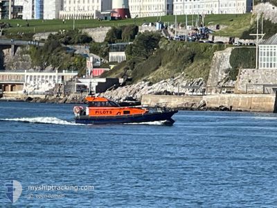
Pilot Vessel
Current Trip
| Trip Time | 25 days |
|---|---|
| Trip Distance | 1.59 nm |
| AVG Speed | 7.3 Knopen |
| MAX Speed | 7.3 Knopen |
| Diepgang | --- |
| AVG Wind | 24.6 knots |
| MAX Wind | 33.5 knots |
| MIN Temp | 10.4°C / 50.72°F |
| MAX Temp | 13.3°C / 55.94°F |
| Positie ontvangen | 10 h, 53 m geleden |
Current Position
| Lengtegraad | --- |
|---|---|
| Breedtegraat | --- |
| Status | Default |
| Snelheid | 0.3 Knopen |
| Koers | --- |
| Gebied | English Channel |
| Station | T-AIS |
| Positie ontvangen | 10 h, 53 m geleden |
Info
Information
The current position of STAMFORD is in English Channel with coordinates 50.36571° / -4.13342° as reported on 2025-12-05 16:13 by AIS to our vessel tracker app. The vessel's current speed is 0.3 Knopen and is currently inside the port of PLYMOUTH.
The vessel STAMFORD (MMSI: 232031807) is a Pilot Vessel It's sailing under the flag of [GB] United Kingdom.
In this page you can find informations about the vessels current position, last detected port calls, and current voyage information. If the vessels is not in coverage by AIS you will find the latest position.
The current position of STAMFORD is detected by our AIS receivers and we are not responsible for the reliability of the data. The last position was recorded while the vessel was in Coverage by the Ais receivers of our vessel tracking app.
Weather
| Temperature | 13.6°C / 56.48°F |
|---|---|
| Wind Speed | 26 knots |
| Direction | 237° WSW |
| Pressure | 991.8 hPa |
| Humidity | 81.5 % |
| Cloud Coverage | 100 % |
Featured Company
Last Port Calls
| Port | Arrival | Departure | Time In Port |
|---|---|---|---|
| 2025-12-05 16:03 | |||
| 2025-11-10 08:38 | 2025-11-10 09:33 | 54 m | |
| 2025-11-07 15:45 | 2025-11-10 07:53 | 2 d | |
| 2025-11-07 06:37 | 2025-11-07 14:39 | 8 h | |
| 2025-11-07 05:27 | 2025-11-07 05:48 | 21 m | |
| 2025-11-06 12:02 | 2025-11-07 04:17 | 16 h | |
| 2025-11-06 11:06 | 2025-11-06 11:12 | 6 m | |
| 2025-11-06 08:34 | 2025-11-06 08:39 | 5 m | |
| 2025-11-06 07:23 | 2025-11-06 07:31 | 7 m | |
| 2025-11-06 05:58 | 2025-11-06 06:59 | 1 h |
Last Trips
| Origin | Departure | Destination | Arrival | Distance | |
|---|---|---|---|---|---|
| 2025-11-10 09:33 | 2025-12-05 16:03 | 1.59 nm | |||
| 2025-11-10 07:53 | 2025-11-10 08:38 | 5.46 nm | |||
| 2025-11-07 14:39 | 2025-11-07 15:45 | 5.74 nm | |||
| 2025-11-07 05:48 | 2025-11-07 06:37 | 6.19 nm | |||
| 2025-11-07 04:17 | 2025-11-07 05:27 | 10.73 nm | |||
| 2025-11-06 11:12 | 2025-11-06 12:02 | 9.04 nm | |||
| 2025-11-06 08:39 | 2025-11-06 11:06 | 7.72 nm | |||
| 2025-11-06 07:31 | 2025-11-06 08:34 | 12.03 nm | |||
| 2025-11-06 06:59 | 2025-11-06 07:23 | 3.79 nm | |||
| 2025-11-06 03:26 | 2025-11-06 05:58 | 15.60 nm |
Events
| Tijd | Evenement | Details | Positie / Bestemming | Info |
|---|---|---|---|---|
| 2025-12-05 16:13 | Buitenbereik |
50.36571 / -4.13342
English Channel
[GB] PLYMOUTH
|
Snelheid: 0.3 kn Koers: 49.4° |
|
| 2025-12-05 16:04 | Stop beweging |
50.36568 / -4.13348
[GB] PLYMOUTH
|
Snelheid: 0.2 kn Koers: 511° |
|
| 2025-12-05 16:03 | Aankomsthaven |
|
50.36568 / -4.13348
[GB] PLYMOUTH
|
Snelheid: 2.4 kn Koers: 511° |
| 2025-12-05 15:48 | Start beweging | 1.27 nm, East of PLYMOUTH |
50.35949 / -4.12143
|
Snelheid: 5.5 kn Koers: 80.1° |
| 2025-12-05 14:17 | Stop beweging | 1.19 nm, East of PLYMOUTH |
50.35800 / -4.12420
|
Snelheid: 0.3 kn Koers: 511° |
| 2025-12-05 14:15 | Binnenbereik |
50.35808 / -4.12434
English Channel
|
Snelheid: 1.5 kn Koers: 125.5° |