

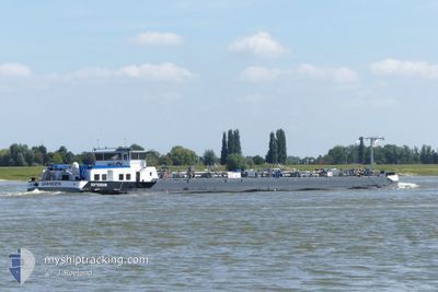
SPANGEN
Tanker

Current Trip
INFRACOR / EVONIK MA
| Time Travelled | 1 day |
|---|---|
| Remaining Time | --- |
| Distance Travelled | 23.39 nm |
| Remaining Distance | --- |
| AVG Speed | 5.2 Knopen |
| MAX Speed | 5.8 Knopen |
| AVG Wind | 10.4 knots |
| MAX Wind | 11.5 knots |
| MIN Temp | -2.1°C / 28.22°F |
| MAX Temp | 1.5°C / 34.7°F |
| Diepgang | 0.3 M |
| Positie ontvangen | 23 h, 44 m geleden |
Current Position
| Lengtegraad | --- |
|---|---|
| Breedtegraat | --- |
| Status | Under way using engine |
| Snelheid | 5.4 Knopen |
| Koers | 78.1° |
| Gebied | North Sea |
| Station | T-AIS |
| Positie ontvangen | 23 h, 44 m geleden |
Information
The current position of SPANGEN is in North Sea with coordinates 51.65843° / 6.56181° as reported on 2025-02-19 09:02 by AIS to our vessel tracker app. The vessel's current speed is 5.4 Knopen
The vessel SPANGEN (MMSI: 244750249) is a Tanker It's sailing under the flag of [NL] Netherlands.
In this page you can find informations about the vessels current position, last detected port calls, and current voyage information. If the vessels is not in coverage by AIS you will find the latest position.
The current position of SPANGEN is detected by our AIS receivers and we are not responsible for the reliability of the data. The last position was recorded while the vessel was in Coverage by the Ais receivers of our vessel tracking app.
The current draught of SPANGEN as reported by AIS is 0.3 meters
Weather
| Temperature | 1.2°C / 34.16°F |
|---|---|
| Wind Speed | 11 knots |
| Direction | 126° SE |
| Pressure | 1023.8 hPa |
| Humidity | 36.5 % |
| Cloud Coverage | 100 % |


Featured Company
Last Port Calls
| Port | Arrival | Departure | Time In Port |
|---|---|---|---|
| 2025-02-18 16:00 | 2025-02-19 05:32 | 13 h | |
| 2025-02-17 11:40 | 2025-02-18 04:19 | 16 h | |
| 2025-02-13 16:40 | 2025-02-14 06:21 | 13 h | |
| 2025-02-12 19:11 | 2025-02-13 09:07 | 13 h | |
| 2025-02-12 18:12 | 2025-02-12 19:07 | 54 m | |
| 2025-02-09 16:42 | 2025-02-10 06:19 | 13 h | |
| 2025-02-09 14:31 | 2025-02-09 14:44 | 12 m | |
| 2025-02-08 18:46 | 2025-02-09 09:03 | 14 h | |
| 2025-02-06 17:39 | 2025-02-06 17:45 | 6 m | |
| 2025-02-05 16:21 | 2025-02-06 06:13 | 13 h |
Last Trips
| Origin | Departure | Destination | Arrival | Distance | |
|---|---|---|---|---|---|
| 2025-02-18 04:19 | 2025-02-18 16:00 | 75.99 nm | |||
| 2025-02-14 06:21 | 2025-02-17 11:40 | 201.72 nm | |||
| 2025-02-13 09:07 | 2025-02-13 16:40 | 76.08 nm | |||
| 2025-02-12 19:07 | 2025-02-12 19:11 | 0.33 nm | |||
| 2025-02-10 06:19 | 2025-02-12 18:12 | 121.75 nm | |||
| 2025-02-09 14:44 | 2025-02-09 16:42 | 16.14 nm | |||
| 2025-02-09 09:03 | 2025-02-09 14:31 | 59.24 nm | |||
| 2025-02-06 17:45 | 2025-02-08 18:46 | 44.04 nm | |||
| 2025-02-06 06:13 | 2025-02-06 17:39 | 75.87 nm | |||
| 2025-02-05 05:47 | 2025-02-05 16:21 | 97.60 nm |
Events
| Tijd | Evenement | Details | Positie / Bestemming | Info |
|---|---|---|---|---|
| 2025-02-19 09:08 | Status Changed | Default Under way using engine |
51.65929 / 6.57562
INFRACOR / EVONIK MA
|
Snelheid: 5.4 kn Koers: 78.1° |
| 2025-02-19 09:02 | Buitenbereik |
51.65843 / 6.56181
North Sea
|
Snelheid: 5.4 kn Koers: 78.1° |
|
| 2025-02-19 08:52 | Status Changed | Under way using engine Default |
51.65852 / 6.53888
INFRACOR / EVONIK MA
|
Snelheid: 5.4 kn Koers: 90° |
| 2025-02-19 08:44 | Binnenbereik |
51.65852 / 6.53888
North Sea
|
Snelheid: 5.4 kn Koers: 109.2° |
|
| 2025-02-19 06:15 | Buitenbereik |
51.79980 / 6.30956
North Sea
|
Snelheid: 5.6 kn Koers: 143.7° |
|
| 2025-02-19 04:32 | Vertrekhaven |
|
51.85399 / 6.08866
INFRACOR / EVONIK MA
|
Snelheid: 3.4 kn Koers: 190.7° |
| 2025-02-19 04:32 | Start beweging |
51.85453 / 6.08856
[NL] LOBITH
|
Snelheid: 4.7 kn Koers: 202.6° |
|
| 2025-02-18 15:05 | Stop beweging |
51.85545 / 6.09129
[NL] LOBITH
|
Snelheid: 0.3 kn Koers: 511° |
|
| 2025-02-18 15:00 | Aankomsthaven |
|
51.85537 / 6.08964
[NL] LOBITH
|
Snelheid: 1.8 kn Koers: 511° |
| 2025-02-18 03:19 | Vertrekhaven |
|
51.89908 / 4.35778
INFRACOR / EVONIK MA
|
Snelheid: 5.6 kn Koers: 111.1° |