
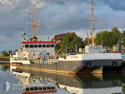
SEEKRABBE
Dredging or underwater ops
Current Trip
HARLESIEL
| Time Travelled | 1 h, 1 mins |
|---|---|
| Remaining Time | --- |
| Distance Travelled | 2.18 nm |
| Remaining Distance | --- |
| AVG Speed | --- |
| MAX Speed | --- |
| AVG Wind | 13.9 knots |
| MAX Wind | 16 knots |
| MIN Temp | 13.6°C / 56.48°F |
| MAX Temp | 14.1°C / 57.38°F |
| Diepgang | 1.6 M |
| Positie ontvangen | Nu |
Current Position
| Lengtegraad | 7.82626° |
|---|---|
| Breedtegraat | 53.73034° |
| Status | Restricted manoeuverability |
| Snelheid | 1.8 Knopen |
| Koers | 226° |
| Gebied | North Sea |
| Station | T-AIS |
| Positie ontvangen | Nu |
Info
Information
The current position of SEEKRABBE is in North Sea with coordinates 53.73034° / 7.82626° as reported on 2024-05-17 05:25 by AIS to our vessel tracker app. The vessel's current speed is 1.8 Knopen
The vessel SEEKRABBE (IMO: 9059066, MMSI: 211232950) is a Dredging or underwater ops It's sailing under the flag of [DE] Germany.
In this page you can find informations about the vessels current position, last detected port calls, and current voyage information. If the vessels is not in coverage by AIS you will find the latest position.
The current position of SEEKRABBE is detected by our AIS receivers and we are not responsible for the reliability of the data. The last position was recorded while the vessel was in Coverage by the Ais receivers of our vessel tracking app.
The current draught of SEEKRABBE as reported by AIS is 1.6 meters
Weather
| Temperature | 14°C / 57.2°F |
|---|---|
| Wind Speed | 16 knots |
| Direction | 92° E |
| Pressure | 1008.9 hPa |
| Humidity | 86.2 % |
| Cloud Coverage | 72 % |
Featured Company
Last Port Calls
| Port | Arrival | Departure | Time In Port |
|---|---|---|---|
| 2024-05-16 22:20 | 2024-05-17 06:25 | 8 h | |
| 2024-05-16 09:34 | 2024-05-16 16:44 | 7 h | |
| 2024-05-16 09:07 | 2024-05-16 09:17 | 10 m | |
| 2024-05-15 20:56 | 2024-05-16 07:23 | 10 h | |
| 2024-05-15 08:55 | 2024-05-15 17:38 | 8 h | |
| 2024-05-15 06:23 | 2024-05-15 08:45 | 2 h | |
| 2024-05-14 20:04 | 2024-05-15 04:43 | 8 h | |
| 2024-05-06 13:53 | 2024-05-14 15:08 | 8 d | |
| 2024-05-06 11:40 | 2024-05-06 12:21 | 41 m | |
| 2024-05-06 08:40 | 2024-05-06 09:07 | 27 m |
Most Visited Ports (Last year)
| Port | Arrivals | |
|---|---|---|
| 155 | ||
| 64 | ||
| 46 | ||
| 43 | ||
| 10 | ||
| 9 |
Last Trips
| Origin | Departure | Destination | Arrival | Distance | |
|---|---|---|---|---|---|
| 2024-05-16 16:44 | 2024-05-16 22:20 | 13.18 nm | |||
| 2024-05-16 09:17 | 2024-05-16 09:34 | 0.21 nm | |||
| 2024-05-16 07:23 | 2024-05-16 09:07 | 3.60 nm | |||
| 2024-05-15 17:38 | 2024-05-15 20:56 | 12.14 nm | |||
| 2024-05-15 08:45 | 2024-05-15 08:55 | 0.25 nm | |||
| 2024-05-15 04:43 | 2024-05-15 06:23 | 3.88 nm | |||
| 2024-05-14 15:08 | 2024-05-14 20:04 | 22.81 nm | |||
| 2024-05-06 12:21 | 2024-05-06 13:53 | 2.68 nm | |||
| 2024-05-06 09:07 | 2024-05-06 11:40 | 9.53 nm | |||
| 2024-05-06 07:32 | 2024-05-06 08:40 | 4.42 nm |
Events
| Tijd | Evenement | Details | Positie / Bestemming | Info |
|---|---|---|---|---|
| 2024-05-17 05:23 | Stop beweging | 1.74 nm, North of HARLESIEL |
53.73005 / 7.82548
HARLESIEL
|
Snelheid: Koers: 233° |
| 2024-05-17 04:25 | Vertrekhaven |
|
53.71217 / 7.81135
HARLESIEL
|
Snelheid: 2.6 kn Koers: 15° |
| 2024-05-17 04:20 | Start beweging |
53.70815 / 7.80950
[DE] HARLESIEL
|
Snelheid: 3.1 kn Koers: 13° |
|
| 2024-05-16 20:20 | Aankomsthaven |
|
53.70730 / 7.80866
[DE] HARLESIEL
|
Snelheid: 0.8 kn Koers: 16° |
| 2024-05-16 18:06 | Stop beweging | 2.26 nm, North East of HARLESIEL |
53.73633 / 7.83759
HARLESIEL
|
Snelheid: 0.1 kn Koers: 223° |
| 2024-05-16 17:54 | Status Changed | Restricted manoeuverability Default |
53.74912 / 7.85896
HARLESIEL
|
Snelheid: 7 kn Koers: 173° |
| 2024-05-16 17:51 | Status Changed | Default Restricted manoeuverability |
53.75726 / 7.86211
HARLESIEL
|
Snelheid: 7.5 kn Koers: 161.7° |
| 2024-05-16 17:36 | Start beweging | 1.17 nm, West of WANGEROOGE |
53.77836 / 7.83543
HARLESIEL
|
Snelheid: 7.6 kn Koers: 73.6° |
| 2024-05-16 17:03 | Stop beweging | 1.31 nm, West of WANGEROOGE |
53.77747 / 7.83103
HARLESIEL
|
Snelheid: 0.3 kn Koers: 98° |
| 2024-05-16 16:57 | Status Changed | Restricted manoeuverability Default |
53.77891 / 7.83502
HARLESIEL
|
Snelheid: 7.5 kn Koers: 318° |