
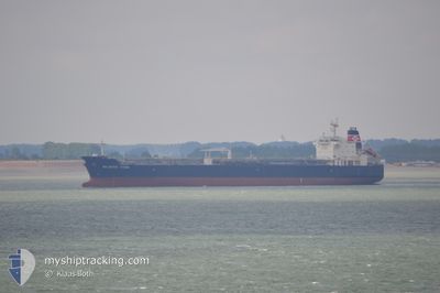
SEAWAYS TITAN
Oil/Chemical Tanker
Current Trip
BRPNG
| Time Travelled | 41 days |
|---|---|
| Remaining Time | --- |
| Distance Travelled | 9440.08 nm |
| Remaining Distance | --- |
| AVG Speed | 11.5 Knopen |
| MAX Speed | 15.3 Knopen |
| AVG Wind | 10.1 knots |
| MAX Wind | 27 knots |
| MIN Temp | 17.2°C / 62.96°F |
| MAX Temp | 30.6°C / 87.08°F |
| Diepgang | 10.1 M |
| Positie ontvangen | 28 d geleden |
Current Position
| Lengtegraad | 19.11311° |
|---|---|
| Breedtegraat | -35.14947° |
| Status | Under way using engine |
| Snelheid | 10.6 Knopen |
| Koers | 92.4° |
| Gebied | South Atlantic Ocean |
| Station | T-AIS |
| Positie ontvangen | 28 d geleden |
Info
Information
The current position of SEAWAYS TITAN is in South Atlantic Ocean with coordinates -35.14947° / 19.11311° as reported on 2024-04-16 11:37 by AIS to our vessel tracker app. The vessel's current speed is 10.6 Knopen
The vessel SEAWAYS TITAN (IMO: 9360324, MMSI: 477163800) is a Oil/Chemical Tanker that was built in 2008 ( 16 Jaar oud ). It's sailing under the flag of [HK] Hong Kong.
In this page you can find informations about the vessels current position, last detected port calls, and current voyage information. If the vessels is not in coverage by AIS you will find the latest position.
The current position of SEAWAYS TITAN is detected by our AIS receivers and we are not responsible for the reliability of the data. The last position was recorded while the vessel was in Coverage by the Ais receivers of our vessel tracking app.
The current draught of SEAWAYS TITAN as reported by AIS is 10.1 meters
Weather
| Temperature | 29°C / 84.2°F |
|---|---|
| Wind Speed | 5 knots |
| Direction | 216° SW |
| Pressure | 1011.1 hPa |
| Humidity | 80.5 % |
| Cloud Coverage | 10 % |
Featured Company
Last Port Calls
| Port | Arrival | Departure | Time In Port |
|---|---|---|---|
| 2024-04-02 12:58 | 2024-04-03 14:54 | 1 d | |
| 2024-03-24 11:30 | 2024-03-27 06:46 | 2 d |
Last Trips
| Origin | Departure | Destination | Arrival | Distance | |
|---|---|---|---|---|---|
| 2024-03-27 03:46 | 2024-04-02 09:58 | 1137.23 nm | |||
| 2024-01-26 08:29 | 2024-03-24 08:30 | 6363.38 nm |
Events
| Tijd | Evenement | Details | Positie / Bestemming | Info |
|---|---|---|---|---|
| 2024-05-14 09:29 | Stop beweging |
21.02156 / 87.87328
BRPNG
|
Snelheid: 0.3 kn Koers: 262° |
|
| 2024-05-13 09:21 | Start beweging | 5.82 nm, North West of CHITTAGONG |
22.27404 / 91.72101
BRPNG
|
Snelheid: 4.9 kn Koers: 175° |
| 2024-05-08 17:52 | Stop beweging | 5.86 nm, North West of CHITTAGONG |
22.27619 / 91.72115
BRPNG
|
Snelheid: 0.3 kn Koers: 160° |
| 2024-05-08 14:46 | Start beweging |
21.86303 / 91.78732
BRPNG
|
Snelheid: 6.8 kn Koers: 2° |
|
| 2024-05-05 12:49 | Stop beweging |
21.84667 / 91.79166
BRPNG
|
Snelheid: Koers: -1° |