
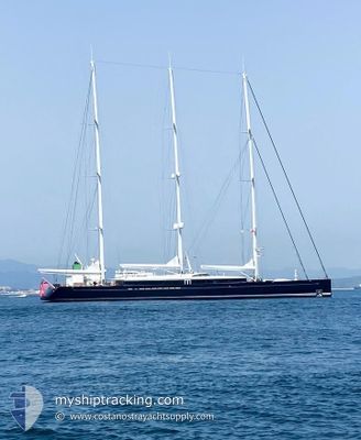
SEA EAGLE
Sailing
Current Trip
| Time Travelled | 2 days |
|---|---|
| Remaining Time | --- |
| Distance Travelled | 129.96 nm |
| Remaining Distance | --- |
| AVG Speed | 10.5 Knopen |
| MAX Speed | 18.7 Knopen |
| AVG Wind | 11 knots |
| MAX Wind | 19 knots |
| MIN Temp | 14.1°C / 57.38°F |
| MAX Temp | 22.1°C / 71.78°F |
| Diepgang | 6 M |
| Positie ontvangen | 24 m geleden |
Current Position
| Lengtegraad | --- |
|---|---|
| Breedtegraat | --- |
| Status | Under way using engine |
| Snelheid | 12.6 Knopen |
| Koers | 357° |
| Gebied | South Pacific Ocean |
| Station | T-AIS |
| Positie ontvangen | 24 m geleden |
Info
Information
The current position of SEA EAGLE is in South Pacific Ocean with coordinates -35.51054° / 174.87806° as reported on 2025-03-07 12:42 by AIS to our vessel tracker app. The vessel's current speed is 12.6 Knopen and is heading at the port of WAIHEKE ISLAND. The estimated time of arrival as calculated by MyShipTracking vessel tracking app is 2025-03-04 12:00 LT
The vessel SEA EAGLE (IMO: 9819351, MMSI: 319154300) is a Sailing It's sailing under the flag of [KY] Cayman Is.
In this page you can find informations about the vessels current position, last detected port calls, and current voyage information. If the vessels is not in coverage by AIS you will find the latest position.
The current position of SEA EAGLE is detected by our AIS receivers and we are not responsible for the reliability of the data. The last position was recorded while the vessel was in Coverage by the Ais receivers of our vessel tracking app.
The current draught of SEA EAGLE as reported by AIS is 6 meters
Weather
| Temperature | 18.6°C / 65.48°F |
|---|---|
| Wind Speed | 11 knots |
| Direction | 217° SW |
| Pressure | 1017.5 hPa |
| Humidity | 69.9 % |
| Cloud Coverage | --- |
Featured Company
Last Port Calls
| Port | Arrival | Departure | Time In Port |
|---|---|---|---|
| 2025-02-21 17:12 | 2025-03-04 19:57 | 11 d | |
| 2025-02-13 16:57 | 2025-02-19 03:38 | 5 d | |
| 2025-02-10 02:24 | 2025-02-12 19:40 | 2 d | |
| 2025-02-04 01:55 | 2025-02-04 23:12 | 21 h | |
| 2025-02-03 07:34 | 2025-02-03 19:46 | 12 h | |
| 2025-02-02 06:44 | 2025-02-02 19:58 | 13 h | |
| 2025-01-31 04:53 | 2025-02-01 19:48 | 1 d | |
| 2025-01-30 04:14 | 2025-01-30 23:11 | 18 h | |
| 2025-01-29 03:26 | 2025-01-29 22:09 | 18 h | |
| 2025-01-20 23:20 | 2025-01-26 19:15 | 5 d |
Most Visited Ports (Last year)
| Port | Arrivals | |
|---|---|---|
| 10 | ||
| 3 | ||
| 2 | ||
| 2 | ||
| 1 | ||
| 1 |
Last Trips
| Origin | Departure | Destination | Arrival | Distance | |
|---|---|---|---|---|---|
| 2025-02-19 16:38 | 2025-02-22 06:12 | 364.21 nm | |||
| 2025-02-13 08:40 | 2025-02-14 05:57 | 139.94 nm | |||
| 2025-02-05 12:12 | 2025-02-10 15:24 | 224.42 nm | |||
| 2025-02-04 08:46 | 2025-02-04 14:55 | 56.89 nm | |||
| 2025-02-03 08:58 | 2025-02-03 20:34 | 47.56 nm | |||
| 2025-02-02 08:48 | 2025-02-02 19:44 | 80.05 nm | |||
| 2025-01-31 12:11 | 2025-01-31 17:53 | 48.97 nm | |||
| 2025-01-30 11:09 | 2025-01-30 17:14 | 43.17 nm | |||
| 2025-01-27 08:15 | 2025-01-29 16:26 | 88.46 nm | |||
| 2025-01-13 16:21 | 2025-01-21 12:20 | 1736.64 nm |
Events
| Tijd | Evenement | Details | Positie / Bestemming | Info |
|---|---|---|---|---|
| 2025-03-07 06:30 | Start beweging | 1.5 nm, East of WAIHEKE ISLAND |
-36.77067 / 175.01953
WAIHEKE
|
Snelheid: 7 kn Koers: 0.1° |
| 2025-03-07 06:19 | Status Changed | Under way using engine At anchor |
-36.77217 / 175.01988
WAIHEKE
|
Snelheid: 0.4 kn Koers: 211° |
| 2025-03-06 04:14 | Status Changed | At anchor Under way using engine |
-36.77197 / 175.01980
WAIHEKE
|
Snelheid: Koers: 228° |
| 2025-03-06 03:15 | Stop beweging | 1.45 nm, East of WAIHEKE ISLAND |
-36.77267 / 175.01926
WAIHEKE
|
Snelheid: Koers: 209° |
| 2025-03-06 02:46 | Start beweging | 3.13 nm, North East of WAIHEKE BAY |
-36.77393 / 175.07070
WAIHEKE
|
Snelheid: 5.8 kn Koers: 3.6° |
| 2025-03-06 02:37 | Status Changed | Under way using engine At anchor |
-36.77603 / 175.06919
WAIHEKE
|
Snelheid: 0.1 kn Koers: 11° |
| 2025-03-05 05:58 | Stop beweging | 3.02 nm, North East of WAIHEKE BAY |
-36.77560 / 175.06964
WAIHEKE
|
Snelheid: Koers: 195° |
| 2025-03-05 05:52 | Status Changed | At anchor Under way sailing |
-36.76839 / 175.06759
WAIHEKE
|
Snelheid: 7 kn Koers: 171° |
| 2025-03-05 03:47 | Status Changed | Under way sailing Under way using engine |
-36.72810 / 175.01774
WAIHEKE
|
Snelheid: 10.5 kn Koers: 12.6° |
| 2025-03-05 03:16 | Start beweging | 1.47 nm, East of WAIHEKE ISLAND |
-36.77524 / 175.02058
WAIHEKE
|
Snelheid: 5 kn Koers: 71° |