

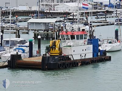
SANDY M
Utility Vessel

Current Trip
LOCH LONG
| Time Travelled | 3 h, 16 mins |
|---|---|
| Remaining Time | --- |
| Distance Travelled | 3.18 nm |
| Remaining Distance | --- |
| AVG Speed | 5.9 Knopen |
| MAX Speed | 7.2 Knopen |
| AVG Wind | 9.7 knots |
| MAX Wind | 11 knots |
| MIN Temp | 9.1°C / 48.38°F |
| MAX Temp | 9.6°C / 49.28°F |
| Diepgang | 2.3 M |
| Positie ontvangen | 1 m geleden |
Current Position
| Lengtegraad | --- |
|---|---|
| Breedtegraat | --- |
| Status | Under way using engine |
| Snelheid | |
| Koers | 188° |
| Gebied | Inner Seas off the West Coast of Scotland |
| Station | T-AIS |
| Positie ontvangen | 1 m geleden |
Information
The current position of SANDY M is in Inner Seas off the West Coast of Scotland with coordinates 56.00096° / -4.75582° as reported on 2025-03-27 13:15 by AIS to our vessel tracker app. The vessel's current speed is 0 Knopen
The vessel SANDY M (IMO: 9640774, MMSI: 235090733) is a Utility Vessel that was built in 2012 ( 13 Jaar oud ). It's sailing under the flag of [GB] United Kingdom.
In this page you can find informations about the vessels current position, last detected port calls, and current voyage information. If the vessels is not in coverage by AIS you will find the latest position.
The current position of SANDY M is detected by our AIS receivers and we are not responsible for the reliability of the data. The last position was recorded while the vessel was in Coverage by the Ais receivers of our vessel tracking app.
The current draught of SANDY M as reported by AIS is 2.3 meters
Weather
| Temperature | 9.6°C / 49.28°F |
|---|---|
| Wind Speed | 12 knots |
| Direction | 210° SSW |
| Pressure | 1007.9 hPa |
| Humidity | 96.2 % |
| Cloud Coverage | 100 % |


Featured Company
Last Port Calls
| Port | Arrival | Departure | Time In Port |
|---|---|---|---|
| 2025-03-27 08:12 | 2025-03-27 10:01 | 1 h | |
| 2025-03-19 15:56 | 2025-03-19 16:28 | 32 m | |
| 2025-03-19 07:34 | 2025-03-19 10:23 | 2 h | |
| 2025-03-18 15:31 | 2025-03-18 15:40 | 9 m | |
| 2025-03-18 11:13 | 2025-03-18 11:30 | 17 m | |
| 2025-03-18 07:45 | 2025-03-18 08:27 | 41 m | |
| 2025-03-14 10:04 | 2025-03-14 10:19 | 15 m | |
| 2025-03-14 04:57 | 2025-03-14 05:05 | 7 m | |
| 2025-03-13 18:25 | 2025-03-13 18:30 | 4 m | |
| 2025-03-13 12:59 | 2025-03-13 13:13 | 13 m |
Last Trips
| Origin | Departure | Destination | Arrival | Distance | |
|---|---|---|---|---|---|
| 2025-03-19 16:28 | 2025-03-27 08:12 | 73.06 nm | |||
| 2025-03-19 10:23 | 2025-03-19 15:56 | 4.28 nm | |||
| 2025-03-18 15:40 | 2025-03-19 07:34 | 2.62 nm | |||
| 2025-03-18 11:30 | 2025-03-18 15:31 | 4.18 nm | |||
| 2025-03-18 08:27 | 2025-03-18 11:13 | 1.93 nm | |||
| 2025-03-14 10:19 | 2025-03-18 07:45 | 39.22 nm | |||
| 2025-03-14 05:05 | 2025-03-14 10:04 | 4.36 nm | |||
| 2025-03-13 18:30 | 2025-03-14 04:57 | 2.15 nm | |||
| 2025-03-13 13:13 | 2025-03-13 18:25 | 4.14 nm | |||
| 2025-03-12 17:57 | 2025-03-13 12:59 | 6.52 nm |
Events
| Tijd | Evenement | Details | Positie / Bestemming | Info |
|---|---|---|---|---|
| 2025-03-27 11:56 | Stop beweging | 0.83 nm, South East of RHU |
56.00097 / -4.75580
LOCH LONG
|
Snelheid: 0.2 kn Koers: 190° |
| 2025-03-27 11:45 | Start beweging | 1.88 nm, South East of RHU |
55.98633 / -4.73862
LOCH LONG
|
Snelheid: 6.2 kn Koers: 337.9° |
| 2025-03-27 10:19 | Stop beweging | 2 nm, South East of RHU |
55.98475 / -4.73656
LOCH LONG
|
Snelheid: 0.3 kn Koers: 254° |
| 2025-03-27 10:01 | Vertrekhaven |
|
56.00913 / -4.77478
LOCH LONG
|
Snelheid: 6.9 kn Koers: 138° |
| 2025-03-27 10:01 | Start beweging |
56.00958 / -4.77554
[GB] RHU
|
Snelheid: 6.9 kn Koers: 137° |
|
| 2025-03-27 08:14 | Stop beweging |
56.01152 / -4.77618
[GB] RHU
|
Snelheid: 0.3 kn Koers: 5° |
|
| 2025-03-27 08:12 | Aankomsthaven |
|
56.01119 / -4.77707
[GB] RHU
|
Snelheid: 2.9 kn Koers: 37° |
| 2025-03-27 08:06 | Start beweging | 0.31 nm, North of ROSNEATH |
56.01072 / -4.79151
LOCH LONG
|
Snelheid: 5.4 kn Koers: 114.9° |
| 2025-03-27 08:01 | Stop beweging | 0.37 nm, North West of ROSNEATH |
56.01113 / -4.79491
LOCH LONG
|
Snelheid: 0.3 kn Koers: 281° |
| 2025-03-27 07:52 | Start beweging | 0.78 nm, North West of ROSNEATH |
56.01694 / -4.80133
LOCH LONG
|
Snelheid: 4.8 kn Koers: 94° |