
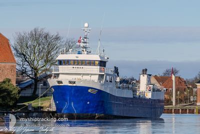
ROBAS
Fish Carrier
Current Trip
FISHFARM
| Time Travelled | 2 days |
|---|---|
| Remaining Time | --- |
| Distance Travelled | 299.17 nm |
| Remaining Distance | --- |
| AVG Speed | 9.1 Knopen |
| MAX Speed | 11.5 Knopen |
| AVG Wind | 7.9 knots |
| MAX Wind | 20 knots |
| MIN Temp | -0.4°C / 31.28°F |
| MAX Temp | 8.5°C / 47.3°F |
| Diepgang | 5.3 M |
| Positie ontvangen | 1 m geleden |
Current Position
| Lengtegraad | --- |
|---|---|
| Breedtegraat | --- |
| Status | Under way using engine |
| Snelheid | 7.6 Knopen |
| Koers | 276.5° |
| Gebied | Skaggerak |
| Station | T-AIS |
| Positie ontvangen | 1 m geleden |
Info
Information
The current position of ROBAS is in Skaggerak with coordinates 57.94964° / 7.51788° as reported on 2026-03-06 15:56 by AIS to our vessel tracker app. The vessel's current speed is 7.6 Knopen
The vessel ROBAS (IMO: 9165487, MMSI: 259488000) is a Fish Carrier that was built in 1998 ( 28 Jaar oud ). It's sailing under the flag of [NO] Norway.
In this page you can find informations about the vessels current position, last detected port calls, and current voyage information. If the vessels is not in coverage by AIS you will find the latest position.
The current position of ROBAS is detected by our AIS receivers and we are not responsible for the reliability of the data. The last position was recorded while the vessel was in Coverage by the Ais receivers of our vessel tracking app.
The current draught of ROBAS as reported by AIS is 5.3 meters
Weather
| Temperature | 6.9°C / 44.42°F |
|---|---|
| Wind Speed | 4 knots |
| Direction | 108° ESE |
| Pressure | 1021.2 hPa |
| Humidity | 82.8 % |
| Cloud Coverage | 4 % |
Featured Company
Last Port Calls
| Port | Arrival | Departure | Time In Port |
|---|---|---|---|
| 2026-03-04 15:30 | 2026-03-04 16:13 | 43 m | |
| 2026-03-02 18:36 | 2026-03-03 16:38 | 22 h | |
| 2026-02-28 05:22 | 2026-03-01 12:38 | 1 d | |
| 2026-02-26 19:27 | 2026-02-26 20:08 | 41 m | |
| 2026-02-21 22:02 | 2026-02-22 08:39 | 10 h | |
| 2026-02-20 19:36 | 2026-02-21 03:59 | 8 h | |
| 2026-02-18 17:41 | 2026-02-19 06:18 | 12 h | |
| 2026-02-13 17:39 | 2026-02-13 17:58 | 19 m | |
| 2026-02-12 21:25 | 2026-02-13 09:47 | 12 h | |
| 2026-02-12 20:36 | 2026-02-12 20:51 | 14 m |
Most Visited Ports (Last year)
| Port | Arrivals | |
|---|---|---|
| 70 | ||
| 22 | ||
| 16 | ||
| 12 | ||
| 11 | ||
| 10 |
Last Trips
| Origin | Departure | Destination | Arrival | Distance | |
|---|---|---|---|---|---|
| 2026-03-03 16:38 | 2026-03-04 15:30 | 48.52 nm | |||
| 2026-03-01 12:38 | 2026-03-02 18:36 | 105.39 nm | |||
| 2026-02-26 20:08 | 2026-02-28 05:22 | 122.13 nm | |||
| 2026-02-22 08:39 | 2026-02-26 19:27 | 345.04 nm | |||
| 2026-02-21 03:59 | 2026-02-21 22:02 | 129.44 nm | |||
| 2026-02-19 06:18 | 2026-02-20 19:36 | 133.66 nm | |||
| 2026-02-13 17:58 | 2026-02-18 17:41 | 303.67 nm | |||
| 2026-02-13 09:47 | 2026-02-13 17:39 | 46.25 nm | |||
| 2026-02-12 20:51 | 2026-02-12 21:25 | 5.53 nm | |||
| 2026-02-12 17:40 | 2026-02-12 20:36 | 29.67 nm |
Events
| Tijd | Evenement | Details | Positie / Bestemming | Info |
|---|---|---|---|---|
| 2026-03-06 12:33 | Start beweging | --- |
58.13902 / 8.25768
FISHFARM
|
Snelheid: 3.8 kn Koers: 162° |
| 2026-03-06 10:45 | Stop beweging | --- |
58.14077 / 8.25630
FISHFARM
|
Snelheid: Koers: 168° |
| 2026-03-06 06:25 | Wijzig zee gebeid | Norwegian part of the Skaggerak Norwegian part of the North Sea |
57.97023 / 7.06250
Skaggerak
|
Snelheid: 9.8 kn Koers: 90.5° |
| 2026-03-05 15:00 | Start beweging | --- |
59.89625 / 5.11567
FISHFARM
|
Snelheid: 6.7 kn Koers: 88.3° |
| 2026-03-05 14:04 | Stop beweging | --- |
59.89628 / 5.10469
FISHFARM
|
Snelheid: 0.1 kn Koers: 138° |
| 2026-03-05 09:03 | Binnenbereik |
60.12542 / 5.92791
North Sea
|
Snelheid: 1.6 kn Koers: 244.8° |
|
| 2026-03-05 07:05 | Buitenbereik |
60.12582 / 5.92894
North Sea
|
Snelheid: 1 kn Koers: 82.7° |
|
| 2026-03-05 05:19 | Stop beweging | --- |
60.12696 / 5.93124
FISHFARM
|
Snelheid: Koers: 38° |
| 2026-03-05 05:09 | Binnenbereik |
60.12304 / 5.92519
North Sea
|
Snelheid: 0.7 kn Koers: 33.9° |
|
| 2026-03-04 18:40 | Buitenbereik |
60.06213 / 5.93844
North Sea
FISHFARM
|
Snelheid: 10.4 kn Koers: 359.9° |