
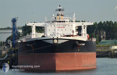
RHYTHMIC
Tanker
Current Trip
| Time Travelled | 20 days |
|---|---|
| Remaining Time | 5 days |
| Distance Travelled | 4198.47 nm |
| Remaining Distance | 1698.91 nm |
| AVG Speed | 11.3 Knopen |
| MAX Speed | 14.5 Knopen |
| AVG Wind | 16.1 knots |
| MAX Wind | 31 knots |
| MIN Temp | 6.4°C / 43.52°F |
| MAX Temp | 20.3°C / 68.54°F |
| Diepgang | 15.1 M |
| Positie ontvangen | 7 h, 34 m geleden |
Current Position
| Lengtegraad | --- |
|---|---|
| Breedtegraat | --- |
| Status | Under way using engine |
| Snelheid | 12.1 Knopen |
| Koers | 14.5° |
| Gebied | North Atlantic Ocean |
| Station | T-AIS |
| Positie ontvangen | 7 h, 34 m geleden |
Info
Information
The current position of RHYTHMIC is in North Atlantic Ocean with coordinates 28.74963° / -14.74990° as reported on 2025-02-17 00:37 by AIS to our vessel tracker app. The vessel's current speed is 12.1 Knopen and is heading at the port of ROTTERDAM. The estimated time of arrival as calculated by MyShipTracking vessel tracking app is 2025-02-23 00:53 LT
The vessel RHYTHMIC (IMO: 9819856, MMSI: 241659000) is a Tanker It's sailing under the flag of [GR] Greece.
In this page you can find informations about the vessels current position, last detected port calls, and current voyage information. If the vessels is not in coverage by AIS you will find the latest position.
The current position of RHYTHMIC is detected by our AIS receivers and we are not responsible for the reliability of the data. The last position was recorded while the vessel was in Coverage by the Ais receivers of our vessel tracking app.
The current draught of RHYTHMIC as reported by AIS is 15.1 meters
Weather
| Temperature | 16.7°C / 62.06°F |
|---|---|
| Wind Speed | 3 knots |
| Direction | 106° ESE |
| Pressure | 1016.8 hPa |
| Humidity | 61 % |
| Cloud Coverage | --- |
Featured Company
Last Port Calls
| Port | Arrival | Departure | Time In Port |
|---|---|---|---|
| 2025-01-26 12:56 | 2025-01-27 17:41 | 1 d | |
| 2025-01-24 17:09 | 2025-01-25 10:06 | 16 h | |
| 2024-12-23 14:06 | 2024-12-24 18:29 | 1 d | |
| 2024-12-01 14:23 | 2024-12-01 15:05 | 42 m |
Last Trips
| Origin | Departure | Destination | Arrival | Distance | |
|---|---|---|---|---|---|
| 2025-01-25 11:06 | 2025-01-26 13:56 | 301.68 nm | |||
| 2024-12-24 19:29 | 2025-01-24 18:09 | 8100.29 nm | |||
| 2024-12-01 09:05 | 2024-12-23 15:06 | 5533.79 nm | |||
| 2024-11-28 14:23 | 2024-12-01 08:23 | 7.65 nm |
Events
| Tijd | Evenement | Details | Positie / Bestemming | Info |
|---|---|---|---|---|
| 2025-02-17 00:43 | Status Changed | Default Under way using engine |
28.76872 / -14.74624
ROTTERDAM
|
Snelheid: 12.1 kn Koers: 14.5° |
| 2025-02-17 00:37 | Status Changed | Under way using engine Default |
28.74963 / -14.74990
ROTTERDAM
|
Snelheid: 12.1 kn Koers: 10° |
| 2025-02-17 00:37 | Buitenbereik |
28.74963 / -14.74990
North Atlantic Ocean
ROTTERDAM
|
Snelheid: 12.1 kn Koers: 14.5° |
|
| 2025-02-17 00:27 | Status Changed | Default Under way using engine |
28.71633 / -14.75590
ROTTERDAM
|
Snelheid: 11.8 kn Koers: 6.9° |
| 2025-02-16 18:02 | Draught Changed | 15.1 9 |
27.48373 / -15.17165
ROTTERDAM
|
Snelheid: 12.4 kn Koers: 17.9° |
| 2025-02-16 18:02 | Destination Changed | ROTTERDAM ESLPA |
27.48373 / -15.17165
ROTTERDAM
|
Snelheid: 12.4 kn Koers: 17.9° |
| 2025-02-16 18:02 | ETA Changed | 2025/02/23 03:00 2025/02/03 23:00 |
27.48373 / -15.17165
ROTTERDAM
|
Snelheid: 12.4 kn Koers: 17.9° |
| 2025-02-16 17:48 | Status Changed | Under way using engine Default |
27.45736 / -15.18179
ESLPA
|
Snelheid: 12.6 kn Koers: 20° |
| 2025-02-16 17:31 | Status Changed | Default Under way using engine |
27.40268 / -15.20225
ESLPA
|
Snelheid: 12.7 kn Koers: 18.8° |
| 2025-02-16 17:26 | Status Changed | Under way using engine Default |
27.38351 / -15.20947
ESLPA
|
Snelheid: 12.8 kn Koers: 18° |