
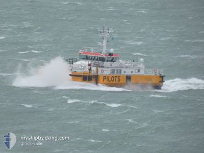
PERSEUS (PILOTS)
Pilot Ship
Current Trip
| Trip Time | 1 day |
|---|---|
| Trip Distance | 330.88 nm |
| AVG Speed | 9.5 Knopen |
| MAX Speed | 9.5 Knopen |
| Diepgang | 3 M |
| AVG Wind | 20.8 knots |
| MAX Wind | 34.8 knots |
| MIN Temp | 8.2°C / 46.76°F |
| MAX Temp | 12°C / 53.6°F |
| Positie ontvangen | 1 m geleden |
Current Position
| Lengtegraad | --- |
|---|---|
| Breedtegraat | --- |
| Status | Moored |
| Snelheid | 0.2 Knopen |
| Koers | 297° |
| Gebied | North Sea |
| Station | T-AIS |
| Positie ontvangen | 1 m geleden |
Info
Information
The current position of PERSEUS (PILOTS) is in North Sea with coordinates 51.44367° / 3.59817° as reported on 2024-11-30 12:34 by AIS to our vessel tracker app. The vessel's current speed is 0.2 Knopen and is currently inside the port of VLISSINGEN STATION.
The vessel PERSEUS (PILOTS) (IMO: 9367114, MMSI: 246390000) is a Pilot Ship that was built in 2006 ( 18 Jaar oud ). It's sailing under the flag of [NL] Netherlands.
In this page you can find informations about the vessels current position, last detected port calls, and current voyage information. If the vessels is not in coverage by AIS you will find the latest position.
The current position of PERSEUS (PILOTS) is detected by our AIS receivers and we are not responsible for the reliability of the data. The last position was recorded while the vessel was in Coverage by the Ais receivers of our vessel tracking app.
The current draught of PERSEUS (PILOTS) as reported by AIS is 3 meters
Weather
| Temperature | 7.5°C / 45.5°F |
|---|---|
| Wind Speed | 10 knots |
| Direction | 193° SSW |
| Pressure | 1026.4 hPa |
| Humidity | 63.4 % |
| Cloud Coverage | 88 % |
Featured Company
Last Port Calls
| Port | Arrival | Departure | Time In Port |
|---|---|---|---|
| 2024-11-28 04:00 | |||
| 2024-11-26 09:08 | 2024-11-26 09:38 | 30 m | |
| 2024-11-24 13:21 | 2024-11-25 05:28 | 16 h | |
| 2024-11-20 16:04 | 2024-11-24 10:41 | 3 d | |
| 2024-11-20 08:19 | 2024-11-20 10:43 | 2 h | |
| 2024-11-19 12:07 | 2024-11-19 14:08 | 2 h | |
| 2024-11-18 05:05 | 2024-11-18 08:31 | 3 h | |
| 2024-11-12 12:58 | 2024-11-12 14:05 | 1 h | |
| 2024-11-07 04:45 | 2024-11-07 08:45 | 3 h | |
| 2024-11-04 04:39 | 2024-11-04 05:40 | 1 h |
Most Visited Ports (Last year)
| Port | Arrivals | |
|---|---|---|
| 82 | ||
| 3 | ||
| 1 |
Last Trips
| Origin | Departure | Destination | Arrival | Distance | |
|---|---|---|---|---|---|
| 2024-11-26 10:38 | 2024-11-28 05:00 | 330.88 nm | |||
| 2024-11-25 06:28 | 2024-11-26 10:08 | 239.08 nm | |||
| 2024-11-24 11:41 | 2024-11-24 14:21 | 40.39 nm | |||
| 2024-11-20 11:43 | 2024-11-20 17:04 | 57.43 nm | |||
| 2024-11-19 15:08 | 2024-11-20 09:19 | 120.31 nm | |||
| 2024-11-18 09:31 | 2024-11-19 13:07 | 210.31 nm | |||
| 2024-11-12 15:05 | 2024-11-18 06:05 | 956.77 nm | |||
| 2024-11-07 09:45 | 2024-11-12 13:58 | 788.08 nm | |||
| 2024-11-04 06:40 | 2024-11-07 05:45 | 471.69 nm | |||
| 2024-11-03 09:23 | 2024-11-04 05:39 | 138.51 nm |
Events
| Tijd | Evenement | Details | Positie / Bestemming | Info |
|---|---|---|---|---|
| 2024-11-28 08:11 | Status Changed | Moored Under way using engine |
51.44367 / 3.59817
[NL] VLISSINGEN STATION
|
Snelheid: 0.1 kn Koers: 298° |
| 2024-11-28 04:00 | Stop beweging |
51.44350 / 3.59850
[NL] VLISSINGEN STATION
|
Snelheid: 0.1 kn Koers: 286° |
|
| 2024-11-28 04:00 | Aankomsthaven |
|
51.44350 / 3.59850
[NL] VLISSINGEN STATION
|
Snelheid: 0.6 kn Koers: 288° |
| 2024-11-27 19:47 | Start beweging | 0.87 nm, South East of VLISSINGEN STATION |
51.43517 / 3.60267
PILOT BOARDING AREA
|
Snelheid: 3.1 kn Koers: 272° |
| 2024-11-27 19:40 | Stop beweging | 1.01 nm, South East of VLISSINGEN STATION |
51.43350 / 3.60583
PILOT BOARDING AREA
|
Snelheid: 0.3 kn Koers: 288° |
| 2024-11-27 12:06 | Start beweging | 14.86 nm, North West of OOSTWATERING |
51.68883 / 3.31217
PILOT BOARDING AREA
|
Snelheid: 9.5 kn Koers: 229° |
| 2024-11-27 12:04 | Stop beweging | 14.86 nm, North West of OOSTWATERING |
51.69117 / 3.31467
PILOT BOARDING AREA
|
Snelheid: 0.2 kn Koers: 188° |
| 2024-11-27 11:43 | Start beweging | 16.33 nm, North West of OOSTWATERING |
51.70083 / 3.27767
PILOT BOARDING AREA
|
Snelheid: 3.8 kn Koers: 149° |
| 2024-11-27 11:38 | Stop beweging | 16.43 nm, North West of OOSTWATERING |
51.70250 / 3.27633
PILOT BOARDING AREA
|
Snelheid: 0.1 kn Koers: 197° |
| 2024-11-26 20:23 | Start beweging | 16.34 nm, North West of NEELTJE JANS |
51.73617 / 3.30333
PILOT BOARDING AREA
|
Snelheid: 5.7 kn Koers: 278° |