
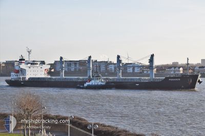
PEGASUS
Cargo
Current Trip
| Time Travelled | 13 days |
|---|---|
| Remaining Time | --- |
| Distance Travelled | 1413.46 nm |
| Remaining Distance | --- |
| AVG Speed | 9.8 Knopen |
| MAX Speed | 18.8 Knopen |
| AVG Wind | 18.9 knots |
| MAX Wind | 29 knots |
| MIN Temp | -5.7°C / 21.74°F |
| MAX Temp | 6.4°C / 43.52°F |
| Diepgang | 6.7 M |
| Positie ontvangen | 4 h, 27 m geleden |
Current Position
| Lengtegraad | --- |
|---|---|
| Breedtegraat | --- |
| Status | At anchor |
| Snelheid | 4.7 Knopen |
| Koers | 86° |
| Gebied | Gulf of Finland |
| Station | T-AIS |
| Positie ontvangen | 4 h, 27 m geleden |
Info
Information
The current position of PEGASUS is in Gulf of Finland with coordinates 60.10005° / 29.33095° as reported on 2025-01-21 02:39 by AIS to our vessel tracker app. The vessel's current speed is 4.7 Knopen
The vessel PEGASUS (IMO: 9755842, MMSI: 319144400) is a Cargo It's sailing under the flag of [KY] Cayman Is.
In this page you can find informations about the vessels current position, last detected port calls, and current voyage information. If the vessels is not in coverage by AIS you will find the latest position.
The current position of PEGASUS is detected by our AIS receivers and we are not responsible for the reliability of the data. The last position was recorded while the vessel was in Coverage by the Ais receivers of our vessel tracking app.
The current draught of PEGASUS as reported by AIS is 6.7 meters
Weather
| Temperature | -5.5°C / 22.1°F |
|---|---|
| Wind Speed | 10 knots |
| Direction | 69° ENE |
| Pressure | 1030.7 hPa |
| Humidity | 58.8 % |
| Cloud Coverage | 100 % |
Featured Company
Last Port Calls
| Port | Arrival | Departure | Time In Port |
|---|---|---|---|
| 2024-12-31 23:00 | 2025-01-07 19:16 | 6 d | |
| 2024-12-14 12:27 | 2024-12-27 12:44 | 13 d | |
| 2024-11-12 21:52 | 2024-11-18 05:55 | 5 d | |
| 2024-11-01 21:24 |
Most Visited Ports (Last year)
| Port | Arrivals | |
|---|---|---|
| 3 | ||
| 2 | ||
| 1 | ||
| 1 | ||
| 1 | ||
| 1 |
Last Trips
| Origin | Departure | Destination | Arrival | Distance | |
|---|---|---|---|---|---|
| 2024-12-27 13:44 | 2025-01-01 00:00 | 1007.98 nm | |||
| 2024-11-18 06:55 | 2024-12-14 13:27 | 3393.79 nm | |||
| 2024-11-02 00:24 | 2024-11-12 22:52 | 2811.81 nm |
Events
| Tijd | Evenement | Details | Positie / Bestemming | Info |
|---|---|---|---|---|
| 2025-01-21 02:39 | Buitenbereik |
60.10005 / 29.33095
Gulf of Finland
|
Snelheid: 4.7 kn Koers: 326.7° |
|
| 2025-01-21 01:28 | Status Changed | At anchor Default |
60.09951 / 29.33153
RULED
|
Snelheid: 3.1 kn Koers: 77° |
| 2025-01-21 00:53 | Status Changed | Default At anchor |
60.09976 / 29.33246
RULED
|
Snelheid: 0.2 kn Koers: 74° |
| 2025-01-21 00:24 | Status Changed | At anchor Default |
60.09963 / 29.33124
RULED
|
Snelheid: 5.7 kn Koers: 68° |
| 2025-01-20 23:50 | Status Changed | Default At anchor |
60.09920 / 29.33214
RULED
|
Snelheid: 0.4 kn Koers: 62° |
| 2025-01-20 22:50 | Status Changed | At anchor Default |
60.09893 / 29.33252
RULED
|
Snelheid: 0.2 kn Koers: 58° |
| 2025-01-20 22:50 | Binnenbereik |
60.09893 / 29.33252
Gulf of Finland
|
Snelheid: 1.5 kn Koers: 137.3° |
|
| 2025-01-20 20:35 | Status Changed | Default At anchor |
60.09839 / 29.33351
RULED
|
Snelheid: 2.3 kn Koers: 64° |
| 2025-01-20 20:35 | Status Changed | At anchor Default |
60.09864 / 29.33315
RULED
|
Snelheid: 4.7 kn Koers: 62° |
| 2025-01-20 20:35 | Buitenbereik |
60.09864 / 29.33315
Gulf of Finland
|
Snelheid: 2.3 kn Koers: 119.1° |