
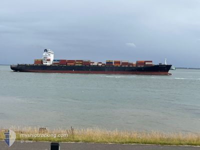
OOCL ST.LAWRENCE
Container Ship
Current Trip
| Time Travelled | 14 days |
|---|---|
| Remaining Time | 2 days |
| Distance Travelled | 2851.11 nm |
| Remaining Distance | 680.69 nm |
| AVG Speed | 10.6 Knopen |
| MAX Speed | 21.2 Knopen |
| AVG Wind | 18.2 knots |
| MAX Wind | 38 knots |
| MIN Temp | -9.1°C / 15.62°F |
| MAX Temp | 13.6°C / 56.48°F |
| Diepgang | 9.5 M |
| Positie ontvangen | 13 d geleden |
Current Position
| Lengtegraad | --- |
|---|---|
| Breedtegraat | --- |
| Status | Under way using engine |
| Snelheid | 14.6 Knopen |
| Koers | 252.4° |
| Gebied | Celtic Sea |
| Station | T-AIS |
| Positie ontvangen | 13 d geleden |
Info
Information
The current position of OOCL ST.LAWRENCE is in Celtic Sea with coordinates 51.23926° / -10.07692° as reported on 2025-12-24 00:40 by AIS to our vessel tracker app. The vessel's current speed is 14.6 Knopen and is heading at the port of MONTREAL. The estimated time of arrival as calculated by MyShipTracking vessel tracking app is 2026-01-08 02:25 LT
The vessel OOCL ST.LAWRENCE (IMO: 9290414, MMSI: 538010806) is a Container Ship that was built in 2005 ( 21 Jaar oud ). It's sailing under the flag of [MH] Marshall Is.
In this page you can find informations about the vessels current position, last detected port calls, and current voyage information. If the vessels is not in coverage by AIS you will find the latest position.
The current position of OOCL ST.LAWRENCE is detected by our AIS receivers and we are not responsible for the reliability of the data. The last position was recorded while the vessel was in Coverage by the Ais receivers of our vessel tracking app.
The current draught of OOCL ST.LAWRENCE as reported by AIS is 9.5 meters
Weather
| Temperature | -7.5°C / 18.5°F |
|---|---|
| Wind Speed | 23 knots |
| Direction | 274° W |
| Pressure | 1014.7 hPa |
| Humidity | 83.3 % |
| Cloud Coverage | 100 % |
Featured Company
Last Port Calls
| Port | Arrival | Departure | Time In Port |
|---|---|---|---|
| 2025-12-22 00:39 | 2025-12-23 00:03 | 23 h | |
| 2025-12-18 21:14 | 2025-12-19 12:02 | 14 h | |
| 2025-12-16 17:52 | 2025-12-17 10:46 | 16 h | |
| 2025-12-13 07:14 | 2025-12-14 08:56 | 1 d | |
| 2025-11-28 07:09 | 2025-11-30 01:49 | 1 d | |
| 2025-11-17 09:31 | 2025-11-18 08:04 | 22 h | |
| 2025-11-15 01:09 | 2025-11-15 21:10 | 20 h | |
| 2025-11-13 08:29 | 2025-11-14 06:32 | 22 h | |
| 2025-11-01 02:29 |
Last Trips
| Origin | Departure | Destination | Arrival | Distance | |
|---|---|---|---|---|---|
| 2025-12-19 12:02 | 2025-12-22 00:39 | 534.13 nm | |||
| 2025-12-17 10:46 | 2025-12-18 21:14 | 489.48 nm | |||
| 2025-12-14 08:56 | 2025-12-16 17:52 | 350.83 nm | |||
| 2025-11-30 01:49 | 2025-12-13 07:14 | 4331.06 nm | |||
| 2025-11-18 08:04 | 2025-11-28 07:09 | 3001.55 nm | |||
| 2025-11-15 21:10 | 2025-11-17 09:31 | 534.84 nm | |||
| 2025-11-14 06:32 | 2025-11-15 01:09 | 272.71 nm | |||
| 2025-11-01 02:29 | 2025-11-13 08:29 | 3162.70 nm |
Events
| Tijd | Evenement | Details | Positie / Bestemming | Info |
|---|---|---|---|---|
| 2026-01-02 02:00 | Start beweging |
47.02466 / -57.68149
CAMTR
|
Snelheid: 4.1 kn Koers: 174° |
|
| 2026-01-01 05:03 | Stop beweging |
46.71833 / -57.45167
CAMTR
|
Snelheid: Koers: -1° |
|
| 2026-01-01 03:05 | Start beweging |
46.98680 / -57.29415
CAMTR
|
Snelheid: 3.5 kn Koers: 246° |
|
| 2025-12-31 18:17 | Stop beweging |
46.78423 / -57.54077
CAMTR
|
Snelheid: 0.2 kn Koers: 225° |