
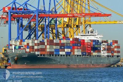
ONTARIO EXPRESS
Container Ship
Current Trip
| Trip Time | 9 days |
|---|---|
| Trip Distance | 3442.54 nm |
| AVG Speed | 13.5 Knopen |
| MAX Speed | 13.5 Knopen |
| Diepgang | 10.8 M |
| AVG Wind | 8.4 knots |
| MAX Wind | 28 knots |
| MIN Temp | 1.2°C / 34.16°F |
| MAX Temp | 17.8°C / 64.04°F |
| Positie ontvangen | 5 m geleden |
Current Position
| Lengtegraad | -73.50453° |
|---|---|
| Breedtegraat | 45.58998° |
| Status | Moored |
| Snelheid | |
| Koers | 167° |
| Gebied | Gulf of St-Lawrence |
| Station | T-AIS |
| Positie ontvangen | 5 m geleden |
Info
Information
The current position of ONTARIO EXPRESS is in Gulf of St-Lawrence with coordinates 45.58998° / -73.50453° as reported on 2024-05-16 23:53 by AIS to our vessel tracker app. The vessel's current speed is 0 Knopen and is currently inside the port of MONTREAL.
The vessel ONTARIO EXPRESS (IMO: 9290816, MMSI: 310761000) is a Container Ship that was built in 2005 ( 19 Jaar oud ). It's sailing under the flag of [BM] Bermuda.
In this page you can find informations about the vessels current position, last detected port calls, and current voyage information. If the vessels is not in coverage by AIS you will find the latest position.
The current position of ONTARIO EXPRESS is detected by our AIS receivers and we are not responsible for the reliability of the data. The last position was recorded while the vessel was in Coverage by the Ais receivers of our vessel tracking app.
The current draught of ONTARIO EXPRESS as reported by AIS is 10.8 meters
Weather
| Temperature | 19.9°C / 67.82°F |
|---|---|
| Wind Speed | 4 knots |
| Direction | 46° NE |
| Pressure | 1012 hPa |
| Humidity | 71 % |
| Cloud Coverage | 7 % |
Featured Company
Last Port Calls
| Port | Arrival | Departure | Time In Port |
|---|---|---|---|
| 2024-05-14 00:22 | |||
| 2024-05-03 03:27 | 2024-05-04 07:01 | 1 d | |
| 2024-04-26 14:22 | 2024-04-27 11:16 | 20 h | |
| 2024-04-24 01:01 | 2024-04-24 19:48 | 18 h | |
| 2024-04-08 20:29 | 2024-04-12 12:35 | 3 d | |
| 2024-03-26 12:20 | 2024-03-27 12:55 | 1 d | |
| 2024-03-21 19:09 | 2024-03-22 13:02 | 17 h | |
| 2024-03-20 01:24 | 2024-03-20 18:35 | 17 h | |
| 2024-03-05 17:03 | 2024-03-08 13:00 | 2 d |
Most Visited Ports (Last year)
| Port | Arrivals | |
|---|---|---|
| 9 | ||
| 9 | ||
| 9 | ||
| 8 | ||
| 2 |
Last Trips
| Origin | Departure | Destination | Arrival | Distance | |
|---|---|---|---|---|---|
| 2024-05-04 09:01 | 2024-05-13 20:22 | 3442.54 nm | |||
| 2024-04-27 13:16 | 2024-05-03 05:27 | 430.03 nm | |||
| 2024-04-24 20:48 | 2024-04-26 16:22 | 292.78 nm | |||
| 2024-04-12 08:35 | 2024-04-24 02:01 | 3143.80 nm | |||
| 2024-03-27 13:55 | 2024-04-08 16:29 | 3593.30 nm | |||
| 2024-03-22 14:02 | 2024-03-26 13:20 | 500.78 nm | |||
| 2024-03-20 18:35 | 2024-03-21 20:09 | 281.24 nm | |||
| 2024-03-08 08:00 | 2024-03-20 01:24 | 3191.30 nm | |||
| 2024-02-20 20:32 | 2024-03-05 12:03 | 3873.65 nm |
Events
| Tijd | Evenement | Details | Positie / Bestemming | Info |
|---|---|---|---|---|
| 2024-05-14 11:47 | Status Changed | Moored Default |
45.59002 / -73.50453
[CA] MONTREAL
|
Snelheid: Koers: 166° |
| 2024-05-14 11:45 | Status Changed | Default Moored |
45.59004 / -73.50449
[CA] MONTREAL
|
Snelheid: Koers: 166° |
| 2024-05-14 01:20 | Status Changed | Moored Under way using engine |
45.59003 / -73.50453
[CA] MONTREAL
|
Snelheid: 0.1 kn Koers: 167° |
| 2024-05-14 01:06 | Stop beweging |
45.59054 / -73.50459
[CA] MONTREAL
|
Snelheid: 0.3 kn Koers: 167° |
|
| 2024-05-14 00:22 | Aankomsthaven |
|
45.63032 / -73.48991
[CA] MONTREAL
|
Snelheid: 5.2 kn Koers: 209.7° |
| 2024-05-13 19:53 | Status Changed | Under way using engine Default |
46.19904 / -72.86619
CAMTR
|
Snelheid: 11.1 kn Koers: 249° |
| 2024-05-13 19:50 | Status Changed | Default Under way using engine |
46.20207 / -72.85362
CAMTR
|
Snelheid: 11.4 kn Koers: 240.5° |
| 2024-05-13 19:19 | Status Changed | Under way using engine Default |
46.25260 / -72.72914
CAMTR
|
Snelheid: 10.8 kn Koers: 240° |
| 2024-05-13 18:58 | Status Changed | Default Under way using engine |
46.26400 / -72.64625
CAMTR
|
Snelheid: 9.4 kn Koers: 235.1° |
| 2024-05-13 18:50 | Status Changed | Under way using engine Default |
46.27586 / -72.61879
CAMTR
|
Snelheid: 9.6 kn Koers: 232° |