
ODEN
Icebreaker
Current Trip
| Time Travelled | 2 days |
|---|---|
| Remaining Time | 1 day |
| Distance Travelled | 600.68 nm |
| Remaining Distance | 327.04 nm |
| AVG Speed | 8.5 Knopen |
| MAX Speed | 11.8 Knopen |
| AVG Wind | 18.5 knots |
| MAX Wind | 33 knots |
| MIN Temp | -7.8°C / 17.96°F |
| MAX Temp | 3.7°C / 38.66°F |
| Diepgang | 8.5 M |
| Positie ontvangen | 31 m geleden |
Current Position
| Lengtegraad | --- |
|---|---|
| Breedtegraat | --- |
| Status | Under way using engine |
| Snelheid | 11.5 Knopen |
| Koers | 188° |
| Gebied | Baltic Sea |
| Station | T-AIS |
| Positie ontvangen | 31 m geleden |
Info
Information
The current position of ODEN is in Baltic Sea with coordinates 58.26174° / 17.46524° as reported on 2025-03-17 13:38 by AIS to our vessel tracker app. The vessel's current speed is 11.5 Knopen and is heading at the port of HELSINGBORG. The estimated time of arrival as calculated by MyShipTracking vessel tracking app is 2025-03-18 19:27 LT
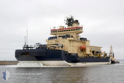
The vessel ODEN (IMO: 8700876, MMSI: 265182000) is a Icebreaker that was built in 1989 ( 36 Jaar oud ). It's sailing under the flag of [SE] Sweden.
In this page you can find informations about the vessels current position, last detected port calls, and current voyage information. If the vessels is not in coverage by AIS you will find the latest position.
The current position of ODEN is detected by our AIS receivers and we are not responsible for the reliability of the data. The last position was recorded while the vessel was in Coverage by the Ais receivers of our vessel tracking app.
The current draught of ODEN as reported by AIS is 8.5 meters
Weather
| Temperature | 3.7°C / 38.66°F |
|---|---|
| Wind Speed | 17 knots |
| Direction | 278° W |
| Pressure | 1024.2 hPa |
| Humidity | 59.1 % |
| Cloud Coverage | 49 % |
Featured Company
Last Port Calls
| Port | Arrival | Departure | Time In Port |
|---|---|---|---|
| 2025-03-12 10:54 | 2025-03-14 19:39 | 2 d | |
| 2025-02-26 15:56 | 2025-02-28 14:37 | 1 d | |
| 2025-02-12 12:32 | 2025-02-14 10:46 | 1 d | |
| 2025-02-08 10:11 |
Most Visited Ports (Last year)
| Port | Arrivals | |
|---|---|---|
| 7 | ||
| 2 | ||
| 1 |
Events
| Tijd | Evenement | Details | Positie / Bestemming | Info |
|---|---|---|---|---|
| 2025-03-17 13:46 | Status Changed | Default Under way using engine |
58.23604 / 17.46042
SEHEL
|
Snelheid: 11.5 kn Koers: 188° |
| 2025-03-17 11:13 | Draught Changed | 8.5 8 |
58.57509 / 17.59719
SEHEL
|
Snelheid: 5.4 kn Koers: 320° |
| 2025-03-17 11:13 | ETA Changed | 2025/03/19 08:00 |
58.57509 / 17.59719
SEHEL
|
Snelheid: 5.4 kn Koers: 320° |
| 2025-03-17 11:07 | Draught Changed | 8 8.5 |
58.56620 / 17.59864
SEHEL
|
Snelheid: 5.7 kn Koers: 17° |
| 2025-03-17 09:21 | Status Changed | Under way using engine Not under command |
58.60693 / 17.72340
SEHEL
|
Snelheid: 1.1 kn Koers: 9° |
| 2025-03-17 06:35 | Status Changed | Not under command Under way using engine |
58.59917 / 17.64369
SEHEL
|
Snelheid: 1 kn Koers: 23° |
| 2025-03-17 00:03 | Status Changed | Under way using engine Default |
58.96019 / 18.94719
SEHEL
|
Snelheid: 8.5 kn Koers: 220° |
| 2025-03-17 00:02 | Status Changed | Default Under way using engine |
58.96279 / 18.95195
SEHEL
|
Snelheid: 8.7 kn Koers: 223.3° |
| 2025-03-16 23:55 | Status Changed | Under way using engine Default |
58.97427 / 18.97272
SEHEL
|
Snelheid: 8.7 kn Koers: 221° |
| 2025-03-16 23:38 | Status Changed | Default Under way using engine |
59.00547 / 19.02815
SEHEL
|
Snelheid: 8.7 kn Koers: 221.4° |