
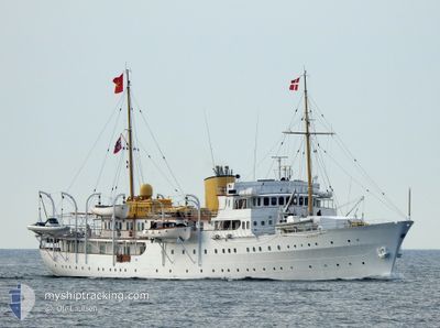
NORGE
Military ops
Current Trip
TROMOEY
| Time Travelled | 10 days |
|---|---|
| Remaining Time | --- |
| Distance Travelled | 916.61 nm |
| Remaining Distance | --- |
| AVG Speed | 12 Knopen |
| MAX Speed | 16.4 Knopen |
| AVG Wind | 12.2 knots |
| MAX Wind | 27.8 knots |
| MIN Temp | -5°C / 23°F |
| MAX Temp | 13.1°C / 55.58°F |
| Diepgang | 5 M |
| Positie ontvangen | 2 m geleden |
Current Position
| Lengtegraad | --- |
|---|---|
| Breedtegraat | --- |
| Status | At anchor |
| Snelheid | |
| Koers | 75° |
| Gebied | Skaggerak |
| Station | T-AIS |
| Positie ontvangen | 2 m geleden |
Information
The current position of NORGE is in Skaggerak with coordinates 58.43348° / 8.80232° as reported on 2025-04-07 11:02 by AIS to our vessel tracker app. The vessel's current speed is 0 Knopen
The vessel NORGE (MMSI: 257001000) is a Military ops It's sailing under the flag of [NO] Norway.
In this page you can find informations about the vessels current position, last detected port calls, and current voyage information. If the vessels is not in coverage by AIS you will find the latest position.
The current position of NORGE is detected by our AIS receivers and we are not responsible for the reliability of the data. The last position was recorded while the vessel was in Coverage by the Ais receivers of our vessel tracking app.
The current draught of NORGE as reported by AIS is 5 meters
Weather
| Temperature | 10.6°C / 51.08°F |
|---|---|
| Wind Speed | 6 knots |
| Direction | 82° E |
| Pressure | 1026.7 hPa |
| Humidity | 49.6 % |
| Cloud Coverage | 3 % |
Featured Company
Most Visited Ports (Last year)
| Port | Arrivals | |
|---|---|---|
| 8 | ||
| 5 | ||
| 4 | ||
| 2 | ||
| 2 | ||
| 1 |
Last Trips
| Origin | Departure | Destination | Arrival | Distance |
|---|
Events
| Tijd | Evenement | Details | Positie / Bestemming | Info |
|---|---|---|---|---|
| 2025-04-07 06:11 | Status Changed | At anchor Under way using engine |
58.43338 / 8.80412
TROMOEY
|
Snelheid: 0.4 kn Koers: 320° |
| 2025-04-07 06:11 | Stop beweging | 1.81 nm, South East of ARENDAL |
58.43338 / 8.80412
TROMOEY
|
Snelheid: 0.1 kn Koers: 315° |
| 2025-04-07 01:01 | Gevonden in zee | Norwegian part of the Skaggerak |
57.92394 / 7.13038
Skaggerak
TROMOEY
|
Snelheid: 13.5 kn Koers: 102.2° |
| 2025-04-06 16:48 | Start beweging | 2.05 nm, South of MORTAVIKA |
59.10768 / 5.61259
TROMOEY
|
Snelheid: 3.2 kn Koers: 334° |
| 2025-04-06 16:37 | Status Changed | Under way using engine At anchor |
59.10292 / 5.61382
TROMOEY
|
Snelheid: 0.9 kn Koers: 322° |
| 2025-04-06 16:37 | Destination Changed | TROMOEY KLOSTERHEIM |
59.10271 / 5.61418
TROMOEY
|
Snelheid: 0.9 kn Koers: 322° |
| 2025-04-06 16:37 | ETA Changed | 2025/04/07 06:00 2025/04/05 06:00 |
59.10271 / 5.61418
TROMOEY
|
Snelheid: 0.9 kn Koers: 322° |
| 2025-04-06 05:40 | Status Changed | At anchor Under way using engine |
59.10324 / 5.61404
KLOSTERHEIM
|
Snelheid: 0.8 kn Koers: 254° |
| 2025-04-06 05:39 | Stop beweging | 2.32 nm, South of MORTAVIKA |
59.10314 / 5.61376
KLOSTERHEIM
|
Snelheid: 0.3 kn Koers: 255° |
| 2025-04-05 17:12 | Start beweging | 6.58 nm, South West of GJERMUNDSHAMN |
59.99370 / 5.74978
KLOSTERHEIM
|
Snelheid: 5.5 kn Koers: 322.9° |