
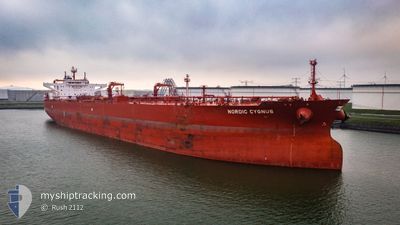
NORDIC CYGNUS
Tanker
Current Trip
| Time Travelled | 15 days |
|---|---|
| Remaining Time | --- |
| Distance Travelled | 2787.71 nm |
| Remaining Distance | --- |
| AVG Speed | 8.5 Knopen |
| MAX Speed | 14.8 Knopen |
| AVG Wind | 11.1 knots |
| MAX Wind | 32.8 knots |
| MIN Temp | 2.2°C / 35.96°F |
| MAX Temp | 14.8°C / 58.64°F |
| Diepgang | 9.3 M |
| Positie ontvangen | 6 d geleden |
Current Position
| Lengtegraad | -4.55995° |
|---|---|
| Breedtegraat | 49.60077° |
| Status | Under way using engine |
| Snelheid | 11 Knopen |
| Koers | 249.2° |
| Gebied | English Channel |
| Station | T-AIS |
| Positie ontvangen | 6 d geleden |
Info
Information
The current position of NORDIC CYGNUS is in English Channel with coordinates 49.60077° / -4.55995° as reported on 2024-04-25 01:08 by AIS to our vessel tracker app. The vessel's current speed is 11 Knopen and is heading at the port of HOUSTON. The estimated time of arrival as calculated by MyShipTracking vessel tracking app is 2024-05-16 07:00 LT
The vessel NORDIC CYGNUS (IMO: 9818228, MMSI: 319130800) is a Tanker It's sailing under the flag of [KY] Cayman Is.
In this page you can find informations about the vessels current position, last detected port calls, and current voyage information. If the vessels is not in coverage by AIS you will find the latest position.
The current position of NORDIC CYGNUS is detected by our AIS receivers and we are not responsible for the reliability of the data. The last position was recorded while the vessel was in Coverage by the Ais receivers of our vessel tracking app.
The current draught of NORDIC CYGNUS as reported by AIS is 9.3 meters
Weather
| Temperature | 14.8°C / 58.64°F |
|---|---|
| Wind Speed | 27 knots |
| Direction | 111° ESE |
| Pressure | 1003.9 hPa |
| Humidity | 94.7 % |
| Cloud Coverage | 100 % |
Featured Company
Most Visited Ports (Last year)
| Port | Arrivals | |
|---|---|---|
| 12 | ||
| 7 | ||
| 2 | ||
| 2 | ||
| 2 | ||
| 2 |
Events
| Tijd | Evenement | Details | Positie / Bestemming | Info |
|---|---|---|---|---|
| 2024-04-25 01:14 | Status Changed | Default Under way using engine |
49.59381 / -4.58843
SEGOT>USHOU
|
Snelheid: 11 kn Koers: 249.2° |
| 2024-04-25 01:08 | Status Changed | Under way using engine Default |
49.60077 / -4.55995
SEGOT>USHOU
|
Snelheid: 11 kn Koers: 250° |
| 2024-04-25 01:08 | Buitenbereik |
49.60077 / -4.55995
English Channel
SEGOT>USHOU
|
Snelheid: 11 kn Koers: 249.2° |
|
| 2024-04-25 00:42 | Status Changed | Default Under way using engine |
49.62801 / -4.44711
SEGOT>USHOU
|
Snelheid: 11.3 kn Koers: 250.6° |
| 2024-04-25 00:07 | Status Changed | Under way using engine Default |
49.66986 / -4.28558
SEGOT>USHOU
|
Snelheid: 11.4 kn Koers: 248° |
| 2024-04-25 00:06 | Status Changed | Default Under way using engine |
49.67045 / -4.28340
SEGOT>USHOU
|
Snelheid: 11.5 kn Koers: 248° |
| 2024-04-24 20:33 | Status Changed | Under way using engine Default |
49.88347 / -3.39272
SEGOT>USHOU
|
Snelheid: 8.6 kn Koers: 249° |
| 2024-04-24 20:26 | Status Changed | Default Under way using engine |
49.88879 / -3.37076
SEGOT>USHOU
|
Snelheid: 8.4 kn Koers: 249.5° |
| 2024-04-24 18:41 | Gevonden in zee | United Kingdom part of the English Channel |
49.97222 / -3.01652
English Channel
SEGOT>USHOU
|
Snelheid: 8.2 kn Koers: 254.3° |
| 2024-04-24 18:39 | Status Changed | Under way using engine Default |
49.97322 / -3.01085
SEGOT>USHOU
|
Snelheid: 8.2 kn Koers: 254° |