

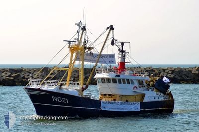
NG-21 MARIA-CHRIS
Fishing

Current Trip
| Time Travelled | 2 days |
|---|---|
| Remaining Time | --- |
| Distance Travelled | 212.93 nm |
| Remaining Distance | --- |
| AVG Speed | 4.6 Knopen |
| MAX Speed | 9.5 Knopen |
| AVG Wind | 16.4 knots |
| MAX Wind | 21.9 knots |
| MIN Temp | 0.2°C / 32.36°F |
| MAX Temp | 6.4°C / 43.52°F |
| Diepgang | 4.4 M |
| Positie ontvangen | 1 h, 52 m geleden |
Current Position
| Lengtegraad | --- |
|---|---|
| Breedtegraat | --- |
| Status | Engaged in Fishing |
| Snelheid | 3.5 Knopen |
| Koers | 54° |
| Gebied | North Sea |
| Station | T-AIS |
| Positie ontvangen | 1 h, 52 m geleden |
Information
The current position of NG-21 MARIA-CHRIS is in North Sea with coordinates 51.59125° / 2.27533° as reported on 2025-02-19 14:33 by AIS to our vessel tracker app. The vessel's current speed is 3.5 Knopen
The vessel NG-21 MARIA-CHRIS (IMO: 9013921, MMSI: 211680250) is a Fishing It's sailing under the flag of [DE] Germany.
In this page you can find informations about the vessels current position, last detected port calls, and current voyage information. If the vessels is not in coverage by AIS you will find the latest position.
The current position of NG-21 MARIA-CHRIS is detected by our AIS receivers and we are not responsible for the reliability of the data. The last position was recorded while the vessel was in Coverage by the Ais receivers of our vessel tracking app.
The current draught of NG-21 MARIA-CHRIS as reported by AIS is 4.4 meters
Weather
| Temperature | 6.2°C / 43.16°F |
|---|---|
| Wind Speed | 16 knots |
| Direction | 149° SSE |
| Pressure | 1017.6 hPa |
| Humidity | 63.3 % |
| Cloud Coverage | 100 % |


Featured Company
Last Port Calls
| Port | Arrival | Departure | Time In Port |
|---|---|---|---|
| 2025-02-16 20:04 | 2025-02-16 22:22 | 2 h | |
| 2025-02-06 23:06 | 2025-02-11 16:58 | 4 d | |
| 2025-02-02 23:54 | 2025-02-03 02:02 | 2 h | |
| 2025-01-23 16:23 | 2025-01-28 22:48 | 5 d | |
| 2025-01-19 21:20 | 2025-01-19 23:43 | 2 h | |
| 2025-01-16 21:02 | 2025-01-16 23:46 | 2 h | |
| 2025-01-10 00:32 | 2025-01-13 19:53 | 3 d | |
| 2025-01-05 00:41 | 2025-01-06 20:46 | 1 d | |
| 2024-12-21 05:54 | 2025-01-02 13:26 | 12 d | |
| 2024-12-17 23:18 | 2024-12-19 18:26 | 1 d |
Most Visited Ports (Last year)
| Port | Arrivals | |
|---|---|---|
| 22 | ||
| 4 | ||
| 3 | ||
| 3 | ||
| 3 | ||
| 1 |
Last Trips
| Origin | Departure | Destination | Arrival | Distance | |
|---|---|---|---|---|---|
| 2025-02-11 17:58 | 2025-02-16 21:04 | 203.11 nm | |||
| 2025-02-03 03:02 | 2025-02-07 00:06 | 171.32 nm | |||
| 2025-01-28 23:48 | 2025-02-03 00:54 | 419.82 nm | |||
| 2025-01-20 00:43 | 2025-01-23 17:23 | 288.30 nm | |||
| 2025-01-17 00:46 | 2025-01-19 22:20 | 258.06 nm | |||
| 2025-01-13 20:53 | 2025-01-16 22:02 | 292.93 nm | |||
| 2025-01-06 21:46 | 2025-01-10 01:32 | 302.72 nm | |||
| 2025-01-02 14:26 | 2025-01-05 01:41 | 273.72 nm | |||
| 2024-12-19 19:26 | 2024-12-21 06:54 | 214.47 nm | |||
| 2024-12-10 15:36 | 2024-12-18 00:18 | 633.10 nm |
Events
| Tijd | Evenement | Details | Positie / Bestemming | Info |
|---|---|---|---|---|
| 2025-02-19 14:33 | Buitenbereik |
51.59125 / 2.27533
North Sea
|
Snelheid: 3.5 kn Koers: 53.9° |
|
| 2025-02-19 14:06 | Wijzig zee gebeid | Belgian part of the North Sea United Kingdom part of the North Sea |
51.57489 / 2.24519
North Sea
|
Snelheid: 2.9 kn Koers: 43.2° |
| 2025-02-19 10:59 | Wijzig zee gebeid | United Kingdom part of the North Sea Belgian part of the North Sea |
51.54179 / 2.19093
North Sea
|
Snelheid: 3.9 kn Koers: 227.1° |
| 2025-02-19 10:59 | Binnenbereik |
51.54179 / 2.19093
North Sea
|
Snelheid: 3.9 kn Koers: 227.1° |
|
| 2025-02-19 09:49 | Buitenbereik |
51.59541 / 2.28369
North Sea
|
Snelheid: 3.8 kn Koers: 232.4° |
|
| 2025-02-19 08:07 | Wijzig zee gebeid | Belgian part of the North Sea United Kingdom part of the North Sea |
51.57532 / 2.24399
North Sea
|
Snelheid: 3.8 kn Koers: 53.5° |
| 2025-02-19 02:06 | Start beweging |
51.47216 / 2.08934
VLISSINGEN
|
Snelheid: 3.1 kn Koers: 196° |
|
| 2025-02-18 23:05 | Stop beweging |
51.46048 / 2.07517
VLISSINGEN
|
Snelheid: 0.3 kn Koers: 40° |
|
| 2025-02-18 20:53 | Gevonden in zee | United Kingdom part of the North Sea |
51.56722 / 2.21555
North Sea
|
Snelheid: 3.6 kn Koers: 208.6° |
| 2025-02-18 20:53 | Binnenbereik |
51.56722 / 2.21555
North Sea
|
Snelheid: 3.6 kn Koers: 208.6° |