
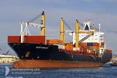
NEWYORKER
Container Ship
Current Trip
| Time Travelled | 2 days |
|---|---|
| Remaining Time | 5 days |
| Distance Travelled | 225.25 nm |
| Remaining Distance | 1442.39 nm |
| AVG Speed | 7.3 Knopen |
| MAX Speed | 17.5 Knopen |
| AVG Wind | 15.6 knots |
| MAX Wind | 24.9 knots |
| MIN Temp | 10.1°C / 50.18°F |
| MAX Temp | 17.5°C / 63.5°F |
| Diepgang | 12.5 M |
| Positie ontvangen | 3 h, 51 m geleden |
Current Position
| Lengtegraad | -6.07325° |
|---|---|
| Breedtegraat | 35.81630° |
| Status | Under way using engine |
| Snelheid | 10 Knopen |
| Koers | 218.1° |
| Gebied | North Atlantic Ocean |
| Station | T-AIS |
| Positie ontvangen | 3 h, 51 m geleden |
Info
Information
The current position of NEWYORKER is in North Atlantic Ocean with coordinates 35.81630° / -6.07325° as reported on 2024-04-28 07:15 by AIS to our vessel tracker app. The vessel's current speed is 10 Knopen and is heading at the port of DAKAR. The estimated time of arrival as calculated by MyShipTracking vessel tracking app is 2024-05-03 18:32 LT
The vessel NEWYORKER (IMO: 9209104, MMSI: 357411000) is a Container Ship that was built in 2001 ( 23 Jaar oud ). It's sailing under the flag of [PA] Panama.
In this page you can find informations about the vessels current position, last detected port calls, and current voyage information. If the vessels is not in coverage by AIS you will find the latest position.
The current position of NEWYORKER is detected by our AIS receivers and we are not responsible for the reliability of the data. The last position was recorded while the vessel was in Coverage by the Ais receivers of our vessel tracking app.
The current draught of NEWYORKER as reported by AIS is 12.5 meters
Weather
| Temperature | 15.9°C / 60.62°F |
|---|---|
| Wind Speed | 8 knots |
| Direction | 340° NNW |
| Pressure | 1014.5 hPa |
| Humidity | 63.9 % |
| Cloud Coverage | 9 % |
Featured Company
Last Port Calls
| Port | Arrival | Departure | Time In Port |
|---|---|---|---|
| 2024-04-25 07:36 | 2024-04-25 21:31 | 13 h | |
| 2024-04-23 12:09 | 2024-04-24 08:29 | 20 h | |
| 2024-04-19 15:31 | 2024-04-21 14:21 | 1 d | |
| 2024-04-16 17:29 | 2024-04-17 15:08 | 21 h | |
| 2024-04-10 13:12 | 2024-04-11 04:28 | 15 h | |
| 2024-04-09 01:12 | 2024-04-10 00:42 | 23 h | |
| 2024-04-04 02:26 | 2024-04-04 15:57 | 13 h | |
| 2024-04-01 19:47 | 2024-04-02 08:57 | 13 h | |
| 2024-03-27 23:53 | 2024-03-28 16:21 | 16 h | |
| 2024-03-24 04:19 | 2024-03-24 13:22 | 9 h |
Last Trips
| Origin | Departure | Destination | Arrival | Distance | |
|---|---|---|---|---|---|
| 2024-04-24 10:29 | 2024-04-25 08:36 | 84.04 nm | |||
| 2024-04-21 15:21 | 2024-04-23 14:09 | 278.96 nm | |||
| 2024-04-17 17:08 | 2024-04-19 16:31 | 204.69 nm | |||
| 2024-04-10 02:42 | 2024-04-16 19:29 | 2116.96 nm | |||
| 2024-04-10 02:42 | 2024-04-10 15:12 | 169.44 nm | |||
| 2024-04-04 17:57 | 2024-04-09 03:12 | 1821.91 nm | |||
| 2024-04-02 10:57 | 2024-04-04 04:26 | 10.46 nm | |||
| 2024-03-28 17:21 | 2024-04-01 21:47 | 1079.09 nm | |||
| 2024-03-22 12:11 | 2024-03-28 00:53 | 1305.63 nm | |||
| 2024-03-22 12:11 | 2024-03-24 06:19 | 271.85 nm |
Events
| Tijd | Evenement | Details | Positie / Bestemming | Info |
|---|---|---|---|---|
| 2024-04-28 07:20 | Status Changed | Default Under way using engine |
35.80500 / -6.08167
DAKAR
|
Snelheid: 10 kn Koers: 218.1° |
| 2024-04-28 07:15 | Buitenbereik |
35.81630 / -6.07325
North Atlantic Ocean
DAKAR
|
Snelheid: 10 kn Koers: 218.1° |
|
| 2024-04-28 06:44 | Status Changed | Under way using engine Default |
35.89586 / -6.00746
DAKAR
|
Snelheid: 9.9 kn Koers: 212° |
| 2024-04-28 06:41 | Status Changed | Default Under way using engine |
35.89666 / -6.00687
DAKAR
|
Snelheid: 9.5 kn Koers: 213.6° |
| 2024-04-28 06:37 | Status Changed | Under way using engine Default |
35.90736 / -5.99840
DAKAR
|
Snelheid: 9.5 kn Koers: 213° |
| 2024-04-28 06:34 | Status Changed | Default Under way using engine |
35.91325 / -5.99362
DAKAR
|
Snelheid: 8.7 kn Koers: 230.3° |
| 2024-04-28 06:25 | Wijzig zee gebeid | Moroccan part of the North Atlantic Ocean Moroccan part of the Strait of Gibraltar |
35.92634 / -5.97495
North Atlantic Ocean
DAKAR
|
Snelheid: 9.1 kn Koers: 254.4° |
| 2024-04-28 06:23 | Status Changed | Under way using engine Default |
35.92804 / -5.96623
DAKAR
|
Snelheid: 9.1 kn Koers: 257° |
| 2024-04-28 06:22 | Status Changed | Default Under way using engine |
35.92833 / -5.96472
DAKAR
|
Snelheid: 9.3 kn Koers: 254.4° |
| 2024-04-28 06:16 | Status Changed | Under way using engine Default |
35.93236 / -5.94647
DAKAR
|
Snelheid: 9.2 kn Koers: 256° |