
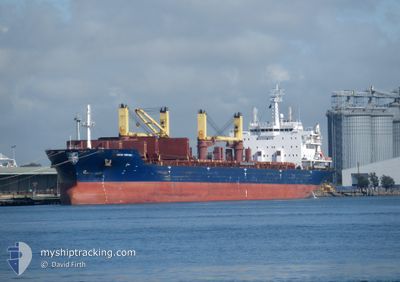
NAVIS FORTUNA
Bulk Carrier
Current Trip
| Time Travelled | 53 days |
|---|---|
| Remaining Time | 2 days |
| Distance Travelled | 11557.78 nm |
| Remaining Distance | 797.56 nm |
| AVG Speed | 10.5 Knopen |
| MAX Speed | 14.9 Knopen |
| AVG Wind | 12.7 knots |
| MAX Wind | 29 knots |
| MIN Temp | 10.9°C / 51.62°F |
| MAX Temp | 28.3°C / 82.94°F |
| Diepgang | 10.5 M |
| Positie ontvangen | 4 d geleden |
Current Position
| Lengtegraad | --- |
|---|---|
| Breedtegraat | --- |
| Status | Under way using engine |
| Snelheid | 13.3 Knopen |
| Koers | 80.9° |
| Gebied | Alboran Sea |
| Station | T-AIS |
| Positie ontvangen | 4 d geleden |
Info
Information
The current position of NAVIS FORTUNA is in Alboran Sea with coordinates 36.11102° / -4.67520° as reported on 2025-01-13 07:26 by AIS to our vessel tracker app. The vessel's current speed is 13.3 Knopen and is heading at the port of DAMIETTA. The estimated time of arrival as calculated by MyShipTracking vessel tracking app is 2025-01-20 08:30 LT
The vessel NAVIS FORTUNA (IMO: 9404455, MMSI: 538009155) is a Bulk Carrier that was built in 2010 ( 15 Jaar oud ). It's sailing under the flag of [MH] Marshall Is.
In this page you can find informations about the vessels current position, last detected port calls, and current voyage information. If the vessels is not in coverage by AIS you will find the latest position.
The current position of NAVIS FORTUNA is detected by our AIS receivers and we are not responsible for the reliability of the data. The last position was recorded while the vessel was in Coverage by the Ais receivers of our vessel tracking app.
The current draught of NAVIS FORTUNA as reported by AIS is 10.5 meters
Weather
| Temperature | 17°C / 62.6°F |
|---|---|
| Wind Speed | 22 knots |
| Direction | 153° SSE |
| Pressure | 1021.3 hPa |
| Humidity | 82.9 % |
| Cloud Coverage | 6 % |
Featured Company
Last Port Calls
| Port | Arrival | Departure | Time In Port |
|---|---|---|---|
| 2024-11-24 06:38 | 2024-11-25 07:39 | 1 d | |
| 2024-11-12 14:51 | 2024-11-21 21:07 | 9 d | |
| 2024-11-05 07:27 |
Most Visited Ports (Last year)
| Port | Arrivals | |
|---|---|---|
| 2 | ||
| 2 | ||
| 2 | ||
| 2 | ||
| 1 | ||
| 1 |
Last Trips
| Origin | Departure | Destination | Arrival | Distance | |
|---|---|---|---|---|---|
| 2024-11-22 08:07 | 2024-11-24 17:38 | 165.33 nm | |||
| 2024-11-05 20:27 | 2024-11-13 01:51 | 1397.25 nm |
Events
| Tijd | Evenement | Details | Positie / Bestemming | Info |
|---|---|---|---|---|
| 2025-01-13 07:31 | Status Changed | Default Under way using engine |
36.11379 / -4.65327
EGDAM
|
Snelheid: 13.3 kn Koers: 80.9° |
| 2025-01-13 07:26 | Status Changed | Under way using engine Default |
36.11102 / -4.67520
EGDAM
|
Snelheid: 13.3 kn Koers: 80° |
| 2025-01-13 07:26 | Buitenbereik |
36.11102 / -4.67520
Alboran Sea
EGDAM
|
Snelheid: 13.3 kn Koers: 80.9° |
|
| 2025-01-13 07:19 | Status Changed | Default Under way using engine |
36.10600 / -4.71143
EGDAM
|
Snelheid: 13.3 kn Koers: 80° |
| 2025-01-13 06:35 | Wijzig zee gebeid | Spanish part of the Alboran Sea Gibraltarian part of the Alboran Sea |
36.08936 / -4.90418
Alboran Sea
EGDAM
|
Snelheid: 12.7 kn Koers: 91.1° |
| 2025-01-13 04:59 | Wijzig zee gebeid | Gibraltarian part of the Alboran Sea Gibraltarian part of the Strait of Gibraltar |
36.06704 / -5.32206
Alboran Sea
EGDAM
|
Snelheid: 13 kn Koers: 92.1° |
| 2025-01-13 04:50 | Wijzig zee gebeid | Gibraltarian part of the Strait of Gibraltar Spanish part of the Strait of Gibraltar |
36.06779 / -5.35922
Strait of Gibraltar
EGDAM
|
Snelheid: 10.5 kn Koers: 90.1° |
| 2025-01-13 04:22 | Start beweging | 2.04 nm, South of ALGECIRAS |
36.10298 / -5.41343
EGDAM
|
Snelheid: 3.1 kn Koers: 108° |
| 2025-01-13 04:16 | Status Changed | Under way using engine At anchor |
36.10047 / -5.41578
EGDAM
|
Snelheid: 1.6 kn Koers: 350° |
| 2025-01-13 03:38 | Status Changed | At anchor Under way using engine |
36.10291 / -5.41039
EGDAM
|
Snelheid: 0.3 kn Koers: 249° |