

NATALIE
General Cargo

Current Trip
| Time Travelled | 2 days |
|---|---|
| Remaining Time | 16 h, 38 mins |
| Distance Travelled | 500.13 nm |
| Remaining Distance | 115.83 nm |
| AVG Speed | 9.4 Knopen |
| MAX Speed | 12.4 Knopen |
| AVG Wind | 5.8 knots |
| MAX Wind | 13 knots |
| MIN Temp | 5.6°C / 42.08°F |
| MAX Temp | 11.2°C / 52.16°F |
| Diepgang | 5.7 M |
| Positie ontvangen | 1 m geleden |
Current Position
| Lengtegraad | --- |
|---|---|
| Breedtegraat | --- |
| Status | Not under command |
| Snelheid | 5.4 Knopen |
| Koers | 69° |
| Gebied | North Sea |
| Station | T-AIS |
| Positie ontvangen | 1 m geleden |
Information
The current position of NATALIE is in North Sea with coordinates 51.04779° / 1.79106° as reported on 2025-03-27 13:21 by AIS to our vessel tracker app. The vessel's current speed is 5.4 Knopen and is heading at the port of ROTTERDAM. The estimated time of arrival as calculated by MyShipTracking vessel tracking app is 2025-03-28 07:01 LT
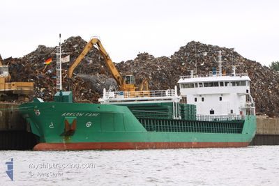
The vessel NATALIE (IMO: 9361720, MMSI: 304428000) is a General Cargo that was built in 2006 ( 19 Jaar oud ). It's sailing under the flag of [AG] Antigua Barbuda.
In this page you can find informations about the vessels current position, last detected port calls, and current voyage information. If the vessels is not in coverage by AIS you will find the latest position.
The current position of NATALIE is detected by our AIS receivers and we are not responsible for the reliability of the data. The last position was recorded while the vessel was in Coverage by the Ais receivers of our vessel tracking app.
The current draught of NATALIE as reported by AIS is 5.7 meters
Weather
| Temperature | 8.9°C / 48.02°F |
|---|---|
| Wind Speed | 8 knots |
| Direction | 247° WSW |
| Pressure | 1020.7 hPa |
| Humidity | 81.7 % |
| Cloud Coverage | 6 % |


Featured Company
Last Port Calls
| Port | Arrival | Departure | Time In Port |
|---|---|---|---|
| 2025-03-22 10:51 | 2025-03-25 01:47 | 2 d | |
| 2025-03-18 07:38 | 2025-03-19 19:20 | 1 d | |
| 2025-03-17 02:07 | 2025-03-18 06:53 | 1 d | |
| 2025-03-14 14:16 | 2025-03-15 15:54 | 1 d | |
| 2025-03-12 14:39 | 2025-03-13 21:10 | 1 d | |
| 2025-03-09 20:14 | 2025-03-10 14:57 | 18 h | |
| 2025-03-07 05:21 | 2025-03-08 12:36 | 1 d | |
| 2025-02-27 18:51 | 2025-03-03 20:21 | 4 d | |
| 2025-02-23 17:43 | 2025-02-24 21:12 | 1 d | |
| 2025-02-17 00:29 | 2025-02-21 09:23 | 4 d |
Last Trips
| Origin | Departure | Destination | Arrival | Distance | |
|---|---|---|---|---|---|
| 2025-03-19 19:20 | 2025-03-22 10:51 | 616.32 nm | |||
| 2025-03-18 06:53 | 2025-03-18 07:38 | 7.27 nm | |||
| 2025-03-15 15:54 | 2025-03-17 02:07 | 172.51 nm | |||
| 2025-03-13 21:10 | 2025-03-14 14:16 | 185.55 nm | |||
| 2025-03-10 14:57 | 2025-03-12 14:39 | 174.24 nm | |||
| 2025-03-08 12:36 | 2025-03-09 20:14 | 334.19 nm | |||
| 2025-03-03 20:21 | 2025-03-07 05:21 | 782.24 nm | |||
| 2025-02-24 21:12 | 2025-02-27 18:51 | 616.98 nm | |||
| 2025-02-21 09:23 | 2025-02-23 17:43 | 6.31 nm | |||
| 2025-02-13 14:38 | 2025-02-17 00:29 | 811.48 nm |
Events
| Tijd | Evenement | Details | Positie / Bestemming | Info |
|---|---|---|---|---|
| 2025-03-27 12:22 | Wijzig zee gebeid | French part of the North Sea French part of the English Channel |
50.99200 / 1.64100
North Sea
NLRTM
|
Snelheid: 7.4 kn Koers: 65° |
| 2025-03-27 10:55 | Status Changed | Not under command Default |
50.91174 / 1.47320
NLRTM
|
Snelheid: 3.4 kn Koers: 295° |
| 2025-03-27 10:50 | Status Changed | Default Not under command |
50.90700 / 1.46933
NLRTM
|
Snelheid: 3.5 kn Koers: 307° |
| 2025-03-27 10:43 | Status Changed | Not under command Default |
50.90067 / 1.46433
NLRTM
|
Snelheid: 3.5 kn Koers: 307° |
| 2025-03-27 10:42 | Status Changed | Default Not under command |
50.89995 / 1.46377
NLRTM
|
Snelheid: 3.5 kn Koers: 307° |
| 2025-03-27 10:19 | Status Changed | Not under command Default |
50.88041 / 1.45054
NLRTM
|
Snelheid: 3.3 kn Koers: 295° |
| 2025-03-27 10:14 | Status Changed | Default Not under command |
50.87571 / 1.44781
NLRTM
|
Snelheid: 3.4 kn Koers: 293° |
| 2025-03-27 10:05 | Status Changed | Not under command Default |
50.86786 / 1.44347
NLRTM
|
Snelheid: 3.2 kn Koers: 289° |
| 2025-03-27 09:58 | Status Changed | Default Not under command |
50.86183 / 1.44050
NLRTM
|
Snelheid: 3.1 kn Koers: 270° |
| 2025-03-27 09:52 | Start beweging | 9.75 nm, North West of BOULOGNE-SUR-MER |
50.85696 / 1.43820
NLRTM
|
Snelheid: 3.1 kn Koers: 270° |