

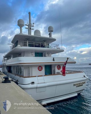
MY MARIDOME
Yacht

Current Trip
| Trip Time | 18 h, 30 mins |
|---|---|
| Trip Distance | 194.08 nm |
| AVG Speed | 9.5 Knopen |
| MAX Speed | 11.8 Knopen |
| Diepgang | 3.8 M |
| AVG Wind | 5.9 knots |
| MAX Wind | 20 knots |
| MIN Temp | 19.6°C / 67.28°F |
| MAX Temp | 23.5°C / 74.3°F |
| Positie ontvangen | 2 m geleden |
Current Position
| Lengtegraad | --- |
|---|---|
| Breedtegraat | --- |
| Status | Moored |
| Snelheid | 0.1 Knopen |
| Koers | 42° |
| Gebied | Balearic Sea |
| Station | T-AIS |
| Positie ontvangen | 2 m geleden |
Information
The current position of MY MARIDOME is in Balearic Sea with coordinates 41.52841° / 2.44455° as reported on 2025-03-29 17:03 by AIS to our vessel tracker app. The vessel's current speed is 0.1 Knopen and is currently inside the port of MATARO.
The vessel MY MARIDOME (IMO: 1002641, MMSI: 235241000) is a Yacht that was built in 1989 ( 36 Jaar oud ). It's sailing under the flag of [GB] United Kingdom.
In this page you can find informations about the vessels current position, last detected port calls, and current voyage information. If the vessels is not in coverage by AIS you will find the latest position.
The current position of MY MARIDOME is detected by our AIS receivers and we are not responsible for the reliability of the data. The last position was recorded while the vessel was in Coverage by the Ais receivers of our vessel tracking app.
The current draught of MY MARIDOME as reported by AIS is 3.8 meters
Weather
| Temperature | 15.4°C / 59.72°F |
|---|---|
| Wind Speed | 9 knots |
| Direction | 168° SSE |
| Pressure | 1010.6 hPa |
| Humidity | 44.6 % |
| Cloud Coverage | 31 % |


Featured Company
Last Port Calls
Most Visited Ports (Last year)
| Port | Arrivals | |
|---|---|---|
| 3 | ||
| 2 | ||
| 1 | ||
| 1 | ||
| 1 | ||
| 1 |
Last Trips
| Origin | Departure | Destination | Arrival | Distance |
|---|
Events
| Tijd | Evenement | Details | Positie / Bestemming | Info |
|---|---|---|---|---|
| 2025-03-28 14:05 | Binnenbereik |
41.52846 / 2.44457
Balearic Sea
[ES] MATARO
|
Snelheid: 0.1 kn Koers: 326.7° |
|
| 2025-03-28 12:47 | Buitenbereik |
41.52848 / 2.44456
Balearic Sea
[ES] MATARO
|
Snelheid: 0.1 kn Koers: 292.9° |
|
| 2025-03-28 10:44 | Binnenbereik |
41.52843 / 2.44455
Balearic Sea
[ES] MATARO
|
Snelheid: 0.1 kn Koers: 233.2° |
|
| 2025-03-28 09:35 | Buitenbereik |
41.52842 / 2.44450
Balearic Sea
[ES] MATARO
|
Snelheid: 0.1 kn Koers: 248.4° |
|
| 2025-03-27 14:10 | Binnenbereik |
41.52845 / 2.44455
Balearic Sea
[ES] MATARO
|
Snelheid: 0.1 kn Koers: 309° |
|
| 2025-03-27 13:16 | Binnenbereik |
41.52847 / 2.44460
Balearic Sea
[ES] MATARO
|
Snelheid: Koers: 303° |
|
| 2025-03-27 13:16 | Buitenbereik |
41.52847 / 2.44460
Balearic Sea
[ES] MATARO
|
Snelheid: Koers: 303° |
|
| 2025-03-27 11:52 | Buitenbereik |
41.52847 / 2.44453
Balearic Sea
[ES] MATARO
|
Snelheid: Koers: 241.1° |
|
| 2025-03-25 18:33 | Binnenbereik |
41.52846 / 2.44458
Balearic Sea
[ES] MATARO
|
Snelheid: 0.1 kn Koers: 329.3° |
|
| 2025-03-25 16:39 | Buitenbereik |
41.52843 / 2.44461
Balearic Sea
[ES] MATARO
|
Snelheid: 0.1 kn Koers: 263.7° |