
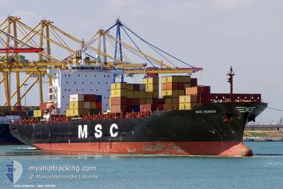
MSC DONATA
Container Ship
Current Trip
| Time Travelled | 1 day |
|---|---|
| Remaining Time | 2 h, 41 mins |
| Distance Travelled | 128.77 nm |
| Remaining Distance | 37.00 nm |
| AVG Speed | 11.8 Knopen |
| MAX Speed | 18.2 Knopen |
| AVG Wind | 10.8 knots |
| MAX Wind | 14 knots |
| MIN Temp | 6.5°C / 43.7°F |
| MAX Temp | 9.7°C / 49.46°F |
| Diepgang | 9.7 M |
| Positie ontvangen | 2 m geleden |
Current Position
| Lengtegraad | --- |
|---|---|
| Breedtegraat | --- |
| Status | Under way using engine |
| Snelheid | 0.8 Knopen |
| Koers | 276° |
| Gebied | North Sea |
| Station | T-AIS |
| Positie ontvangen | 2 m geleden |
Info
Information
The current position of MSC DONATA is in North Sea with coordinates 51.84142° / 3.19532° as reported on 2025-03-06 23:58 by AIS to our vessel tracker app. The vessel's current speed is 0.8 Knopen and is heading at the port of ROTTERDAM. The estimated time of arrival as calculated by MyShipTracking vessel tracking app is 2025-03-07 02:41 LT
The vessel MSC DONATA (IMO: 9237151, MMSI: 372491000) is a Container Ship that was built in 2002 ( 23 Jaar oud ). It's sailing under the flag of [PA] Panama.
In this page you can find informations about the vessels current position, last detected port calls, and current voyage information. If the vessels is not in coverage by AIS you will find the latest position.
The current position of MSC DONATA is detected by our AIS receivers and we are not responsible for the reliability of the data. The last position was recorded while the vessel was in Coverage by the Ais receivers of our vessel tracking app.
The current draught of MSC DONATA as reported by AIS is 9.7 meters
Weather
| Temperature | 8.3°C / 46.94°F |
|---|---|
| Wind Speed | 13 knots |
| Direction | 190° S |
| Pressure | 1015 hPa |
| Humidity | 77.3 % |
| Cloud Coverage | 51 % |
Featured Company
Last Port Calls
| Port | Arrival | Departure | Time In Port |
|---|---|---|---|
| 2025-03-05 06:09 | 2025-03-05 22:56 | 16 h | |
| 2025-03-03 16:00 | 2025-03-04 18:19 | 1 d | |
| 2025-02-13 23:17 | 2025-02-19 17:15 | 5 d | |
| 2025-02-02 13:40 | 2025-02-03 16:47 | 1 d | |
| 2025-01-30 03:00 | 2025-01-31 22:32 | 1 d | |
| 2025-01-24 14:55 | 2025-01-24 23:54 | 8 h | |
| 2025-01-19 05:59 | 2025-01-19 20:10 | 14 h | |
| 2025-01-13 23:00 | 2025-01-15 11:30 | 1 d | |
| 2025-01-09 18:04 | 2025-01-10 07:52 | 13 h | |
| 2025-01-04 11:48 | 2025-01-05 01:38 | 13 h |
Most Visited Ports (Last year)
| Port | Arrivals | |
|---|---|---|
| 8 | ||
| 6 | ||
| 5 | ||
| 5 | ||
| 4 | ||
| 4 |
Last Trips
| Origin | Departure | Destination | Arrival | Distance | |
|---|---|---|---|---|---|
| 2025-03-04 18:19 | 2025-03-05 07:09 | 182.89 nm | |||
| 2025-02-19 12:15 | 2025-03-03 16:00 | 3709.70 nm | |||
| 2025-02-03 17:47 | 2025-02-13 18:17 | 3191.34 nm | |||
| 2025-01-31 23:32 | 2025-02-02 14:40 | 353.58 nm | |||
| 2025-01-25 00:54 | 2025-01-30 04:00 | 556.17 nm | |||
| 2025-01-19 20:10 | 2025-01-24 15:55 | 360.80 nm | |||
| 2025-01-15 11:30 | 2025-01-19 05:59 | 811.03 nm | |||
| 2025-01-10 07:52 | 2025-01-13 23:00 | 1056.53 nm | |||
| 2025-01-05 03:38 | 2025-01-09 18:04 | 1783.24 nm | |||
| 2025-01-03 17:46 | 2025-01-04 13:48 | 274.77 nm |
Events
| Tijd | Evenement | Details | Positie / Bestemming | Info |
|---|---|---|---|---|
| 2025-03-06 22:13 | Stop beweging | 21.4 nm, North West of NEELTJE JANS |
51.82444 / 3.22498
NLRTM
|
Snelheid: 0.3 kn Koers: 185° |
| 2025-03-06 22:06 | Status Changed | Under way using engine Default |
51.82580 / 3.22518
NLRTM
|
Snelheid: 1.7 kn Koers: 175° |
| 2025-03-06 22:05 | Status Changed | Default Under way using engine |
51.82663 / 3.22496
NLRTM
|
Snelheid: 3.7 kn Koers: 169° |
| 2025-03-06 21:55 | Status Changed | Under way using engine Default |
51.83479 / 3.22196
NLRTM
|
Snelheid: 8.8 kn Koers: 168° |
| 2025-03-06 21:51 | Status Changed | Default Under way using engine |
51.84236 / 3.21932
NLRTM
|
Snelheid: 8.4 kn Koers: 167.5° |
| 2025-03-06 21:47 | Status Changed | Under way using engine Default |
51.85106 / 3.21623
NLRTM
|
Snelheid: 3.1 kn Koers: 193° |
| 2025-03-06 21:38 | Status Changed | Default Under way using engine |
51.86554 / 3.21206
NLRTM
|
Snelheid: 3.3 kn Koers: 211° |
| 2025-03-06 19:30 | Status Changed | Under way using engine Default |
51.84056 / 3.21943
NLRTM
|
Snelheid: 8.4 kn Koers: 169° |
| 2025-03-06 19:13 | Status Changed | Default Under way using engine |
51.87314 / 3.19643
NLRTM
|
Snelheid: 7.6 kn Koers: 21.8° |
| 2025-03-06 17:01 | Binnenbereik |
51.84903 / 3.27982
North Sea
NLRTM
|
Snelheid: 5.8 kn Koers: 38.2° |