
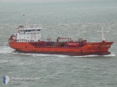
MRC HATICE ANA
Oil/Chemical Tanker
Current Trip
| Time Travelled | 3 days |
|---|---|
| Remaining Time | 1 day |
| Distance Travelled | 420.18 nm |
| Remaining Distance | 492.19 nm |
| AVG Speed | 9.7 Knopen |
| MAX Speed | 12.2 Knopen |
| AVG Wind | 8.3 knots |
| MAX Wind | 27.5 knots |
| MIN Temp | 1.9°C / 35.42°F |
| MAX Temp | 13°C / 55.4°F |
| Diepgang | 5 M |
| Positie ontvangen | 1 m geleden |
Current Position
| Lengtegraad | --- |
|---|---|
| Breedtegraat | --- |
| Status | Under way using engine |
| Snelheid | 10.9 Knopen |
| Koers | 127° |
| Gebied | Adriatic Sea |
| Station | T-AIS |
| Positie ontvangen | 1 m geleden |
Info
Information
The current position of MRC HATICE ANA is in Adriatic Sea with coordinates 42.13197° / 16.18938° as reported on 2025-02-07 17:21 by AIS to our vessel tracker app. The vessel's current speed is 10.9 Knopen and is heading at the port of VALLETTA. The estimated time of arrival as calculated by MyShipTracking vessel tracking app is 2025-02-09 15:06 LT
The vessel MRC HATICE ANA (IMO: 9536935, MMSI: 215345000) is a Oil/Chemical Tanker that was built in 2011 ( 14 Jaar oud ). It's sailing under the flag of [MT] Malta.
In this page you can find informations about the vessels current position, last detected port calls, and current voyage information. If the vessels is not in coverage by AIS you will find the latest position.
The current position of MRC HATICE ANA is detected by our AIS receivers and we are not responsible for the reliability of the data. The last position was recorded while the vessel was in Coverage by the Ais receivers of our vessel tracking app.
The current draught of MRC HATICE ANA as reported by AIS is 5 meters
Weather
| Temperature | 12.9°C / 55.22°F |
|---|---|
| Wind Speed | 9 knots |
| Direction | 124° SE |
| Pressure | 1028.4 hPa |
| Humidity | 70 % |
| Cloud Coverage | 100 % |
Featured Company
Last Port Calls
| Port | Arrival | Departure | Time In Port |
|---|---|---|---|
| 2025-02-03 17:33 | 2025-02-04 17:18 | 23 h | |
| 2025-01-26 16:00 | 2025-01-28 05:53 | 1 d | |
| 2025-01-24 21:11 | 2025-01-26 01:06 | 1 d | |
| 2025-01-13 23:31 | 2025-01-15 12:27 | 1 d | |
| 2025-01-10 09:28 | 2025-01-12 17:18 | 2 d | |
| 2025-01-07 15:21 | 2025-01-08 23:25 | 1 d | |
| 2024-12-31 09:46 | 2025-01-02 15:06 | 2 d | |
| 2024-12-27 02:56 | 2024-12-28 06:40 | 1 d | |
| 2024-12-25 15:25 | 2024-12-27 00:49 | 1 d | |
| 2024-12-24 22:30 | 2024-12-25 13:07 | 14 h |
Most Visited Ports (Last year)
| Port | Arrivals | |
|---|---|---|
| 4 | ||
| 3 | ||
| 3 | ||
| 3 | ||
| 2 | ||
| 2 |
Last Trips
| Origin | Departure | Destination | Arrival | Distance | |
|---|---|---|---|---|---|
| 2025-01-28 06:53 | 2025-02-03 18:33 | 773.92 nm | |||
| 2025-01-26 02:06 | 2025-01-26 17:00 | 154.83 nm | |||
| 2025-01-15 13:27 | 2025-01-24 22:11 | 2308.94 nm | |||
| 2025-01-12 18:18 | 2025-01-14 00:31 | 134.85 nm | |||
| 2025-01-09 00:25 | 2025-01-10 10:28 | 139.14 nm | |||
| 2025-01-02 16:06 | 2025-01-07 16:21 | 749.11 nm | |||
| 2024-12-28 07:40 | 2024-12-31 10:46 | 804.38 nm | |||
| 2024-12-27 01:49 | 2024-12-27 03:56 | 15.10 nm | |||
| 2024-12-25 14:07 | 2024-12-25 16:25 | 24.13 nm | |||
| 2024-12-23 20:24 | 2024-12-24 23:30 | 161.99 nm |
Events
| Tijd | Evenement | Details | Positie / Bestemming | Info |
|---|---|---|---|---|
| 2025-02-07 14:25 | Gevonden in zee | Italian part of the Adriatic Sea |
42.50733 / 15.69310
Adriatic Sea
MTMLA
|
Snelheid: 10.7 kn Koers: 140° |
| 2025-02-07 11:33 | Status Changed | Under way using engine Default |
42.90618 / 15.24635
MTMLA
|
Snelheid: 11 kn Koers: 142° |
| 2025-02-07 11:33 | Binnenbereik |
42.90348 / 15.24922
Adriatic Sea
MTMLA
|
Snelheid: 10.7 kn Koers: 142° |
|
| 2025-02-07 03:56 | Buitenbereik |
44.02613 / 14.11528
Adriatic Sea
MTMLA
|
Snelheid: 10.5 kn Koers: 134° |
|
| 2025-02-07 03:56 | Binnenbereik |
44.02613 / 14.11528
Adriatic Sea
MTMLA
|
Snelheid: 10.5 kn Koers: 134° |
|
| 2025-02-07 02:22 | Buitenbereik |
44.24943 / 13.88158
Adriatic Sea
MTMLA
|
Snelheid: 10.7 kn Koers: 145° |
|
| 2025-02-06 19:41 | Wijzig zee gebeid | Croatian part of the Adriatic Sea Italian part of the Adriatic Sea |
45.23850 / 13.04652
Adriatic Sea
MTMLA
|
Snelheid: 10.3 kn Koers: 167° |
| 2025-02-06 16:54 | ETA Changed | 2025/02/09 16:00 |
45.60002 / 13.46723
MTMLA
|
Snelheid: 11 kn Koers: 249° |
| 2025-02-06 16:43 | Wijzig zee gebeid | Italian part of the Adriatic Sea Slovenian part of the Adriatic Sea |
45.61122 / 13.50985
Adriatic Sea
MTMLA
|
Snelheid: 10.9 kn Koers: 249° |
| 2025-02-06 16:05 | Wijzig zee gebeid | Slovenian part of the Adriatic Sea Italian part of the Adriatic Sea |
45.61800 / 13.67102
Adriatic Sea
MTMLA
|
Snelheid: 11.3 kn Koers: 271° |