

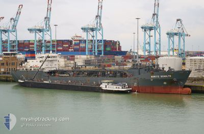
MORITZ SCHULTE
Lpg Tanker

Current Trip
SINES
| Time Travelled | 5 days |
|---|---|
| Remaining Time | --- |
| Distance Travelled | 9.99 nm |
| Remaining Distance | --- |
| AVG Speed | 6.7 Knopen |
| MAX Speed | 11.1 Knopen |
| AVG Wind | 5.8 knots |
| MAX Wind | 12.7 knots |
| MIN Temp | 6.6°C / 43.88°F |
| MAX Temp | 17.9°C / 64.22°F |
| Diepgang | 5.7 M |
| Positie ontvangen | 3 m geleden |
Current Position
| Lengtegraad | --- |
|---|---|
| Breedtegraat | --- |
| Status | At anchor |
| Snelheid | 0.3 Knopen |
| Koers | 127° |
| Gebied | North Atlantic Ocean |
| Station | T-AIS |
| Positie ontvangen | 3 m geleden |
Information
The current position of MORITZ SCHULTE is in North Atlantic Ocean with coordinates 37.88077° / -8.86714° as reported on 2025-02-28 13:33 by AIS to our vessel tracker app. The vessel's current speed is 0.3 Knopen
The vessel MORITZ SCHULTE (IMO: 9220794, MMSI: 235307000) is a Lpg Tanker that was built in 2002 ( 23 Jaar oud ). It's sailing under the flag of [GB] United Kingdom.
In this page you can find informations about the vessels current position, last detected port calls, and current voyage information. If the vessels is not in coverage by AIS you will find the latest position.
The current position of MORITZ SCHULTE is detected by our AIS receivers and we are not responsible for the reliability of the data. The last position was recorded while the vessel was in Coverage by the Ais receivers of our vessel tracking app.
The current draught of MORITZ SCHULTE as reported by AIS is 5.7 meters
Weather
| Temperature | 12.1°C / 53.78°F |
|---|---|
| Wind Speed | 9 knots |
| Direction | 72° ENE |
| Pressure | 1011.6 hPa |
| Humidity | 89.1 % |
| Cloud Coverage | 100 % |


Featured Company
Last Port Calls
| Port | Arrival | Departure | Time In Port |
|---|---|---|---|
| 2025-02-23 06:57 | 2025-02-23 11:05 | 4 h | |
| 2025-02-17 16:51 | 2025-02-18 10:59 | 18 h | |
| 2025-01-20 23:32 | 2025-01-21 08:32 | 9 h | |
| 2025-01-12 04:50 | 2025-01-12 14:05 | 9 h | |
| 2025-01-08 13:58 | 2025-01-09 15:14 | 1 d | |
| 2024-12-26 09:06 | 2024-12-27 23:19 | 1 d | |
| 2024-12-24 04:52 | 2024-12-24 14:00 | 9 h | |
| 2024-12-09 22:44 | 2024-12-12 19:01 | 2 d | |
| 2024-12-08 17:56 | 2024-12-09 18:26 | 1 d |
Most Visited Ports (Last year)
| Port | Arrivals | |
|---|---|---|
| 11 | ||
| 11 | ||
| 5 | ||
| 3 | ||
| 2 | ||
| 2 |
Last Trips
| Origin | Departure | Destination | Arrival | Distance | |
|---|---|---|---|---|---|
| 2025-02-18 10:59 | 2025-02-23 06:57 | 9.77 nm | |||
| 2025-01-21 09:32 | 2025-02-17 16:51 | 1265.62 nm | |||
| 2025-01-09 18:14 | 2025-01-21 00:32 | 2687.03 nm | |||
| 2025-01-09 18:14 | 2025-01-12 06:50 | 580.69 nm | |||
| 2024-12-28 02:19 | 2025-01-08 16:58 | 679.31 nm | |||
| 2024-12-12 20:01 | 2024-12-26 12:06 | 3973.31 nm | |||
| 2024-12-12 20:01 | 2024-12-24 06:52 | 3377.11 nm | |||
| 2024-12-09 19:26 | 2024-12-09 23:44 | 52.71 nm | |||
| 2024-11-29 15:29 | 2024-12-08 18:56 | 1613.09 nm |
Events
| Tijd | Evenement | Details | Positie / Bestemming | Info |
|---|---|---|---|---|
| 2025-02-27 14:48 | Status Changed | At anchor Default |
37.88201 / -8.86370
SINES
|
Snelheid: 0.5 kn Koers: 182° |
| 2025-02-27 14:45 | Status Changed | Default At anchor |
37.88213 / -8.86406
SINES
|
Snelheid: 0.2 kn Koers: 191° |
| 2025-02-23 11:45 | Stop beweging | 3.94 nm, South of SINES |
37.87821 / -8.86332
SINES
|
Snelheid: 0.3 kn Koers: 324° |
| 2025-02-23 11:30 | Status Changed | At anchor Under way using engine |
37.87930 / -8.86471
SINES
|
Snelheid: 1.3 kn Koers: 342° |
| 2025-02-23 11:05 | Vertrekhaven |
|
37.92858 / -8.87026
SINES
|
Snelheid: 11.5 kn Koers: 153° |
| 2025-02-23 10:55 | Start beweging |
37.94637 / -8.88290
[PT] SINES
|
Snelheid: 3.5 kn Koers: 151° |
|
| 2025-02-23 10:50 | Status Changed | Under way using engine Moored |
37.94833 / -8.88334
[PT] SINES
|
Snelheid: 0.1 kn Koers: 177° |
| 2025-02-23 08:01 | Status Changed | Moored Under way using engine |
37.94835 / -8.88335
[PT] SINES
|
Snelheid: 0.2 kn Koers: 177° |
| 2025-02-23 07:16 | Stop beweging |
37.94826 / -8.88327
[PT] SINES
|
Snelheid: 0.2 kn Koers: 169° |
|
| 2025-02-23 06:57 | Aankomsthaven |
|
37.93130 / -8.87210
[PT] SINES
|
Snelheid: 4.3 kn Koers: 1° |