

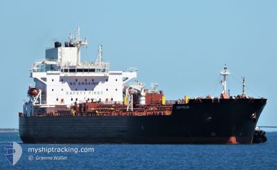
MERSEY
Tanker

Current Trip
BRIQI
| Time Travelled | 1 day |
|---|---|
| Remaining Time | --- |
| Distance Travelled | 433.89 nm |
| Remaining Distance | --- |
| AVG Speed | 11.7 Knopen |
| MAX Speed | 12.5 Knopen |
| AVG Wind | 13.5 knots |
| MAX Wind | 21 knots |
| MIN Temp | 25.1°C / 77.18°F |
| MAX Temp | 29.3°C / 84.74°F |
| Diepgang | 9.7 M |
| Positie ontvangen | 22 h, 22 m geleden |
Current Position
| Lengtegraad | --- |
|---|---|
| Breedtegraat | --- |
| Status | Under way using engine |
| Snelheid | 10 Knopen |
| Koers | 71.5° |
| Gebied | South Atlantic Ocean |
| Station | T-AIS |
| Positie ontvangen | 22 h, 22 m geleden |
Information
The current position of MERSEY is in South Atlantic Ocean with coordinates -23.96738° / -43.73098° as reported on 2025-03-02 05:31 by AIS to our vessel tracker app. The vessel's current speed is 10 Knopen
The vessel MERSEY (IMO: 9865752, MMSI: 538008664) is a Tanker It's sailing under the flag of [MH] Marshall Is.
In this page you can find informations about the vessels current position, last detected port calls, and current voyage information. If the vessels is not in coverage by AIS you will find the latest position.
The current position of MERSEY is detected by our AIS receivers and we are not responsible for the reliability of the data. The last position was recorded while the vessel was in Coverage by the Ais receivers of our vessel tracking app.
The current draught of MERSEY as reported by AIS is 9.7 meters
Weather
| Temperature | 27.1°C / 80.78°F |
|---|---|
| Wind Speed | 14 knots |
| Direction | 80° E |
| Pressure | 1018.6 hPa |
| Humidity | 75.6 % |
| Cloud Coverage | --- |


Featured Company
Last Port Calls
| Port | Arrival | Departure | Time In Port |
|---|---|---|---|
| 2025-03-01 13:10 | 2025-03-01 14:01 | 51 m | |
| 2025-02-27 19:33 | 2025-02-27 20:22 | 49 m | |
| 2025-02-19 08:44 | 2025-02-20 21:29 | 1 d | |
| 2025-02-16 15:23 | 2025-02-16 15:54 | 31 m | |
| 2025-01-30 07:45 | 2025-01-31 22:08 | 1 d | |
| 2025-01-15 01:08 | 2025-01-16 17:45 | 1 d | |
| 2025-01-04 01:17 | 2025-01-05 19:44 | 1 d |
Most Visited Ports (Last year)
| Port | Arrivals | |
|---|---|---|
| 9 | ||
| 7 | ||
| 4 | ||
| 4 | ||
| 3 | ||
| 2 |
Last Trips
| Origin | Departure | Destination | Arrival | Distance | |
|---|---|---|---|---|---|
| 2025-02-27 17:22 | 2025-03-01 10:10 | 4.40 nm | |||
| 2025-02-20 18:29 | 2025-02-27 16:33 | 182.90 nm | |||
| 2025-02-16 12:54 | 2025-02-19 05:44 | 185.08 nm | |||
| 2025-01-31 19:08 | 2025-02-16 12:23 | 353.43 nm | |||
| 2025-01-16 14:45 | 2025-01-30 04:45 | 237.95 nm | |||
| 2025-01-05 16:44 | 2025-01-14 22:08 | 2234.54 nm | |||
| 2024-12-29 01:05 | 2025-01-03 22:17 | 36.79 nm |
Events
| Tijd | Evenement | Details | Positie / Bestemming | Info |
|---|---|---|---|---|
| 2025-03-02 05:38 | Status Changed | Default Under way using engine |
-23.96145 / -43.71186
BRIQI
|
Snelheid: 10 kn Koers: 71.5° |
| 2025-03-02 05:31 | Buitenbereik |
-23.96738 / -43.73098
South Atlantic Ocean
BRIQI
|
Snelheid: 10 kn Koers: 71.5° |
|
| 2025-03-02 05:31 | Status Changed | Under way using engine Default |
-23.96784 / -43.73248
BRIQI
|
Snelheid: 10.1 kn Koers: 72° |
| 2025-03-02 05:18 | Status Changed | Default Under way using engine |
-23.97929 / -43.77047
BRIQI
|
Snelheid: 10.1 kn Koers: 72.2° |
| 2025-03-02 05:07 | Status Changed | Under way using engine Default |
-23.98904 / -43.80213
BRIQI
|
Snelheid: 9.9 kn Koers: 71° |
| 2025-03-02 04:57 | Status Changed | Default Under way using engine |
-23.99704 / -43.82889
BRIQI
|
Snelheid: 10.3 kn Koers: 73.8° |
| 2025-03-02 04:40 | Status Changed | Under way using engine Default |
-24.01119 / -43.87765
BRIQI
|
Snelheid: 9.9 kn Koers: 72° |
| 2025-03-02 04:40 | Binnenbereik |
-24.01032 / -43.87468
South Atlantic Ocean
BRIQI
|
Snelheid: 10.1 kn Koers: 72.7° |
|
| 2025-03-02 03:35 | Status Changed | Default Under way using engine |
-24.06730 / -44.06873
BRIQI
|
Snelheid: 10.2 kn Koers: 71.9° |
| 2025-03-02 03:31 | Buitenbereik |
-24.07054 / -44.07996
South Atlantic Ocean
BRIQI
|
Snelheid: 10.2 kn Koers: 71.9° |