
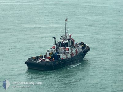
MARINA AMBER
Tug
Current Trip
| Trip Time | 1 h, 22 mins |
|---|---|
| Trip Distance | 9.14 nm |
| AVG Speed | 6.8 Knopen |
| MAX Speed | 8.2 Knopen |
| Diepgang | 4.2 M |
| AVG Wind | 11 knots |
| MAX Wind | 11.3 knots |
| MIN Temp | 25.3°C / 77.54°F |
| MAX Temp | 25.4°C / 77.72°F |
| Positie ontvangen | 34 m geleden |
Current Position
| Lengtegraad | --- |
|---|---|
| Breedtegraat | --- |
| Status | Under way using engine |
| Snelheid | 0.1 Knopen |
| Koers | --- |
| Gebied | Singapore Strait |
| Station | T-AIS |
| Positie ontvangen | 34 m geleden |
Info
Information
The current position of MARINA AMBER is in Singapore Strait with coordinates 1.30654° / 103.72788° as reported on 2025-02-18 20:46 by AIS to our vessel tracker app. The vessel's current speed is 0.1 Knopen and is currently inside the port of SINGAPORE.
The vessel MARINA AMBER (IMO: 9635432, MMSI: 564221000) is a Tug that was built in 2014 ( 11 Jaar oud ). It's sailing under the flag of [SG] Singapore.
In this page you can find informations about the vessels current position, last detected port calls, and current voyage information. If the vessels is not in coverage by AIS you will find the latest position.
The current position of MARINA AMBER is detected by our AIS receivers and we are not responsible for the reliability of the data. The last position was recorded while the vessel was in Coverage by the Ais receivers of our vessel tracking app.
The current draught of MARINA AMBER as reported by AIS is 4.2 meters
Weather
| Temperature | 25.4°C / 77.72°F |
|---|---|
| Wind Speed | 11 knots |
| Direction | 9° N |
| Pressure | 1010.2 hPa |
| Humidity | 87 % |
| Cloud Coverage | 100 % |
Featured Company
Last Port Calls
| Port | Arrival | Departure | Time In Port |
|---|---|---|---|
| 2025-02-19 03:11 | |||
| 2025-02-19 00:45 | 2025-02-19 01:49 | 1 h | |
| 2025-02-18 22:25 | 2025-02-19 00:01 | 1 h | |
| 2025-02-18 20:24 | 2025-02-18 21:53 | 1 h | |
| 2025-02-18 17:49 | 2025-02-18 19:33 | 1 h | |
| 2025-02-18 15:53 | 2025-02-18 17:29 | 1 h | |
| 2025-02-18 12:27 | 2025-02-18 15:01 | 2 h | |
| 2025-02-18 00:41 | 2025-02-18 07:21 | 6 h | |
| 2025-02-17 23:45 | 2025-02-18 00:13 | 28 m | |
| 2025-02-17 16:49 | 2025-02-17 23:01 | 6 h |
Most Visited Ports (Last year)
| Port | Arrivals | |
|---|---|---|
| 774 | ||
| 594 | ||
| 139 |
Last Trips
| Origin | Departure | Destination | Arrival | Distance | |
|---|---|---|---|---|---|
| 2025-02-19 01:49 | 2025-02-19 03:11 | 9.14 nm | |||
| 2025-02-19 00:01 | 2025-02-19 00:45 | 1.49 nm | |||
| 2025-02-18 21:53 | 2025-02-18 22:25 | 2.56 nm | |||
| 2025-02-18 19:33 | 2025-02-18 20:24 | 2.55 nm | |||
| 2025-02-18 17:29 | 2025-02-18 17:49 | 1.91 nm | |||
| 2025-02-18 15:01 | 2025-02-18 15:53 | 1.55 nm | |||
| 2025-02-18 07:21 | 2025-02-18 12:27 | 1.82 nm | |||
| 2025-02-18 00:13 | 2025-02-18 00:41 | 1.92 nm | |||
| 2025-02-17 23:01 | 2025-02-17 23:45 | 3.69 nm | |||
| 2025-02-17 16:21 | 2025-02-17 16:49 | 2.73 nm |
Events
| Tijd | Evenement | Details | Positie / Bestemming | Info |
|---|---|---|---|---|
| 2025-02-18 20:33 | Binnenbereik |
1.30655 / 103.72793
Singapore Strait
[SG] SINGAPORE
|
Snelheid: Koers: 318.4° |
|
| 2025-02-18 19:12 | Buitenbereik |
1.30652 / 103.72795
Singapore Strait
[SG] SINGAPORE
|
Snelheid: 0.1 kn Koers: 133.9° |
|
| 2025-02-18 19:11 | Stop beweging |
1.30655 / 103.72791
[SG] SINGAPORE
|
Snelheid: 0.2 kn Koers: 511° |
|
| 2025-02-18 19:11 | Aankomsthaven |
|
1.30655 / 103.72791
[SG] SINGAPORE
|
Snelheid: 1.9 kn Koers: 511° |
| 2025-02-18 18:28 | Status Changed | Under way using engine Default |
1.24746 / 103.71069
BATAM BV
|
Snelheid: 6.7 kn Koers: 52° |
| 2025-02-18 18:25 | Status Changed | Default Under way using engine |
1.24515 / 103.70738
BATAM BV
|
Snelheid: 6.6 kn Koers: 59.3° |
| 2025-02-18 18:17 | Status Changed | Under way using engine Default |
1.23709 / 103.69503
BATAM BV
|
Snelheid: 6.6 kn Koers: 55° |
| 2025-02-18 18:09 | Status Changed | Default Under way using engine |
1.22747 / 103.68303
BATAM BV
|
Snelheid: 7.4 kn Koers: 60.7° |
| 2025-02-18 18:01 | Status Changed | Under way using engine Default |
1.22198 / 103.67039
BATAM BV
|
Snelheid: 7.6 kn Koers: 142° |
| 2025-02-18 18:01 | Binnenbereik |
1.22053 / 103.67285
Singapore Strait
|
Snelheid: 7.7 kn Koers: 98.6° |