
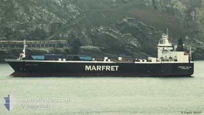
MARFRET NIOLON
Ro-Ro Cargo
Current Trip
| Time Travelled | 3 days |
|---|---|
| Remaining Time | --- |
| Distance Travelled | 847.24 nm |
| Remaining Distance | --- |
| AVG Speed | 12.6 Knopen |
| MAX Speed | 15.8 Knopen |
| AVG Wind | 14.7 knots |
| MAX Wind | 25 knots |
| MIN Temp | -0.3°C / 31.46°F |
| MAX Temp | 11.9°C / 53.42°F |
| Diepgang | 5.5 M |
| Positie ontvangen | 1 d geleden |
Current Position
| Lengtegraad | --- |
|---|---|
| Breedtegraat | --- |
| Status | Under way using engine |
| Snelheid | 9.7 Knopen |
| Koers | 219.5° |
| Gebied | Celtic Sea |
| Station | T-AIS |
| Positie ontvangen | 1 d geleden |
Info
Information
The current position of MARFRET NIOLON is in Celtic Sea with coordinates 48.77457° / -6.18889° as reported on 2025-03-16 16:30 by AIS to our vessel tracker app. The vessel's current speed is 9.7 Knopen and is heading at the port of DEGRAD DES CANNES. The estimated time of arrival as calculated by MyShipTracking vessel tracking app is 2025-03-30 12:00 LT
The vessel MARFRET NIOLON (IMO: 8912388, MMSI: 253343000) is a Ro-Ro Cargo that was built in 1991 ( 34 Jaar oud ). It's sailing under the flag of [LU] Luxembourg.
In this page you can find informations about the vessels current position, last detected port calls, and current voyage information. If the vessels is not in coverage by AIS you will find the latest position.
The current position of MARFRET NIOLON is detected by our AIS receivers and we are not responsible for the reliability of the data. The last position was recorded while the vessel was in Coverage by the Ais receivers of our vessel tracking app.
The current draught of MARFRET NIOLON as reported by AIS is 5.5 meters
Weather
| Temperature | 12°C / 53.6°F |
|---|---|
| Wind Speed | 13 knots |
| Direction | 152° SSE |
| Pressure | 1006 hPa |
| Humidity | 62.7 % |
| Cloud Coverage | 100 % |
Featured Company
Last Port Calls
| Port | Arrival | Departure | Time In Port |
|---|---|---|---|
| 2025-03-13 20:31 | 2025-03-15 04:07 | 1 d | |
| 2025-03-10 20:28 | 2025-03-12 21:15 | 2 d | |
| 2025-02-24 05:07 | 2025-02-24 21:20 | 16 h | |
| 2025-02-17 07:30 | 2025-02-18 05:56 | 22 h | |
| 2025-01-29 08:24 | 2025-02-01 07:37 | 2 d | |
| 2025-01-24 12:45 | 2025-01-27 20:56 | 3 d | |
| 2025-01-07 05:38 | 2025-01-10 11:48 | 3 d | |
| 2025-01-06 04:58 | 2025-01-06 18:56 | 13 h | |
| 2025-01-03 05:08 |
Most Visited Ports (Last year)
| Port | Arrivals | |
|---|---|---|
| 9 | ||
| 8 | ||
| 8 | ||
| 7 | ||
| 2 | ||
| 1 |
Last Trips
| Origin | Departure | Destination | Arrival | Distance | |
|---|---|---|---|---|---|
| 2025-03-12 21:15 | 2025-03-13 20:31 | 243.78 nm | |||
| 2025-02-24 21:20 | 2025-03-10 20:28 | 3681.46 nm | |||
| 2025-02-18 05:56 | 2025-02-24 05:07 | 1256.72 nm | |||
| 2025-02-01 07:37 | 2025-02-17 07:30 | 4057.54 nm | |||
| 2025-01-27 20:56 | 2025-01-29 08:24 | 247.02 nm | |||
| 2025-01-10 11:48 | 2025-01-24 12:45 | 3921.77 nm | |||
| 2025-01-06 18:56 | 2025-01-07 05:38 | 109.71 nm | |||
| 2025-01-03 05:08 | 2025-01-06 04:58 | 806.29 nm |
Events
| Tijd | Evenement | Details | Positie / Bestemming | Info |
|---|---|---|---|---|
| 2025-03-16 17:21 | Status Changed | Default Under way using engine |
48.67339 / -6.32775
GFDDC
|
Snelheid: 9.7 kn Koers: 219.5° |
| 2025-03-16 16:30 | Buitenbereik |
48.77457 / -6.18889
Celtic Sea
GFDDC
|
Snelheid: 9.7 kn Koers: 219.5° |
|
| 2025-03-16 16:30 | Status Changed | Under way using engine Default |
48.77491 / -6.18846
GFDDC
|
Snelheid: 9 kn Koers: 223° |
| 2025-03-16 15:33 | Status Changed | Default Under way using engine |
48.88827 / -6.03177
GFDDC
|
Snelheid: 9.8 kn Koers: 222.9° |
| 2025-03-16 12:54 | Status Changed | Under way using engine Default |
49.17476 / -5.45841
GFDDC
|
Snelheid: 12.7 kn Koers: 243° |
| 2025-03-16 12:32 | Status Changed | Default Under way using engine |
49.20771 / -5.35398
GFDDC
|
Snelheid: 12.4 kn Koers: 243.1° |
| 2025-03-16 12:28 | Gevonden in zee | French part of the Celtic Sea |
49.21409 / -5.33475
Celtic Sea
GFDDC
|
Snelheid: 12.4 kn Koers: 243.1° |
| 2025-03-16 12:28 | Status Changed | Under way using engine Default |
49.21431 / -5.33415
GFDDC
|
Snelheid: 12 kn Koers: 243° |
| 2025-03-16 12:19 | Status Changed | Default Under way using engine |
49.22805 / -5.29324
GFDDC
|
Snelheid: 12.1 kn Koers: 243.2° |
| 2025-03-16 11:38 | Wijzig zee gebeid | United Kingdom part of the Celtic Sea United Kingdom part of the English Channel |
49.28998 / -5.10432
Celtic Sea
GFDDC
|
Snelheid: 12.2 kn Koers: 244° |